1990s Maps of Southampton County, Virginia
Explore 4 historic maps of Southampton County from the 1990s. These maps offer a rare glimpse into what life looked like during the 1990s — showing old roads, neighborhoods, homes, and landmarks that have changed or disappeared over time.
Whether you're researching your family's past, planning a metal detecting trip, or studying how Southampton County's landscape evolved across the 1990s, these high-resolution maps are a powerful tool for exploring the history of this region.
- Focus on a specific era: All maps on this page are from the 1990s, giving you a focused view of this time period.
- See what’s changed: Compare century-old streets, trails, and buildings to today's modern landscape using overlays and satellite layers.
- Research with precision: Use these maps for genealogy, historical research, land use analysis, or educational projects.
- View, download, or print: Maps are fully viewable online in high resolution, and can be downloaded or printed for your own records.
Start exploring Southampton County's history through authentic maps from the 1990s. This is your window into the past.
Southampton County, VA maps
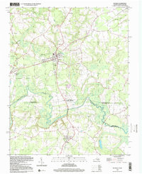
(4)- 1990 Map of Emporia
 1990 Emporia1990 Print · USGSThe Southside Virginia borderlands are captured here in the late twentieth century, showing the critical rail and river networks of the region. Genealogists and local historians can trace family roots through rural communities like Alberta, Boykins, and Dolphin along the Meherrin River.
 - 1997 Map of Boykins, 2000 Print
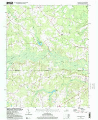
 1997 Boykins2000 Print · USGSThe Virginia and North Carolina borderlands come into focus in the late nineties as a landscape of river bends and rail towns. Trace local roots at Beechwood Cem or locate rural landmarks like Galilee Ch and Meherrin Sch.
 - 1997 Map of Claresville, 2000 Print
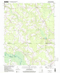
 1997 Claresville2000 Print · USGSAcross the Virginia and North Carolina borderlands in the late twentieth century, this map shows a rural landscape shaped by slow-moving creeks and millponds. Genealogists can locate family landmarks like Bryants Corner, Turners Crossroads, and several country churches including Mt Zion Ch.
 - 1997 Map of Sunbeam, 2000 Print
 1997 Sunbeam2000 Print · USGSThe Virginia and North Carolina state line runs through this late-century rural landscape, where small crossroads communities and millponds define the border country. Researchers can trace family sites at Hollywood Cem or follow old routes through Sunbeam and Statesville.
End of results
Showing maps 1-4 of 4
Top cities of Southampton County
- Courtland historical maps
- Boykins historical maps
- Sedley historical maps
- Ivor historical maps
- Newsoms historical maps
- Capron historical maps
See more
Frequently asked questions
- What are the different types of historical maps available for Southampton County?
- What is the oldest map of Southampton County?
- Where can I purchase historical maps of Southampton County for my home or office?
- Where can I download high-res historical maps of Southampton County?
- Are there historical topographic maps available for Southampton County?
- Is there historical aerial imagery available for Southampton County?
- Where are historical maps of Southampton County sourced from?