1940s Maps of Stafford County, Virginia
Explore 20 historic maps of Stafford County from the 1940s. These maps offer a rare glimpse into what life looked like during the 1940s — showing old roads, neighborhoods, homes, and landmarks that have changed or disappeared over time.
Whether you're researching your family's past, planning a metal detecting trip, or studying how Stafford County's landscape evolved across the 1940s, these high-resolution maps are a powerful tool for exploring the history of this region.
- Focus on a specific era: All maps on this page are from the 1940s, giving you a focused view of this time period.
- See what’s changed: Compare century-old streets, trails, and buildings to today's modern landscape using overlays and satellite layers.
- Research with precision: Use these maps for genealogy, historical research, land use analysis, or educational projects.
- View, download, or print: Maps are fully viewable online in high resolution, and can be downloaded or printed for your own records.
Start exploring Stafford County's history through authentic maps from the 1940s. This is your window into the past.
Stafford County, VA maps
(20)- 1940 Map of Quantico
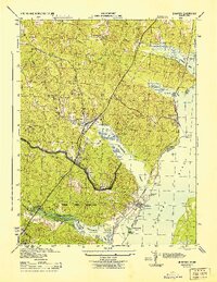
 1940 Quantico1940 Print · USGSCoastal Virginia and Maryland are captured here during the late pre-war era, showing the growing military footprint around the Potomac. Genealogists can trace family names and landmarks like Sinclairs Mill, Bacon Race School, and the historic Dumfries settlement.2 unique versions available
 - 1942 Map of Guinea
 1942 Guinea1942 Print · USGSSpotsylvania and Caroline counties are seen here in the early 1940s as the rail-driven economy of the Rappahannock valley meets the expansion of federal military lands. Genealogists can locate family-named hubs like Flippos Corner, rural schools such as New Hope School, and the crossroads at Guinea.
 - 1942 Map of Rappahannock Academy, 1944 Print
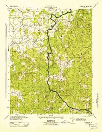
 1942 Rappahannock Academy1944 Print · USGSThe Rappahannock River valley in the early 1940s reveals a rural landscape undergoing a massive military transformation. You can trace the early layout of the A P Hill Military Reservation and locate historic community centers like Rappahannock Academy and Travis Mill.
 - 1943 Map of Quantico
 1943 Quantico1943 Print · USGSCoastal Northern Virginia in the mid-1940s reveals a region transitioning from a rural riverfront to a strategic military hub. Researchers can trace the early layout of the Marine Corps Reservation or locate family sites like Shacklet PO and Old Chopawamsic Ch.
 - 1943 Map of Catlett, 1955 Print
 1943 Catlett1955 Print · USGSMid-century Fauquier and Prince William counties center on the Southern Railway as it links rural hubs and farming estates. Genealogists can trace family footprints across dozens of local landmarks, from Vint Hill Farm to Dunkard Church and Balls Mill.2 unique versions available
 - 1943 Map of Salem Church, 1961 Print
 1943 Salem Church1961 Print · USGSCentral Virginia during the mid-forties reveals a rural landscape of family-named runs and hilltop parishes. Genealogists and historians can trace local life through markers like Chancellor Sch, Zoan Ch, and the crossroads at Holly Corner.
 - 1943 Map of Fredericksburg, 1961 Print
 1943 Fredericksburg1961 Print · USGSVirginia's Rappahannock valley is captured here during the war years, balancing its deep Civil War history with mid-century development. Genealogists and historians can trace family-named sites and landmarks like Oak Hill Cem, Dunker Ch, and the Meade Pyramid.
 - 1944 Map of Salem Church
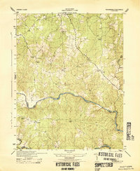
 1944 Salem Church1944 Print · USGSSpotsylvania and Stafford Counties were still primarily rural landscapes of crossroads and small farms during the mid-1940s. Genealogists can trace family roots through specific landmarks like Spring Knoll Farm or local institutions such as Diggs School and Zoan Church.
 - 1944 Map of Widewater
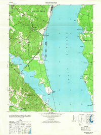
 1944 Widewater1944 Print · USGSThe Potomac shoreline at the height of the Second World War shows a landscape defined by military transit and riverfront commerce. Genealogists and local historians can trace the Richmond Fredericksburg and Potomac rail stops and small hubs like Mountjoy Store and Clifton Beach.
 - 1944 Map of Somerville
 1944 Somerville1944 Print · USGSThe rural borders of Fauquier and Stafford Counties are captured here during the mid-forties. Researchers can locate family landmarks and early post offices at Somerville PO, Tacketts Mill, and Hearts Delight Ch Delight.
 - 1944 Map of Quantico
 1944 Quantico1944 Print · USGSCoastal Prince William County is captured here at the height of the second World War, showing the expansion of military and transit infrastructure. Genealogists and historians can trace old landmarks like Little Union Ch, the Midway Island Housing Project, and the busy Quantico waterfront.2 unique versions available
 - 1944 Map of Passapatanzy
 1944 Passapatanzy1944 Print · USGSThe Virginia riverfront along the Potomac and Rappahannock appears here during the height of the Second World War. Genealogists and historians can trace family-named landmarks and rural hubs like Passapatanzy, Sealston PO, and the U. S. Government Railroad.
 - 1944 Map of Richardsville
 1944 Richardsville1944 Print · USGSRichardsville and the surrounding Virginia Piedmont are captured here in the 1940s as the river-riven borders of four counties meet. Researchers can trace the legacy of rural life through landmarks like Oakland Church, the Goldvein School, and Harding Mill.
 - 1944 Map of Stafford
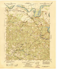
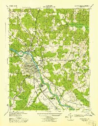
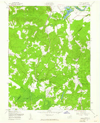
 1944 Stafford1944 Print · USGSStafford and its surrounding crossroads communities appear here during the mid-forties, showing a landscape of small farms, churches, and early highway corridors. Genealogists can trace family landmarks like Sheltons Shop, Stafford Training Sch, and Aquia Ch.
 - 1944 Map of Fredericksburg
 1944 Fredericksburg1944 Print · USGSFredericksburg and the Rappahannock River valley are captured in detail during the mid-1940s, showing the intersection of Civil War heritage and pre-suburban growth. Trace local history at the Fredericksburg Battle Field 1862, Howison PO, and Hulls Ch.
 - 1944 Map of Storck
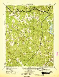
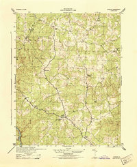 1944 Storck1944 Print · USGSStafford County communities and crossroads appear in detail during the mid-1940s, showing the rural structure of the Virginia Piedmont. Researchers can trace local family landmarks and community centers like Mt Olive School, Dodds Store, and Hartwood Church.
 - 1946 Map of Stafford
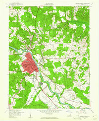
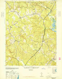 1946 Stafford1946 Print · USGSStafford County at the end of the Second World War shows a rural landscape increasingly shaped by its proximity to major transportation corridors and military grounds. Researchers can trace the local rail-and-road economy through Brooke on the Richmond Fredericksburg and Potomac and historic sites like Aquia Ch.
 - 1946 Map of Widewater, 1953 Print
 1946 Widewater1953 Print · USGSStafford County at the end of the war shows a river-dependent landscape where the railroad still dictated the pace of growth. Genealogists can trace family landmarks like Mountjoy Store, Fritters Corner, and the Oak Grove Ch school and church.
 - 1948 Map of Washington
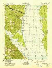
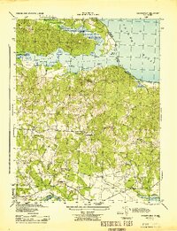
 1948 Washington1948 Print · USGSThe Potomac and Chesapeake regions in the late 1940s reveal a landscape of expanding military reach and deep-rooted Tidewater settlements. Trace old rail corridors like the Richmond Fredericksburg & Potomac RR or locate landmarks like the Wakefield Washington Monument and St. Marys College.2 unique versions available
 - 1949 Map of Guinea, 1961 Print
 1949 Guinea1961 Print · USGSSpotsylvania and Caroline Counties appear here just after the war, showing a landscape of family-named crossroads and established rail corridors. Genealogists can trace rural communities like Flippos Corner and Villboro, or locate the historic Stonewall Jackson Shrine.
End of results
Showing maps 1-20 of 20
Top cities of Stafford County
- Stafford historical maps
- Falmouth historical maps
- Southern Gateway historical maps
- Boswell's Corner historical maps
- Camp Barrett historical maps
Frequently asked questions
- What are the different types of historical maps available for Stafford County?
- What is the oldest map of Stafford County?
- Where can I purchase historical maps of Stafford County for my home or office?
- Where can I download high-res historical maps of Stafford County?
- Are there historical topographic maps available for Stafford County?
- Is there historical aerial imagery available for Stafford County?
- Where are historical maps of Stafford County sourced from?