1990s Maps of Stafford County, Virginia
Explore 8 historic maps of Stafford County from the 1990s. These maps offer a rare glimpse into what life looked like during the 1990s — showing old roads, neighborhoods, homes, and landmarks that have changed or disappeared over time.
Whether you're researching your family's past, planning a metal detecting trip, or studying how Stafford County's landscape evolved across the 1990s, these high-resolution maps are a powerful tool for exploring the history of this region.
- Focus on a specific era: All maps on this page are from the 1990s, giving you a focused view of this time period.
- See what’s changed: Compare century-old streets, trails, and buildings to today's modern landscape using overlays and satellite layers.
- Research with precision: Use these maps for genealogy, historical research, land use analysis, or educational projects.
- View, download, or print: Maps are fully viewable online in high resolution, and can be downloaded or printed for your own records.
Start exploring Stafford County's history through authentic maps from the 1990s. This is your window into the past.
Stafford County, VA maps
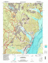
(8)- 1994 Map of Stafford, 1997 Print
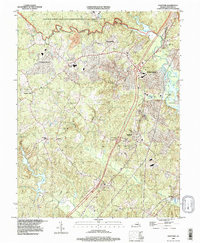 1994 Stafford1997 Print · USGSNorthern Virginia's suburban transition is visible in the mid-nineties as traditional crossroads like Stafford and Brooke met modern expansion. Trace historical river landings and local landmarks such as Government Island, Coal Landing, and Aquia Cem.
 - 1994 Map of Fredericksburg, 1997 Print
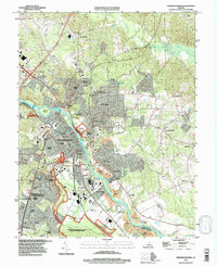 1994 Fredericksburg1997 Print · USGSFredericksburg and the Rappahannock River valley appear here in the mid-1990s, balanced between historic preservation and suburban growth. Local researchers can trace family sites near Ferry Farm, the National Cemetery, and old junctions like Stones Corner.
 - 1994 Map of Rappahannock Academy, 1997 Print
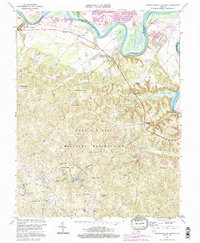 1994 Rappahannock Academy1997 Print · USGSCaroline County in the mid-1990s reveals a landscape where military reservation boundaries meet historic riverfront life. Trace local family roots through numerous named crossroads like Samuels Corner and old landmarks such as Rappahannock Academy.3 unique versions available
 - 1994 Map of Salem Church, 1997 Print
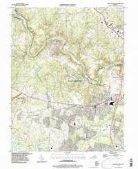 1994 Salem Church1997 Print · USGSSpotsylvania County in the mid-1990s reveals a unique intersection of Civil War preservation and modern suburban growth. Genealogists and historians can trace old road networks like Plank Road through crossroads at Chancellor and Fivemile Fork.
 - 1994 Map of Quantico, 1998 Print
 1994 Quantico1998 Print · USGSCoastal Prince William County in the mid-1990s shows a landscape of military installations and expansive nature preserves. Researchers can trace the boundaries of Marine Corps Base (Quantico) and locate historical landmarks like Dumfries and Possum Point.
 - 1997 Map of Joplin, 2000 Print
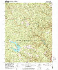 1997 Joplin2000 Print · USGSStafford and Prince William counties are shown here in the late nineties, featuring the expansive military grounds and protected forests south of D.C. Researchers can locate small settlements like Joplin or Kopp, and trace training sites such as Combat Village.
 - 1998 Map of Widewater, 2001 Print
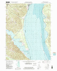 1998 Widewater2001 Print · USGSThe Potomac shoreline at the turn of the millennium reveals a blend of military grounds and quiet river landings. Genealogists and historians can trace old community hubs like Mountjoy Store, Arkendale, and the notably named Youbedamn Landing.
 - 1998 Map of Richardsville, 2001 Print
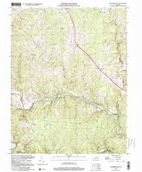 1998 Richardsville2001 Print · USGSThe confluence region of Fauquier and Culpeper counties is captured here in the late twentieth century, centered on the river-fed landscape near Richardsville. Researchers can trace the rural layout of communities like Goldvein and Sumerduck or locate family sites near Union Ch.
End of results
Showing maps 1-8 of 8
Top cities of Stafford County
- Stafford historical maps
- Falmouth historical maps
- Southern Gateway historical maps
- Boswell's Corner historical maps
- Camp Barrett historical maps
Frequently asked questions
- What are the different types of historical maps available for Stafford County?
- What is the oldest map of Stafford County?
- Where can I purchase historical maps of Stafford County for my home or office?
- Where can I download high-res historical maps of Stafford County?
- Are there historical topographic maps available for Stafford County?
- Is there historical aerial imagery available for Stafford County?
- Where are historical maps of Stafford County sourced from?