1960s Maps of Bluefield, Virginia
Explore 5 historic maps of Bluefield from the 1960s. These maps offer a rare glimpse into what life looked like during the 1960s — showing old roads, neighborhoods, homes, and landmarks that have changed or disappeared over time.
Whether you're researching your family's past, planning a metal detecting trip, or studying how Bluefield's landscape evolved across the 1960s, these high-resolution maps are a powerful tool for exploring the history of this region.
- Focus on a specific era: All maps on this page are from the 1960s, giving you a focused view of this time period.
- See what’s changed: Compare century-old streets, trails, and buildings to today's modern landscape using overlays and satellite layers.
- Research with precision: Use these maps for genealogy, historical research, land use analysis, or educational projects.
- View, download, or print: Maps are fully viewable online in high resolution, and can be downloaded or printed for your own records.
Start exploring Bluefield's history through authentic maps from the 1960s. This is your window into the past.
Bluefield, VA maps
(5)- 1961 Map of Bluefield
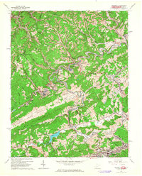
 1961 Bluefield1961 Print · USGSThe coalfields and mountain ridges of southern West Virginia and southwest Virginia are captured in the early sixties. Genealogists can trace family ties through rail-linked towns like Princeton and Richlands or along the shores of Bluestone Reservoir.
 - 1962 Map of Bramwell, 1964 Print
 1962 Bramwell1964 Print · USGSThe coal and rail corridor of the West Virginia-Virginia border is frozen in time during the early sixties. Genealogists and historians can trace family plots at Pocahontas Cem and Mt Tabor Cem or locate industrial sites like the strip mines near Bramwell.2 unique versions available
 - 1962 Map of Bluefield, 1964 Print
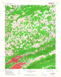 1962 Bluefield1964 Print · USGSThe rail-and-ridge country of the West Virginia-Virginia border shows its mid-century growth and industrial character in the early sixties. Genealogists can locate family names at Roselawn Memorial Gardens Cem or trace landmarks like Bluefield State Teachers College and Mountaineer Speedway.3 unique versions available
 - 1968 Map of Bastian, 1971 Print
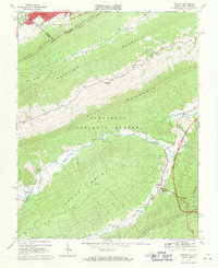 1968 Bastian1971 Print · USGSBland and Tazewell Counties are captured in the late sixties, where the urban edge of Bluefield meets the dense ridges of the Jefferson National Forest. Genealogists and historians can trace rural life at Bastian, Hicksville, and Grapefield, or locate family landmarks like Green Valley Ch and Clear Fork Ch.2 unique versions available
 - 1968 Map of Cove Creek, 1971 Print
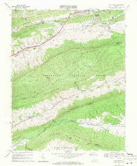 1968 Cove Creek1971 Print · USGSThe Virginia mountain country near the Bland and Tazewell border is documented here in the late sixties. Genealogists and local historians can locate Maple Hill Cemetery, the Shawver Mill, and schools like Dudley Sch along the river valleys.2 unique versions available
End of results
Showing maps 1-5 of 5
Top cities near Bluefield
- Bluefield historical maps
- Princeton historical maps
- Tazewell historical maps
- Brush Fork historical maps
- Springville historical maps
- Gratton historical maps
See more
Top neighborhoods of Bluefield
Frequently asked questions
- What are the different types of historical maps available for Bluefield?
- What is the oldest map of Bluefield?
- Where can I purchase historical maps of Bluefield for my home or office?
- Where can I download high-res historical maps of Bluefield?
- Are there historical topographic maps available for Bluefield?
- Is there historical aerial imagery available for Bluefield?
- Where are historical maps of Bluefield sourced from?