1910s Maps of Cedar Bluff, Virginia
Explore 4 historic maps of Cedar Bluff from the 1910s. These maps offer a rare glimpse into what life looked like during the 1910s — showing old roads, neighborhoods, homes, and landmarks that have changed or disappeared over time.
Whether you're researching your family's past, planning a metal detecting trip, or studying how Cedar Bluff's landscape evolved across the 1910s, these high-resolution maps are a powerful tool for exploring the history of this region.
- Focus on a specific era: All maps on this page are from the 1910s, giving you a focused view of this time period.
- See what’s changed: Compare century-old streets, trails, and buildings to today's modern landscape using overlays and satellite layers.
- Research with precision: Use these maps for genealogy, historical research, land use analysis, or educational projects.
- View, download, or print: Maps are fully viewable online in high resolution, and can be downloaded or printed for your own records.
Start exploring Cedar Bluff's history through authentic maps from the 1910s. This is your window into the past.
Cedar Bluff, VA maps
(4)- 1912 Map of Pounding Mill
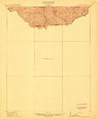 1912 Pounding Mill1912 Print · USGSThe McDowell and Tazewell borderlands appear here in the decade before the First World War, showing the early infrastructure of this mountainous region. Researchers can trace the path of Squire Jim Road and locate the settlement of Horsepen among the headwaters of Big Creek.
 - 1915 Map of Richlands
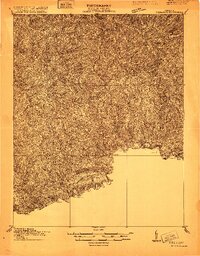 1915 Richlands1915 Print · USGSThe Clinch River valley in the years before the Great War is a network of coal-country settlements and mountain passes. Genealogists can locate family schoolhouses like Drill School or trace the early Norfolk and Western rail lines through Raven and Richlands.
 - 1916 Map of Pounding Mill
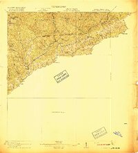 1916 Pounding Mill1916 Print · USGSThe Virginia and West Virginia state line was a rugged landscape of isolated mountain hollows and ridge-top knobs during the early twentieth century. Genealogists can trace family footprints near Greasy Creek School, the NORFOLK AND WESTERN RR, and the settlement of Sayersville.
 - 1916 Map of Richlands
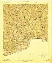 1916 Richlands1916 Print · USGSThe Clinch River valley was entering a period of industrial growth just before the First World War as rail lines followed the water. Genealogists can trace family roots through numerous mountain schools and hamlets like Antioch School, Red Ash, and Cedar Bluff.5 unique versions available
End of results
Showing maps 1-4 of 4
Top cities near Cedar Bluff
- Richlands historical maps
- Tazewell historical maps
- Raven historical maps
- Saltville historical maps
- Claypool Hill historical maps
- Honaker historical maps
See more
Top neighborhoods of Cedar Bluff
Frequently asked questions
- What are the different types of historical maps available for Cedar Bluff?
- What is the oldest map of Cedar Bluff?
- Where can I purchase historical maps of Cedar Bluff for my home or office?
- Where can I download high-res historical maps of Cedar Bluff?
- Are there historical topographic maps available for Cedar Bluff?
- Is there historical aerial imagery available for Cedar Bluff?
- Where are historical maps of Cedar Bluff sourced from?