1930s Maps of Cedar Bluff, Virginia
Explore 2 historic maps of Cedar Bluff from the 1930s. These maps offer a rare glimpse into what life looked like during the 1930s — showing old roads, neighborhoods, homes, and landmarks that have changed or disappeared over time.
Whether you're researching your family's past, planning a metal detecting trip, or studying how Cedar Bluff's landscape evolved across the 1930s, these high-resolution maps are a powerful tool for exploring the history of this region.
- Focus on a specific era: All maps on this page are from the 1930s, giving you a focused view of this time period.
- See what’s changed: Compare century-old streets, trails, and buildings to today's modern landscape using overlays and satellite layers.
- Research with precision: Use these maps for genealogy, historical research, land use analysis, or educational projects.
- View, download, or print: Maps are fully viewable online in high resolution, and can be downloaded or printed for your own records.
Start exploring Cedar Bluff's history through authentic maps from the 1930s. This is your window into the past.
Cedar Bluff, VA maps
(2)- 1934 Map of Liberty
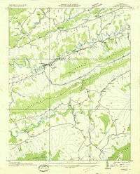 1934 Liberty1934 Print · USGSTazewell County's Appalachian ridges were well-established by the mid-1930s, defined by coal-hauling rail lines and a network of mountain gap communities. Genealogists can trace family landmarks like Phillips Cem, Bandys Chapel, and rural schools like Raven Nest Sch and Cove Sch.
 - 1935 Map of Richlands
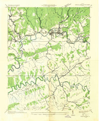 1935 Richlands1935 Print · USGSSouthwest Virginia's industrial and mountain landscape comes alive in the mid-1930s as the Clinch River valley hums with activity. Researchers can trace the rail-side growth of Richlands and Cedar Bluff, find remote mountain schools like Red Ash Sch, and locate the Premier Coal Corporation Camp.
End of results
Showing maps 1-2 of 2
Top cities near Cedar Bluff
- Richlands historical maps
- Tazewell historical maps
- Raven historical maps
- Saltville historical maps
- Claypool Hill historical maps
- Honaker historical maps
See more
Top neighborhoods of Cedar Bluff
Frequently asked questions
- What are the different types of historical maps available for Cedar Bluff?
- What is the oldest map of Cedar Bluff?
- Where can I purchase historical maps of Cedar Bluff for my home or office?
- Where can I download high-res historical maps of Cedar Bluff?
- Are there historical topographic maps available for Cedar Bluff?
- Is there historical aerial imagery available for Cedar Bluff?
- Where are historical maps of Cedar Bluff sourced from?