1980s Maps of Virginia Beach, Virginia
Explore 5 historic maps of Virginia Beach from the 1980s. These maps offer a rare glimpse into what life looked like during the 1980s — showing old roads, neighborhoods, homes, and landmarks that have changed or disappeared over time.
Whether you're researching your family's past, planning a metal detecting trip, or studying how Virginia Beach's landscape evolved across the 1980s, these high-resolution maps are a powerful tool for exploring the history of this region.
- Focus on a specific era: All maps on this page are from the 1980s, giving you a focused view of this time period.
- See what’s changed: Compare century-old streets, trails, and buildings to today's modern landscape using overlays and satellite layers.
- Research with precision: Use these maps for genealogy, historical research, land use analysis, or educational projects.
- View, download, or print: Maps are fully viewable online in high resolution, and can be downloaded or printed for your own records.
Start exploring Virginia Beach's history through authentic maps from the 1980s. This is your window into the past.
Virginia Beach, VA maps
(5)- 1981 Map of Cheriton
 1981 Cheriton1981 Print · USGSThe Virginia Eastern Shore in the early eighties is mapped here at the junction of the bay and ocean. Researchers can trace the coastal heritage of the peninsula through landmarks like the Cape Charles Light and settlements such as Oyster, Townsend, and Eastville.
 - 1984 Map of Chincoteague
 1984 Chincoteague1984 Print · USGSThe Virginia Eastern Shore and Delmarva Peninsula are captured here in the mid-1980s, showcasing a landscape of barrier islands and tidewater towns. Researchers can trace the Penn Central rail line through Accomac or locate the Wallops Flight Facility (NASA) and Chincoteague Nat Wildlife Refuge.2 unique versions available
 - 1984 Map of Williamsburg, 1985 Print
 1984 Williamsburg1985 Print · USGSThe Virginia Peninsula and Chesapeake Bay shores are shown in the mid-1980s, revealing a landscape defined by colonial heritage and massive military installations. Researchers can trace the grounds of the College of William and Mary, the Yorktown National Cemetery, and the historic Jamestown Island.3 unique versions available
 - 1985 Map of Virginia Beach
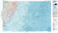
 1985 Virginia Beach1985 Print · USGSThe Virginia and North Carolina coastline in the mid-eighties shows a landscape of strategic naval bases and expansive wildlife refuges. Trace the development of Sandbridge Beach, locate inland points like Dawley Corners, and explore the marshes of Back Bay.
 - 1985 Map of Norfolk, 1986 Print
 1985 Norfolk1986 Print · USGSThe Tidewater region in the mid-eighties shows the dense urban expansion of the coastal cities alongside the preservation of the Great Dismal Swamp. Researchers can trace rural family-named crossroads and historic transit routes like the Seaboard Coast Line or find Somerton and Lake Drummond.3 unique versions available
End of results
Showing maps 1-5 of 5
Top cities of Virginia Beach
Frequently asked questions
- What are the different types of historical maps available for Virginia Beach?
- What is the oldest map of Virginia Beach?
- Where can I purchase historical maps of Virginia Beach for my home or office?
- Where can I download high-res historical maps of Virginia Beach?
- Are there historical topographic maps available for Virginia Beach?
- Is there historical aerial imagery available for Virginia Beach?
- Where are historical maps of Virginia Beach sourced from?