1990s Maps of Virginia Beach, Virginia
Explore 2 historic maps of Virginia Beach from the 1990s. These maps offer a rare glimpse into what life looked like during the 1990s — showing old roads, neighborhoods, homes, and landmarks that have changed or disappeared over time.
Whether you're researching your family's past, planning a metal detecting trip, or studying how Virginia Beach's landscape evolved across the 1990s, these high-resolution maps are a powerful tool for exploring the history of this region.
- Focus on a specific era: All maps on this page are from the 1990s, giving you a focused view of this time period.
- See what’s changed: Compare century-old streets, trails, and buildings to today's modern landscape using overlays and satellite layers.
- Research with precision: Use these maps for genealogy, historical research, land use analysis, or educational projects.
- View, download, or print: Maps are fully viewable online in high resolution, and can be downloaded or printed for your own records.
Start exploring Virginia Beach's history through authentic maps from the 1990s. This is your window into the past.
Virginia Beach, VA maps
(2)- 1990 Map of Virginia Beach
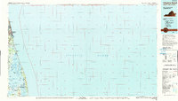 1990 Virginia Beach1990 Print · USGSThe Virginia and North Carolina coastline in the early nineties showcases a landscape of naval installations and protected wildlife corridors. Genealogists and historians can trace the development of Virginia Beach alongside older communities like Dawley Corners and Sigma.
 - 1994 Map of Kempsville, 2000 Print
 1994 Kempsville2000 Print · USGSCoastal Virginia's Tidewater region shows a complex weave of suburban expansion and historical roots in the mid-1990s. Genealogists and local historians can trace legacy sites from the Old Donation Ch Cem to the sprawling grounds of Woodlawn Mem Gardens.
End of results
Showing maps 1-2 of 2
Top cities of Virginia Beach
Frequently asked questions
- What are the different types of historical maps available for Virginia Beach?
- What is the oldest map of Virginia Beach?
- Where can I purchase historical maps of Virginia Beach for my home or office?
- Where can I download high-res historical maps of Virginia Beach?
- Are there historical topographic maps available for Virginia Beach?
- Is there historical aerial imagery available for Virginia Beach?
- Where are historical maps of Virginia Beach sourced from?