Old Maps of Virginia Beach, Virginia for Academic Research
Study the evolution of Virginia Beach with 71 high-resolution historic maps. Whether you're teaching, researching, or modeling changes in land use, these maps provide essential visual documentation of urban, environmental, and geographic change.
- Analyze long-term change: Track patterns in development, transportation, and natural features.
- Ideal for environmental or urban studies: Support academic projects with primary historical map data.
- Use in the classroom or lab: Educators and researchers rely on these maps to bring historical context to life.
These maps are a powerful tool for teaching, research, and visualizing how Virginia Beach has changed over the decades.
Virginia Beach, VA maps
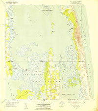
(71)- 1893 Map of Virginia Beach
 1893 Virginia Beach1893 Print · USGSThe Virginia and North Carolina coastline is shown here in the early 1890s, long before modern development transformed the Outer Banks. Researchers can trace the original chain of Life Saving Stations along the shore from Cape Henry down to False Cape.
 - 1907 Map of Norfolk
 1907 Norfolk1907 Print · USGSCoastal Virginia is mapped here at the dawn of the twentieth century, during the bustle of the great Jamestown Exposition. Researchers can trace the early rail-and-canal economy through the Albemarle and Chesapeake Canal, the Navy Yard, and historic outposts like the Cape Henry Light.
 - 1916 Map of Back Bay
 1916 Back Bay1916 Print · USGSThe Virginia-North Carolina coast and the shallow reaches of Back Bay appear here in the early twentieth century. Researchers can trace the line of coastal outposts like the False Cape Life Saving Sta. and the early layout of Knotts Island.
 - 1918 Map of Cape Henry, 1961 Print
 1918 Cape Henry1961 Print · USGSThe Virginia coast at the close of the First World War shows a landscape of tidal inlets and rail-dependent settlements before modern expansion. Researchers can locate early landmarks like Old Donation Church, London Bridge, and the Dam Neck Mills.
 - 1919 Map of Cape Henry
 1919 Cape Henry1919 Print · USGSIn the years following the Great War, the Virginia coast was a mix of quiet truck farms and emerging resorts. Researchers can trace ancestral lands through dozens of named crossroads like Kempsville and Oceana, or find old houses of worship such as Old Donation Church.7 unique versions available
 - 1939 Map of Moyock, 1959 Print
 1939 Moyock1959 Print · USGSThe Virginia and North Carolina borderlands come to life in this pre-war survey of the tidewater region, where the Intracoastal Waterway meets the coastal swamps. Researchers can trace family roots through numerous landmarks like Moyock Cem, Pungo Ferry, and the Willow Grove Sch.
 - 1943 Map of Back Bay
 1943 Back Bay1943 Print · USGSThe coastal border between Virginia and North Carolina is documented here in the early 1940s, showing a world of maritime landings and game refuges. Trace family roots at Sigma or Dawley Corners and locate old service sites like the CCC Camp and False Cape Landing.
 - 1943 Map of Richmond, 1972 Print
 1943 Richmond1972 Print · USGSCoastal Virginia and the state capital are shown in detail during the mid-century era of infrastructure expansion. Genealogists and historians can trace the grounds of Richmond Nat Battlefield Park, locate the Yorktown Nat Cem, or follow the many rural routes through Amelia Court House and Tappahannock.
 - 1946 Map of Moyock
 1946 Moyock1946 Print · USGSThe Virginia and North Carolina borderlands come alive in the mid-1940s, showing a landscape of rail-connected crossroads and tidal waterways. Genealogists can locate family landmarks like Moyock Cem, St Brides, and the Willow Grove Sch.2 unique versions available
 - 1946 Map of Eastville, 1971 Print
 1946 Eastville1971 Print · USGSCoastal Virginia and the Outer Banks are captured here during a period of expanding naval and aerospace presence. Researchers can trace the path of the Penn Central railroad through Chincoteague and Modest Town, or locate landmarks like the Wright Brothers National Memorial.
 - 1946 Map of Currituck Sound, 1980 Print
 1946 Currituck Sound1980 Print · USGSThe Virginia and North Carolina coastline appears in detail during the mid-twentieth century as a network of maritime villages and military outposts. Genealogists and local historians can trace family locations from Virginia Beach south to Kitty Hawk, including landmarks like the Currituck Beach Lighthouse and the Wright Brothers National Memorial.
 - 1948 Map of Ocean View
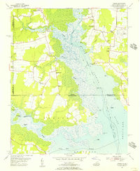
 1948 Ocean View1948 Print · USGSChesapeake Bay's shoreline in the late 1940s is a landscape defined by military bases and growing coastal neighborhoods. Researchers can trace local landmarks like Diamond Springs, Little Creek Mine Base, and the original footprint of Norfolk Airport.
 - 1948 Map of Virginia Beach
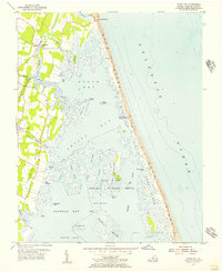
 1948 Virginia Beach1948 Print · USGSCoastal Virginia in the late 1940s is defined by a landscape of military installations and early resort development along the Atlantic. Researchers can trace the Norfolk Southern rail line to Casino Station, locate the grounds of Camp Pendleton, and explore old settlements like Seatack and Atwoodtown.
 - 1948 Map of Princess Anne
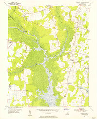
 1948 Princess Anne1948 Print · USGSPrincess Anne and the surrounding Virginia coastal plain appear here in the late 1940s, just as military aviation and rail transit were reshaping the landscape. Researchers can trace ancestral locations through named crossroads and historic sites like London Bridge Church, Whitehart Cem, and the old Norfolk Southern line.
 - 1948 Map of Kempsville
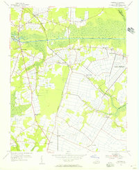
 1948 Kempsville1948 Print · USGSPrincess Anne County in the late nineteen-forties exhibits a mix of rural homesteads and early suburban development linked by the Norfolk Southern line. Researchers can locate family landmarks like Tipperton Place, Bethel Ch and Cem, and the Princess Anne Co Training Sch.
 - 1949 Map of Richmond, 1951 Print
 1949 Richmond1951 Print · USGSCoastal Virginia in the years following World War II remained a landscape of historic river towns and expanding military bases. Genealogists and historians can trace the rail lines of the Southern Ry and locate established landmarks from Camp Lee to the remote reaches of Dragon Swamp.
 - 1952 Map of Cape Henry
 1952 Cape Henry1952 Print · USGSThe Virginia coast at the mouth of the Chesapeake comes alive in this mid-century survey of the Cape Henry region. Researchers can trace the layout of Fort Story, the original boundaries of Seashore State Park, and early bayfront communities like Ocean Park.
 - 1953 Map of Norfolk, 1954 Print
 1953 Norfolk1954 Print · USGSCoastal Virginia and northeastern North Carolina appear here during the post-war industrial boom, showing the critical rail-and-sea connections of Hampton Roads. Genealogists can trace family roots through rural landmarks like Gethsemane Ch, the Caledonia State Prison Farm, and the vast interior of the Dismal Swamp.4 unique versions available
 - 1953 Map of North Bay, 1956 Print
 1953 North Bay1956 Print · USGSVirginia's Atlantic barrier islands and coastal marshes are captured here in the early 1950s. Genealogists and local historians can trace family-named points like Mose Island Point or locate the Little Island Coast Guard Station and Tabernacle Ch.5 unique versions available
 - 1954 Map of Fentress, 1956 Print
 1954 Fentress1956 Print · USGSSoutheastern Virginia at the mid-century shows a landscape shaped by canal traffic and growing military infrastructure. Trace early local roads and family landmarks like Fentress, Hickory Ground, and the Great Bridge Lock.4 unique versions available
 - 1954 Map of Pleasant Ridge, 1956 Print
 1954 Pleasant Ridge1956 Print · USGSCoastal Virginia in the mid-fifties is captured here during a period of rural stability and maritime importance. Genealogists and local historians can trace family-named landmarks and old post offices such as Back Bay (Backbay P O), Dawley Corners, and Camels Chapel.7 unique versions available
 - 1954 Map of Creeds, 1956 Print
 1954 Creeds1956 Print · USGSCoastal Virginia and North Carolina are mapped here in the mid-1950s, showing the intersection of river life and rural farming. Researchers can trace family roots at Kala Ch, find the location of the Creeds Sch, or locate the Creeds Field (Abandoned).4 unique versions available
 - 1954 Map of Knotts Island, 1956 Print
 1954 Knotts Island1956 Print · USGSThe Virginia and North Carolina borderlands come alive in this mid-century coastal survey of the Back Bay. Genealogists can trace family names across Knotts Island, Deal Island, and Simpson Neck, or locate landmarks like Knotts Island Ch.3 unique versions available
 - 1954 Map of Ocean View, 1958 Print
 1954 Ocean View1958 Print · USGSCoastal Virginia in the mid-fifties shows a landscape of rapid growth where the City of Norfolk pushes into the countryside. Genealogists and historians can trace the development of neighborhoods like Camellia Shores and Brandon Place near the Norfolk Municipal Airport.
 - 1955 Map of Virginia Beach, 1958 Print
 1955 Virginia Beach1958 Print · USGSCoastal Virginia in the mid-fifties is seen here as a mix of growing beach resorts and significant Cold War-era military training grounds. Researchers can trace the early layout of Virginia Beach and find local landmarks like Mt Olive Ch, Seatack Sch, and the Coast Guard Station.
Showing maps 1-25 of 71
Top cities of Virginia Beach
Frequently asked questions
- What are the different types of historical maps available for Virginia Beach?
- What is the oldest map of Virginia Beach?
- Where can I purchase historical maps of Virginia Beach for my home or office?
- Where can I download high-res historical maps of Virginia Beach?
- Are there historical topographic maps available for Virginia Beach?
- Is there historical aerial imagery available for Virginia Beach?
- Where are historical maps of Virginia Beach sourced from?