Old Maps of Highland Park, Virginia for Metal Detecting
Plan your next treasure hunt with 15 historic maps of Highland Park. Find old homesites, ghost towns, trails, and gathering spots that may be lost to time — perfect for identifying promising metal detecting locations.
- Locate forgotten sites: Uncover places like long-lost settlements, abandoned rail lines, or gathering spots.
- Plan better hunts: Use map overlays combined with LiDAR or satellite views to narrow in on historically rich areas.
- Made for detectorists: Thousands of hobbyists use these maps to discover relics, coins, and hidden history.
Use these historic maps to boost your research and find new opportunities beneath the surface of Highland Park.
Highland Park, VA maps
(15)- 1893 Map of Luray, 1898 Print
 1893 Luray1898 Print · USGSThe Shenandoah Valley in the 1890s was a land of steep mountain ridges and vital new railways. Genealogists and historians can trace old homesteads and depots along the Shenandoah Valley Railroad or find remote hamlets like Seven Fountains and Browntown.
 - 1905 Map of Luray, 1910 Print
 1905 Luray1910 Print · USGSThe Blue Ridge and Shenandoah Valley are frozen in time just after the turn of the century, showing the critical rail networks and mountain gaps of the period. Genealogists can trace family names and settlements like Luray, Front Royal, and Strasburg along the Shenandoah Valley Railroad.4 unique versions available
 - 1939 Map of Front Royal
 1939 Front Royal1939 Print · USGSThe Blue Ridge foothills and Front Royal are shown here during the late 1930s as the national park and military reservations were being established. Genealogists and historians can trace family locations through numerous rural institutions like Mt Paran Ch, Lottie Sch, and Miller Cem.2 unique versions available
 - 1944 Map of Front Royal
 1944 Front Royal1944 Print · USGSFront Royal and the northern Blue Ridge Mountains appear here during the mid-forties as industrial growth and federal land projects reshaped the valley. Researchers can trace family sites like Miller Cem, explore the early Skyline Drive, and locate schools such as Harmony Hollow Sch.2 unique versions available
 - 1949 Map of Charlottesville
 1949 Charlottesville1949 Print · USGSThe Shenandoah Valley and Blue Ridge appear in the late 1940s as a thriving corridor of rail and river commerce. Researchers can trace the mid-century footprints of Harrisonburg, Staunton, and Culpeper alongside the historic routes of the Southern Railway.2 unique versions available
 - 1956 Map of Charlottesville, 1966 Print
 1956 Charlottesville1966 Print · USGSThe Shenandoah Valley and Blue Ridge are captured in detail during the mid-1960s as the modern interstate system began to emerge. Genealogists and historians can trace rail-connected hubs like Waynesboro or follow the river paths of the Rapidan River and Rivanna River.4 unique versions available
 - 1967 Map of Front Royal, 1968 Print
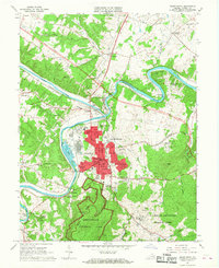 1967 Front Royal1968 Print · USGSFront Royal and the Shenandoah forks were centerpieces of Warren County life in the late sixties. Genealogists and historians can trace family locations near Viscose City, Prospect Hill Cem, and the grounds of Randolph Macon Military Academy.4 unique versions available
 - 1972 Map of Front Royal, 1974 Print
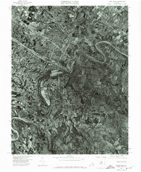 1972 Front Royal1974 Print · USGSWarren County in the early seventies is revealed through this detailed aerial survey of the Shenandoah Valley. Local historians can trace the mid-century footprint of Front Royal and the natural winding paths of the North Fork Shenandoah River and its south fork.
 - 1986 Map of Front Royal
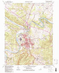
 1986 Front Royal1986 Print · USGSThe northern Shenandoah Valley and the Blue Ridge crest are captured here in the mid-eighties as modern highways began to bypass historic valley towns. Researchers can trace ancestral connections near Peola Mills, navigate the gaps like Manassas Gap, or study the river bends around Luray.3 unique versions available
 - 1994 Map of Front Royal, 1997 Print
 1994 Front Royal1997 Print · USGSFront Royal and its surrounding river valleys are captured here during the mid-nineties, showing the intersection of heavy rail and mountain tourism. Local researchers can trace family names and landmarks like The Ramey Graveyard, Viscose City, and the Randolph Macon Military Academy.
 - 2010 Map of Front Royal, 2010 Print
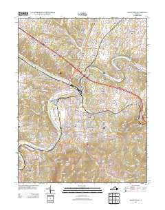
 2010 Front Royal2010 Print · USGSCovers Highland Park, including Front Royal, Shenandoah Shores, and other nearby areas
 - 2013 Map of Front Royal, 2013 Print
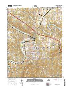
 2013 Front Royal2013 Print · USGSCovers Highland Park, including Front Royal, Shenandoah Shores, and other nearby areas
 - 2016 Map of Front Royal, 2016 Print
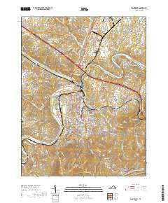
 2016 Front Royal2016 Print · USGSCovers Highland Park, including Front Royal, Shenandoah Shores, and other nearby areas
 - 2019 Map of Front Royal, 2019 Print
 2019 Front Royal2019 Print · USGSCovers Highland Park, including Front Royal, Shenandoah Shores, and other nearby areas
 - 2022 Map of Front Royal, 2022 Print
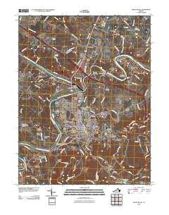
 2022 Front Royal2022 Print · USGSWarren County is shown in modern detail during the early 2020s, centered on the historic river confluence at Front Royal. Trace family history and regional geography through landmarks like Viscose City, the Appalachian National Scenic Trail, and Prospect Hill Cem.
End of results
Showing maps 1-15 of 15
Top cities near Highland Park
- Front Royal historical maps
- Strasburg historical maps
- Shenandoah Farms historical maps
- Stephens City historical maps
- Middletown historical maps
- Apple Mountain Lake historical maps
See more
Frequently asked questions
- What are the different types of historical maps available for Highland Park?
- What is the oldest map of Highland Park?
- Where can I purchase historical maps of Highland Park for my home or office?
- Where can I download high-res historical maps of Highland Park?
- Are there historical topographic maps available for Highland Park?
- Is there historical aerial imagery available for Highland Park?
- Where are historical maps of Highland Park sourced from?