1960s Maps of Ritzville, Washington
Explore 5 historic maps of Ritzville from the 1960s. These maps offer a rare glimpse into what life looked like during the 1960s — showing old roads, neighborhoods, homes, and landmarks that have changed or disappeared over time.
Whether you're researching your family's past, planning a metal detecting trip, or studying how Ritzville's landscape evolved across the 1960s, these high-resolution maps are a powerful tool for exploring the history of this region.
- Focus on a specific era: All maps on this page are from the 1960s, giving you a focused view of this time period.
- See what’s changed: Compare century-old streets, trails, and buildings to today's modern landscape using overlays and satellite layers.
- Research with precision: Use these maps for genealogy, historical research, land use analysis, or educational projects.
- View, download, or print: Maps are fully viewable online in high resolution, and can be downloaded or printed for your own records.
Start exploring Ritzville's history through authentic maps from the 1960s. This is your window into the past.
Ritzville, WA maps
(5)- 1965 Map of Ritzville
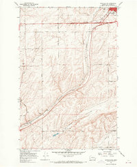
 1965 Ritzville1965 Print · USGSCentral Washington during the mid-sixties shows a landscape shaped by massive irrigation projects and the Cold War. Genealogists and historians can trace rail-town life and military presence through Ephrata Air Base, the Telford Station, and local schools.
 - 1967 Map of Ritzville SW, 1969 Print
 1967 Ritzville SW1969 Print · USGSAdams County in the late 1960s was a hub of transit and ranching, dominated by the coulees and rail lines south of the county seat. Genealogists can trace family landmarks along Dewald Road and Urquhart Road or locate the Paha Cem.2 unique versions available
 - 1967 Map of Ritzville SE, 1969 Print
 1967 Ritzville SE1969 Print · USGSSoutheast of Ritzville in the late 1960s, the landscape is a grid of family-named roads and deep basalt coulees. Trace local history along Urquhart Road, locate the old Shorthorn settlement, and follow the Milwaukee Road railroad tracks.
 - 1967 Map of Ritzville NE, 1970 Print
 1967 Ritzville NE1970 Print · USGSIn the late sixties, the wheat-growing plateaus of Adams County were defined by the rail corridor between Tokio and Ritzville. Genealogists can trace family farm locations via Schafer Road and Neergaard Road, or locate the historic Evergreen Sch and Hawthorne Sch.
 - 1967 Map of Ritzville NW, 1970 Print
 1967 Ritzville NW1970 Print · USGSAdams County agriculture and rail transport meet in the late 1960s across this Scablands landscape. You can trace the Milwaukee Road through Packard or locate family landmarks like Memorial Cemetery and Rosenoff Road.
End of results
Showing maps 1-5 of 5
Top cities near Ritzville
Frequently asked questions
- What are the different types of historical maps available for Ritzville?
- What is the oldest map of Ritzville?
- Where can I purchase historical maps of Ritzville for my home or office?
- Where can I download high-res historical maps of Ritzville?
- Are there historical topographic maps available for Ritzville?
- Is there historical aerial imagery available for Ritzville?
- Where are historical maps of Ritzville sourced from?