
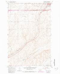
1967 Map of Ritzville SW
USGS Topo · Published 1969About this map
Ritzville stands at the northeastern corner of this Adams County landscape, where the Northern Pacific railroad cuts a diagonal line toward the southwest. The terrain is defined by the distinct dry-waterway carving of Paha Coulee and the broader Mc Elroy Coulee, which contains the intermittent Mc Elroy Lake. This 1960s survey illustrates a region shaped by large-scale agricultural transit and family-named infrastructure. The settlement of Paha serves as a local node, marked by the nearby Paha Cem and several private roads including Dewald Road and Urquhart Road. Evidence of the area's aviation and industrial history is visible through the Municipal Airport near Ritzville and a Gravel Pit located further south along the tracks, reflecting a landscape centered on transport and resource management.
Find a feature on this map
25 named features on this map. Tap any name to fly to it.
Don’t see what you’re looking for? This feature index may not catch every label — zoom into the map to look around manually.
Map Details
Editions of this 1967 Ritzville SW Map
2 editions found
Other maps of this area

1916 · Connell
USGS Topo · 1:125,000

1918 · Connell
USGS Topo · 1:125,000

1923 · Washtucna
USGS Topo · 1:62,500

1925 · Washtucna
USGS Topo · 1:62,500

1953 · Walla Walla
USGS Topo · 1:250,000

1953 · Ritzville
USGS Topo · 1:250,000

1958 · Walla Walla
USGS Topo · 1:250,000

1959 · Ritzville
USGS Topo · 1:250,000

1965 · Ritzville
USGS Topo · 1:250,000

1967 · Ritzville SE
USGS Topo · 1:24,000