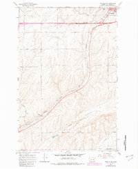
1967 Map of Ritzville SW
USGS Topo · Published 1982About this map
Ritzville serves as the focal point in the northeast corner of this 1960s landscape, where the basalt-carved topography of Adams County reveals a pattern of dry coulees and agricultural development. The Burlington Northern railroad follows the natural grade of Paha Coulee, cutting diagonally across the terrain toward the settlement of Paha. This map illustrates the transition from the municipal center and its Municipal Airport to the outlying sections defined by large-scale farming and family-named routes such as Heineman Road and Sackman Road. The presence of the Paha Cem and the seasonal waters of Mc Elroy Lake reflect the rural heritage and environmental constraints of this region. South of the main rail line, the land is marked by the winding path of Mc Elroy Coulee and a persistent network of unpaved tracks and a Jeep Trail, indicating the more isolated nature of the coulee country.
Find a feature on this map
33 named features on this map. Tap any name to fly to it.
Don’t see what you’re looking for? This feature index may not catch every label — zoom into the map to look around manually.
Map Details
Editions of this 1967 Ritzville SW Map
2 editions found
Other maps of this area

1916 · Connell
USGS Topo · 1:125,000

1918 · Connell
USGS Topo · 1:125,000

1923 · Washtucna
USGS Topo · 1:62,500

1925 · Washtucna
USGS Topo · 1:62,500

1953 · Walla Walla
USGS Topo · 1:250,000

1953 · Ritzville
USGS Topo · 1:250,000

1958 · Walla Walla
USGS Topo · 1:250,000

1959 · Ritzville
USGS Topo · 1:250,000

1965 · Ritzville
USGS Topo · 1:250,000

1967 · Ritzville SW
USGS Topo · 1:24,000