1900s (20th Century) Maps of Benton County, Washington
Explore 98 historic maps of Benton County from the 1900s (20th Century). These maps offer a rare glimpse into what life looked like during the 1900s — showing old roads, neighborhoods, homes, and landmarks that have changed or disappeared over time.
Whether you're researching your family's past, planning a metal detecting trip, or studying how Benton County's landscape evolved across the 1900s, these high-resolution maps are a powerful tool for exploring the history of this region.
- Focus on a specific era: All maps on this page are from the 1900s, giving you a focused view of this time period.
- See what’s changed: Compare century-old streets, trails, and buildings to today's modern landscape using overlays and satellite layers.
- Research with precision: Use these maps for genealogy, historical research, land use analysis, or educational projects.
- View, download, or print: Maps are fully viewable online in high resolution, and can be downloaded or printed for your own records.
Start exploring Benton County's history through authentic maps from the 1900s. This is your window into the past.
Benton County, WA maps
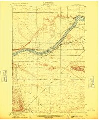
(98)- 1906 Map of Blalock Island, 1954 Print
 1906 Blalock Island1954 Print · USGSThe Columbia River corridor in the early twentieth century served as a vital nexus for Pacific Northwest rail and river trade. Researchers can trace the routes of three major railroads and locate early settlements and landmarks like Irrigon, Blalock Island, and Castle Rock.2 unique versions available
 - 1908 Map of Blalock Island
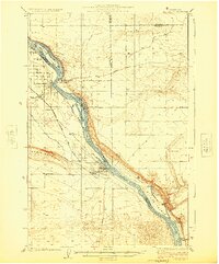
 1908 Blalock Island1908 Print · USGSThe Columbia River frontier of Oregon and Washington is captured here in the years before massive dam projects altered the basin. Researchers can trace the path of the Emigrant Road and locate early settlements like Douglas Morgan P.O., Cecil, and Irrigon.3 unique versions available
 - 1908 Map of Umatilla
 1908 Umatilla1908 Print · USGSEastern Oregon at the turn of the century shows a landscape being transformed by early irrigation and competing rail lines. Genealogists and researchers can trace the growth of Hermiston, Echo, and Pine City or follow the path of the Stage Road and the Furnish Ditch.3 unique versions available
 - 1915 Map of Wallulah
 1915 Wallulah1915 Print · USGSThe convergence of the Snake and Columbia rivers in the mid-1910s reveals a landscape defined by steam power and irrigation. Genealogists and rail historians can trace early settlements like Attalia and Two Rivers alongside the path of the Oregon-Washington RR & Nav Co.
 - 1915 Map of Prosser, 1957 Print
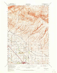
 1915 Prosser1957 Print · USGSThe Yakima Valley thrived as a rail and irrigation hub during the early twentieth century. Researchers can trace the layout of early schools and family-named homesteads like Orchard Ridge School, Snively Ranch, and the town of Prosser.
 - 1916 Map of Coyote Rapids
 1916 Coyote Rapids1916 Print · USGSBenton and Grant counties meet along a wild stretch of the Columbia River during the mid-1910s. Researchers can trace the early railroad stops at Allard and Haven, the site of Coyote Rapids, and the irrigation works of the Benson Ditch.3 unique versions available
 - 1917 Map of Pasco
 1917 Pasco1917 Print · USGSThe confluence of the Columbia and Snake rivers in the early twentieth century shows a region being reshaped by irrigation and rail. Genealogists can trace family holdings and rural schoolhouses like Baxter School, the Farnsworth Ranch, and the Zimmerman Ferry.4 unique versions available
 - 1917 Map of Priest Rapids
 1917 Priest Rapids1917 Print · USGSThe Columbia River bend and the high country of the Rattlesnake Hills are captured here during a period of early ranching and river industry. Genealogists and historians can locate remote outposts like Figure 2 Ranch, the site of Vernita, and the vital Richmond Ferry.2 unique versions available
 - 1917 Map of Prosser
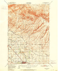
 1917 Prosser1917 Print · USGSBenton and Yakima counties thrive in the late teens as irrigation and rail lines transform the desert floor into a budding agricultural hub. Researchers can trace early family homesteads like Benson Ranch and numerous rural landmarks like Buena Vista School and the Gas Well.2 unique versions available
 - 1918 Map of Wallula, 1942 Print
 1918 Wallula1942 Print · USGSThe river-and-rail hubs of the Walla Walla Valley are captured here as they appeared between the world wars. Researchers can trace the path of the Wallula Ferry, locate early country schools like Frog Hallow School, and follow the complex rail lines through Eureka.2 unique versions available
 - 1924 Map of Hanford
 1924 Hanford1924 Print · USGSThe Columbia River valley in the early 1920s was a landscape of pioneering ranches and riverfront towns long before the atomic age. Genealogists and historians can trace the foundations of Hanford and White Bluffs, or locate rural landmarks like the Brick School and Maplehurst Ranch.2 unique versions available
 - 1935 Map of Pendleton
 1935 Pendleton1935 Print · USGSPendleton and the surrounding Umatilla River valley are captured in the mid-1930s as the region solidified its role as a transportation and agricultural hub. Genealogists can locate numerous named rural schoolhouses such as Campbell Sch and North Yoakum Sch, or trace family sites near the Umatilla Indian Reservation and Cabbage Hill.3 unique versions available
 - 1948 Map of Cairn Hope Peak, 1958 Print
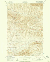 1948 Cairn Hope Peak1958 Print · USGSYakima County ranching lands and military territory are surveyed here shortly after the war. Researchers can trace early family homesteads like Taylor Ranch and Meeboer Ranch, alongside landmarks such as Black Rock Cem.3 unique versions available
 - 1948 Map of Emerson Nipple, 1958 Print
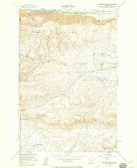 1948 Emerson Nipple1958 Print · USGSThe high desert south of the Columbia River comes into focus in this late-1940s survey, showing a landscape defined by massive ridges and vital water sources. Researchers can locate remote outposts like Roberts Ranch and trace the early route of the Chicago Milwaukee St Paul and Pacific railroad.3 unique versions available
 - 1950 Map of Grandview, 1964 Print
 1950 Grandview1964 Print · USGSThe Yakima Valley thrived as a rail and irrigation hub at mid-century, with the Northern Pacific and Union Pacific lines crossing the basin. Genealogists and researchers can trace family-named sites like Bennett Ranch and Forsell alongside the vital Sunnyside Canal.2 unique versions available
 - 1951 Map of Priest Rapids
 1951 Priest Rapids1951 Print · USGSThe Columbia River and its powerful rapids dominate this landscape during the early fifties, before modern development transformed the river valley. Genealogists and researchers can trace ranching heritage at the Taylor Ranch or locate the Black Rock Cem.
 - 1951 Map of Grandview
 1951 Grandview1951 Print · USGSThe Yakima Valley appears in the early fifties as a hub of irrigation and rail transport. Genealogists and historians can trace the growth of Grandview and Sunnyside alongside landmarks like Bennett Ranch and the Sunnyside Canal.2 unique versions available
 - 1951 Map of Richland, 1955 Print
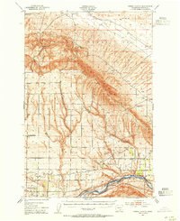
 1951 Richland1955 Print · USGSBenton County undergoes a massive industrial shift during the early Cold War era as the atomic age reshapes the desert landscape. You can trace the early footprint of the Hanford Works, the growth of RICHLAND, and the vital irrigation systems like the Columbia Canal.3 unique versions available
 - 1951 Map of Hanford, 1955 Print
 1951 Hanford1955 Print · USGSThe Columbia River basin in the early fifties shows a landscape reshaped for the atomic era. Genealogists and local historians can trace the foundations of the Hanford Townsite, White Bluffs Townsite, and several family homesteads like Pioneer Ranch.
 - 1951 Map of Corral Canyon, 1955 Print
 1951 Corral Canyon1955 Print · USGSBenton County at the height of the Cold War reveals a landscape shaped by both the atomic age and deep-rooted agriculture. Genealogists and historians can locate family landmarks like Benson Ranch, the settlement of Chaffee (Old Glen), and the vast Hanford Works (A. E. C.) reservation.3 unique versions available
 - 1951 Map of Coyote Rapids, 1955 Print
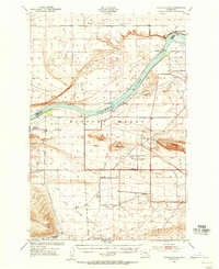 1951 Coyote Rapids1955 Print · USGSIn the early fifties, the Benton County landscape was being reshaped by the industrial expansion of the Atomic Energy Commission. Researchers can trace the early infrastructure of the Hanford Works (A E C) alongside settlements like Wahluke and Allard.
 - 1953 Map of Pendleton, 1957 Print
 1953 Pendleton1957 Print · USGSNortheastern Oregon and the Columbia River frontier are captured here in the early fifties, a time of massive federal infrastructure projects. Researchers can trace the historic route of The Old Oregon Trail as it passes near the Umatilla Ordnance Depot and the new McNary Dam.4 unique versions available
 - 1953 Map of Walla Walla, 1964 Print
 1953 Walla Walla1964 Print · USGSSoutheast Washington enters the atomic and hydroelectric age in the mid-twentieth century as new dams reshape the desert landscape. You can trace the development of the Hanford Works, identify remote rail stops like Novara Siding, and locate the historic Dry Creek Cem.3 unique versions available
 - 1956 Map of Pendleton
 1956 Pendleton1956 Print · USGSNortheastern Oregon’s high plateau and timbered peaks appear here in the mid-fifties, during a time of major military and hydroelectric development. Trace the path of The Old Oregon Trail alongside modern landmarks like McNary Dam and the Umatilla Ordnance Depot.
 - 1958 Map of Walla Walla
 1958 Walla Walla1958 Print · USGSThe Tri-Cities and Walla Walla region are captured here during the mid-century expansion of atomic energy and river infrastructure. Genealogists and historians can trace the early layout of Richland (AEC), the rural Hatton and Washtucna settlements, and landmarks like Palouse Falls State Park.
Showing maps 1-25 of 98
Top cities of Benton County
- Kennewick historical maps
- Richland historical maps
- West Richland historical maps
- Prosser historical maps
- Finley historical maps
- Benton City historical maps
Frequently asked questions
- What are the different types of historical maps available for Benton County?
- What is the oldest map of Benton County?
- Where can I purchase historical maps of Benton County for my home or office?
- Where can I download high-res historical maps of Benton County?
- Are there historical topographic maps available for Benton County?
- Is there historical aerial imagery available for Benton County?
- Where are historical maps of Benton County sourced from?