1990s Maps of Benton County, Washington
Explore 16 historic maps of Benton County from the 1990s. These maps offer a rare glimpse into what life looked like during the 1990s — showing old roads, neighborhoods, homes, and landmarks that have changed or disappeared over time.
Whether you're researching your family's past, planning a metal detecting trip, or studying how Benton County's landscape evolved across the 1990s, these high-resolution maps are a powerful tool for exploring the history of this region.
- Focus on a specific era: All maps on this page are from the 1990s, giving you a focused view of this time period.
- See what’s changed: Compare century-old streets, trails, and buildings to today's modern landscape using overlays and satellite layers.
- Research with precision: Use these maps for genealogy, historical research, land use analysis, or educational projects.
- View, download, or print: Maps are fully viewable online in high resolution, and can be downloaded or printed for your own records.
Start exploring Benton County's history through authentic maps from the 1990s. This is your window into the past.
Benton County, WA maps
(16)- 1992 Map of Richland
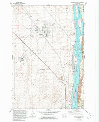
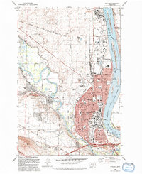 1992 Richland1992 Print · USGSRichland and the edge of the Hanford Site are captured here during the early nineties, showing a city deeply integrated with the Columbia and Yakima rivers. Genealogists and local historians can locate Sunset Mem Gardens and Washington State University, or trace the Richland Terminal RR.
 - 1992 Map of Wallula
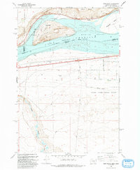
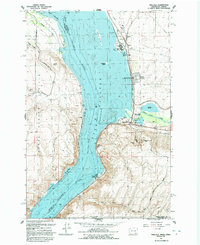 1992 Wallula1992 Print · USGSThe Columbia River corridor near the turn of the 1990s shows a landscape of vital rail lines and river industry. Genealogists and historians can trace the foundations of Wallula and Attalia, and locate landmarks like Wallula Cem and Twin Sisters.
 - 1992 Map of Columbia Point
 1992 Columbia Point1992 Print · USGSThe Tri-Cities area thrived during the early nineties as irrigation and aviation infrastructure transformed the Franklin County desert. Researchers can trace the development of Riverview, the Tri-Cities Airport, and schools like the James W McGee School.
 - 1992 Map of Pasco
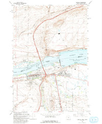
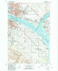 1992 Pasco1992 Print · USGSThe Tri-Cities area thrived during the early nineties as a vital rail and river hub at the meeting of the Columbia and Snake rivers. Genealogists and historians can trace local landmarks like City View Cem, St Patrick Sch, and the Port of Pasco.
 - 1992 Map of Wooden Island
 1992 Wooden Island1992 Print · USGSBenton and Franklin Counties were defined by the intersection of nuclear research and river ecology during the early nineties. Researchers can trace the layout of the Fast Flux Test Facility and the 300 Area alongside Wooded Island.
 - 1992 Map of Kennewick
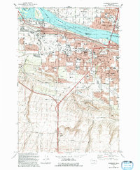 1992 Kennewick1992 Print · USGSKennewick and the Tri-Cities area were in the midst of steady suburban growth during the early nineties. Researchers can trace the development of neighborhoods like West Highlands and South Highlands, and locate landmarks like Vista Field and Kamiakin High Sch.
 - 1992 Map of Humorist
 1992 Humorist1992 Print · USGSWalla Walla County at the confluence of the Snake and Columbia Rivers reveals a landscape shaped by mid-century water management. Researchers can trace the Burlington Northern rail lines and locate the Humorist Cemetery or the Ice Harbor Lock and Dam.
 - 1993 Map of Canoe Ridge
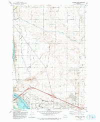
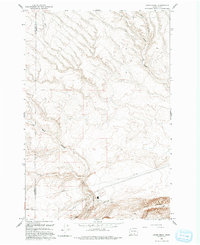 1993 Canoe Ridge1993 Print · USGSThe arid borderlands of Benton and Klickitat counties are captured in the early 1990s, showing a landscape of deep coulees and industrial markers. Trace the path of Dead Canyon and find isolated features like the Landing Strip and Quarry Butte.
 - 1993 Map of West of Paterson
 1993 West of Paterson1993 Print · USGSThe Columbia River frontier of the 1990s reveals a rugged landscape of wildlife refuges and island chains along the Oregon-Washington border. Researchers can trace the river channels around Blalock Islands National Wildlife Refuge, Whitcomb Island, and the ridges above Glade Creek.2 unique versions available
 - 1993 Map of Crow Butte
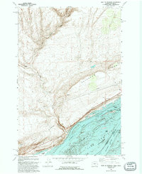
 1993 Crow Butte1993 Print · USGSThe Columbia River frontier of the early nineties is captured here as a landscape of recreation and defense. Trace the development of Crow Butte State Park or the military boundaries of the Naval Weapons Systems Training Facility.
 - 1993 Map of Paterson
 1993 Paterson1993 Print · USGSThe Columbia River shoreline near Paterson and Irrigon is captured in the early nineties, showing a landscape defined by wildlife refuges and river management. Researchers can trace the path of the Old Railroad Grade and explore the islands of the Umatilla National Wildlife Refuge.
 - 1993 Map of Umatilla
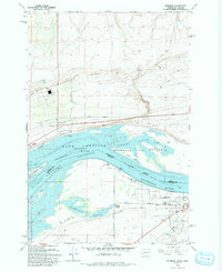
 1993 Umatilla1993 Print · USGSThe Columbia River corridor is captured here in the early nineties, showing the massive engineering of the McNary Lock and Dam and the surrounding irrigation network. Trace the development of Power City, McNary, and the Umatilla shoreline alongside landmarks like Sillusi Butte.
 - 1993 Map of Juniper
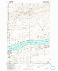
 1993 Juniper1993 Print · USGSThe Columbia River borderlands appear in the early nineties, showing the managed waters of Lake Wallula. Local researchers can trace the settlement at Juniper, the Sand Station Recreation Area, and backcountry landmarks like Cold Springs Canyon.
 - 1993 Map of Irrigon
 1993 Irrigon1993 Print · USGSIrrigon and the Columbia River frontier are captured here in the early nineties as the region balanced agriculture, conservation, and military land use. Genealogists and local historians can locate Houghton Sch, the Desert Lawn Memorial Cem, and the expansive Umatilla Depot Activity.
 - 1993 Map of Boardman
 1993 Boardman1993 Print · USGSBoardman sits along the Columbia River shoreline in the early nineties, where industrial port development meets agricultural irrigation. Trace local genealogy at Riverview Cem or follow the Union Pacific rail lines through Messner and Boardman Junction.
 - 1993 Map of Hat Rock
 1993 Hat Rock1993 Print · USGSThe Columbia River shoreline near the Oregon-Washington border is captured here in the early nineties, showing a landscape defined by water management and transit. Researchers can trace the river's path past Hat Rock State Park, the Union Pacific tracks, and the Cold Springs National Wildlife Refuge.
End of results
Showing maps 1-16 of 16
Top cities of Benton County
- Kennewick historical maps
- Richland historical maps
- West Richland historical maps
- Prosser historical maps
- Finley historical maps
- Benton City historical maps
Frequently asked questions
- What are the different types of historical maps available for Benton County?
- What is the oldest map of Benton County?
- Where can I purchase historical maps of Benton County for my home or office?
- Where can I download high-res historical maps of Benton County?
- Are there historical topographic maps available for Benton County?
- Is there historical aerial imagery available for Benton County?
- Where are historical maps of Benton County sourced from?