1960s Maps of Benton County, Washington
Explore 34 historic maps of Benton County from the 1960s. These maps offer a rare glimpse into what life looked like during the 1960s — showing old roads, neighborhoods, homes, and landmarks that have changed or disappeared over time.
Whether you're researching your family's past, planning a metal detecting trip, or studying how Benton County's landscape evolved across the 1960s, these high-resolution maps are a powerful tool for exploring the history of this region.
- Focus on a specific era: All maps on this page are from the 1960s, giving you a focused view of this time period.
- See what’s changed: Compare century-old streets, trails, and buildings to today's modern landscape using overlays and satellite layers.
- Research with precision: Use these maps for genealogy, historical research, land use analysis, or educational projects.
- View, download, or print: Maps are fully viewable online in high resolution, and can be downloaded or printed for your own records.
Start exploring Benton County's history through authentic maps from the 1960s. This is your window into the past.
Benton County, WA maps
(34)- 1962 Map of Hat Rock, 1963 Print
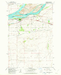
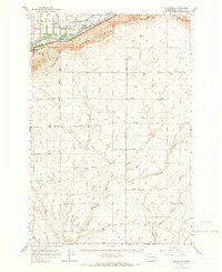
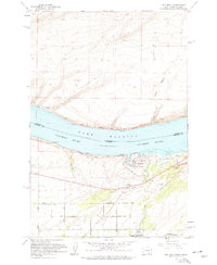 1962 Hat Rock1963 Print · USGSThe Columbia River shoreline in the early sixties reveals a landscape of massive water projects and rail infrastructure. Trace the river's edge through Berrian or explore the landmarks of Hat Rock State Park and the Cold Springs National Wildlife Refuge.3 unique versions available
 - 1962 Map of Canoe Ridge, 1963 Print
 1962 Canoe Ridge1963 Print · USGSBenton and Klickitat counties appear here in the early sixties, showing a landscape defined by industrial utility and topographic relief. Local historians can trace the paths of Waggoner Road, the prominent Dead Canyon, and early utility infrastructure like the southern Pipeline.2 unique versions available
 - 1962 Map of Blalock Island, 1963 Print
 1962 Blalock Island1963 Print · USGSThe Columbia River corridor in the early sixties reveals a landscape of high ridges and mid-river islands. Researchers can trace the Portland Seattle and Spokane railway past Telegraph Island and the rugged cuts of Glade Creek.2 unique versions available
 - 1962 Map of Paterson, 1963 Print
 1962 Paterson1963 Print · USGSThe Columbia River corridor is captured here in the early 1960s, showing the vital rail and water links between Washington and Oregon. Researchers can trace the legacy of the Paterson Ferry, the Spokane Portland and Seattle line, and the Irrigon Cemetery.2 unique versions available
 - 1962 Map of Boardman, 1963 Print
 1962 Boardman1963 Print · USGSBoardman and the Columbia River islands are shown in detail during the early sixties, highlighting the era's critical rail and water transport networks. Researchers can trace family history through rural landmarks like Riverview Cem or explore the vast Boardman Bombing Range and the nearby Fairgrounds.3 unique versions available
 - 1962 Map of Irrigon, 1963 Print
 1962 Irrigon1963 Print · USGSIrrigon and the Columbia River riverfront are captured here in the early sixties, showing the vital intersection of rail and water. Researchers can trace the town's development through Houghton Sch, the local Cem, and the path of the Union Pacific line.3 unique versions available
 - 1962 Map of Crow Butte, 1963 Print
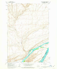
 1962 Crow Butte1963 Print · USGSThe Columbia River serves as a busy transport corridor in the early sixties, marking the border between Washington and Oregon. Researchers can trace historic river landings and military footprints through sites like Toms Camp, Castle Rock, and the Boardman Bombing Range.4 unique versions available
 - 1962 Map of Juniper, 1963 Print
 1962 Juniper1963 Print · USGSThe Columbia River shoreline transformed in the early sixties as Lake Wallula filled the canyon behind the McNary Dam. Trace the historic rail lines of the Union Pacific and Spokane Portland and Seattle flanking the water near Juniper.2 unique versions available
 - 1962 Map of Umatilla, 1963 Print
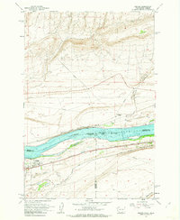
 1962 Umatilla1963 Print · USGSThe Columbia River frontier underwent massive change in the early sixties as hydroelectric power reshaped the landscape. Researchers can trace the mid-century growth of Umatilla and Power City alongside the sprawling infrastructure of McNary Dam.4 unique versions available
 - 1964 Map of Wallula, 1965 Print
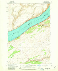
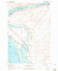
 1964 Wallula1965 Print · USGSThe Columbia River corridor was a bustling hub of rail and river commerce in the mid-1960s as several major railroads converged at the Wallula Gap. Local historians can trace the industrial footprint of Attalia, find the Fort Walla Walla Historical Monument, and locate the Gaging Station Madame Dorion Bridge crossing the Walla Walla River.2 unique versions available
 - 1964 Map of Humorist, 1965 Print
 1964 Humorist1965 Print · USGSThe confluence of the Snake and Columbia rivers in the mid-sixties reveals a landscape reshaped by massive dam projects and wildlife conservation. Trace the intersection of the Northern Pacific rail lines near Humorist or explore the marshlands of the Mc Nary National Wildlife Refuge.2 unique versions available
 - 1964 Map of Johnson Butte, 1966 Print
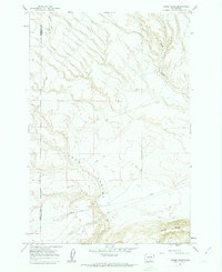
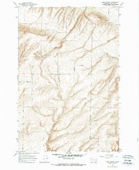
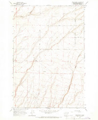
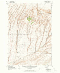 1964 Johnson Butte1966 Print · USGSBenton County in the mid-sixties reveals a landscape of high ridges and deep canyons shaped by dry-land agriculture and early telecommunications. Researchers can locate family landmarks and rural infrastructure like Bofer Well, the Gravel Pit, and the Radio Tower atop Johnson Butte.2 unique versions available
 - 1964 Map of Nine Canyon, 1966 Print
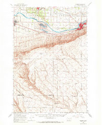
 1964 Nine Canyon1966 Print · USGSBenton County was a landscape of deep canyons and agricultural water systems in the mid-1960s. Researchers can trace historic family-named routes like Mills Road and Albright Road, or locate landmarks such as The Butte and a remote Storage Bin.
 - 1964 Map of Kennewick, 1966 Print
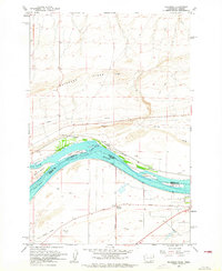
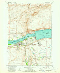
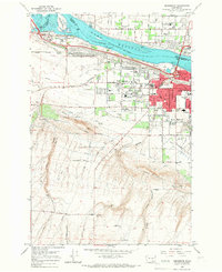 1964 Kennewick1966 Print · USGSThe Tri-Cities area undergoes rapid mid-century expansion where the Yakima and Columbia Rivers meet. Genealogists and local historians can trace suburban growth and irrigation through Kennewick, Riverview Heights Cem, and the Columbia Canal.2 unique versions available
 - 1964 Map of Pasco, 1966 Print
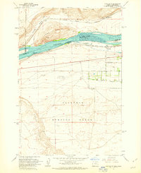
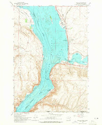
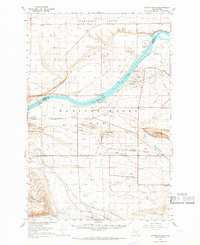
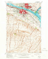 1964 Pasco1966 Print · USGSThe Tri-Cities region underwent significant postwar transformation as irrigation and infrastructure reshaped the Columbia Basin in the 1960s. Researchers can trace the development of Pasco and Kennewick, locating sites like Vista Field and Desert Lawn Memorial Park.
 - 1964 Map of Pasco, 1967 Print
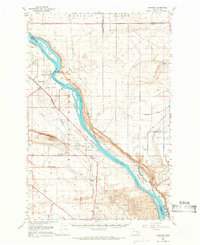
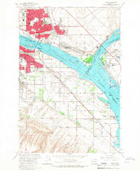 1964 Pasco1967 Print · USGSThe Tri-Cities region underwent significant transformation in the mid-sixties as the newly formed Lake Wallula reshaped the riverfronts. Genealogists and historians can trace the development of PASCO and KENNEWICK, locating long-standing landmarks like City View Cem and the Port of Pasco.2 unique versions available
 - 1965 Map of Whitstran, 1966 Print
 1965 Whitstran1966 Print · USGSBenton County agriculture and transit dominate this mid-century landscape as the Yakima River winds past the growing settlement of Whitstran. Researchers can trace the path of the Northern Pacific railroad or locate family landmarks like the Lenzie Ranch and Davis Ranch.2 unique versions available
 - 1965 Map of Prior Ranch, 1966 Print
 1965 Prior Ranch1966 Print · USGSBenton County ranching country is captured here in the mid-1960s, showing a landscape defined by deep draws and isolated homesteads. Genealogists and researchers can trace family-named routes like Reese Road and Quillen Road to landmarks like the Prior Ranch.
 - 1965 Map of Coyote Rapids, 1966 Print
 1965 Coyote Rapids1966 Print · USGSBenton and Grant Counties are captured here during the mid-sixties, dominated by the secretive landscape of the atomic energy commission. Genealogists and historians can trace the U S Govt Railroad and old river settlements like Allard, Wahluke, and Riverland.2 unique versions available
 - 1965 Map of Eltopia, 1966 Print
 1965 Eltopia1966 Print · USGSFranklin County underwent a radical transformation in the mid-1960s as irrigation projects reshaped the landscape. Researchers can trace early settlements and family landmarks like Timmerman, locate the Markham Sch, and follow the Northern Pacific line through Eltopia.
 - 1965 Map of Hanford, 1966 Print
 1965 Hanford1966 Print · USGSThe mid-sixties Hanford area is captured here during its peak years as a secure federal site. Researchers can trace the U S Government Railroad and locate landmarks like Gable Mountain, Hanford, and the White Bluffs.2 unique versions available
 - 1965 Map of Prosser, 1966 Print
 1965 Prosser1966 Print · USGSThe Yakima Valley in the mid-sixties shows a sophisticated network of canals and rail lines serving the growing communities of Prosser and Grandview. Genealogists and local historians can trace family-named sites like Young Ranch, find Mabton Cem, and locate rural schools such as School No 5.
 - 1965 Map of Prosser SE, 1966 Print
 1965 Prosser SE1966 Print · USGSThe Benton County uplands in the mid-1960s reveal a landscape of deep drainage canyons and isolated ranching outposts. Researchers can trace historic property boundaries and water infrastructure along Young Road and Coyote Canyon, or locate the site of Youngs Ranch.
 - 1965 Map of Priest Rapids, 1966 Print
 1965 Priest Rapids1966 Print · USGSThe Columbia River bend underwent a profound transformation in the 1960s as hydroelectric power and federal projects reshaped the desert landscape. Genealogists and historians can trace family locations like Meeboor Ranch or the Black Rock Cem alongside the massive Priest Rapids Dam.
 - 1965 Map of Whitstran SE, 1966 Print
 1965 Whitstran SE1966 Print · USGSBenton County in the mid-1960s shows a landscape of deep canyons and evolving utility infrastructure. Researchers can trace local property lines and access routes via Horrigan Road, Lenzie Road, and the drainage patterns of Glade Creek.
Showing maps 1-25 of 34
Top cities of Benton County
- Kennewick historical maps
- Richland historical maps
- West Richland historical maps
- Prosser historical maps
- Finley historical maps
- Benton City historical maps
Frequently asked questions
- What are the different types of historical maps available for Benton County?
- What is the oldest map of Benton County?
- Where can I purchase historical maps of Benton County for my home or office?
- Where can I download high-res historical maps of Benton County?
- Are there historical topographic maps available for Benton County?
- Is there historical aerial imagery available for Benton County?
- Where are historical maps of Benton County sourced from?