1940s Maps of Clark County, Washington
Explore 10 historic maps of Clark County from the 1940s. These maps offer a rare glimpse into what life looked like during the 1940s — showing old roads, neighborhoods, homes, and landmarks that have changed or disappeared over time.
Whether you're researching your family's past, planning a metal detecting trip, or studying how Clark County's landscape evolved across the 1940s, these high-resolution maps are a powerful tool for exploring the history of this region.
- Focus on a specific era: All maps on this page are from the 1940s, giving you a focused view of this time period.
- See what’s changed: Compare century-old streets, trails, and buildings to today's modern landscape using overlays and satellite layers.
- Research with precision: Use these maps for genealogy, historical research, land use analysis, or educational projects.
- View, download, or print: Maps are fully viewable online in high resolution, and can be downloaded or printed for your own records.
Start exploring Clark County's history through authentic maps from the 1940s. This is your window into the past.
Clark County, WA maps
(10)- 1940 Map of Lookout Mtn
 1940 Lookout Mtn1940 Print · USGSSkamania County's high country is documented here just before the mid-century, showing a landscape of fire lookouts and forest camps. Researchers can trace early ranger infrastructure and remote sites like the Summit Guard Station, 4th of July Camp, and the Miners site near Copper Creek.
 - 1940 Map of Hillsboro
 1940 Hillsboro1940 Print · USGSThe Tualatin Valley and the Columbia River confluence meet in this 1940 survey of the Hillsboro and North Portland region. Researchers can trace early twentieth-century rail lines like the Oregon Electric or locate historic rural landmarks such as Mountain View Cemetery and the Mason Hill School.
 - 1940 Map of Portland
 1940 Portland1940 Print · USGSThe Portland and Vancouver riverfronts are captured here just before the massive industrial shifts of the mid-century. Genealogists and historians can locate early landmarks like Vancouver Barracks, the University of Portland, and Mundays Ferry.4 unique versions available
 - 1940 Map of La Center
 1940 La Center1940 Print · USGSClark County, Washington, is shown just before the war as a landscape of river-valley farms and timber outposts. Researchers can trace family roots through named intersections like Dollar Corner and Scotton Corner or locate vanished sites like the Ariel School.
 - 1941 Map of Yacolt
 1941 Yacolt1941 Print · USGSIn the early 1940s, Clark County's timber and river country centered on the rail-connected town of Yacolt. Researchers can trace old homesteads and landmarks like Golden Wonder Mine, Riverview School, and the remote Sunset Guard Sta.
 - 1941 Map of St Helens
 1941 St Helens1941 Print · USGSThe Columbia River waterfront near St. Helens was a thriving industrial and agricultural corridor just before the war. Trace old rail stops at Honeymoon Sta, rural schoolhouses like Shilo Basin Sch, and the shifting river islands from Deer Island to Bachelor Island.
 - 1941 Map of Camas
 1941 Camas1941 Print · USGSThe Columbia River corridor is captured here just before the mid-century, showing the bustling industrial towns of Camas and Washougal alongside a rural network of country schools. Genealogists and historians can trace family roots through landmarks like the Silver Star Mine, Cemetery Hill, and dozens of local schoolhouses such as Harmony Sch.
 - 1942 Map of Camas
 1942 Camas1942 Print · USGSThe Columbia River corridor is captured here in the early 1940s, showing the industrial heart of Camas and the rural outskirts of Gresham. Genealogists and historians can trace early schools like Twelvemile Corner Sch and the location of the Silver Star Mine.2 unique versions available
 - 1943 Map of St Helens
 1943 St Helens1943 Print · USGSThe Columbia River corridor during the mid-forties shows a bustling network of riverfront towns and upland settlements. Researchers can trace historic river landings like Caples Landing alongside rural landmarks such as Yankton, Trenholm, and Shilo Basin Sch.
 - 1948 Map of Vancouver, 1957 Print
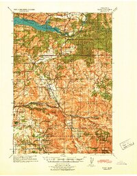
 1948 Vancouver1957 Print · USGSPost-war growth transforms the river valleys of the Pacific Northwest as the timber and rail economy thrives. Trace family roots in Tillamook or Oregon City, and locate vanished landmarks like the spit at Bayocean or the Skamania Mine.
End of results
Showing maps 1-10 of 10
Top cities of Clark County
- Vancouver historical maps
- Camas historical maps
- Battle Ground historical maps
- Washougal historical maps
- Ridgefield historical maps
- La Center historical maps
See more
Frequently asked questions
- What are the different types of historical maps available for Clark County?
- What is the oldest map of Clark County?
- Where can I purchase historical maps of Clark County for my home or office?
- Where can I download high-res historical maps of Clark County?
- Are there historical topographic maps available for Clark County?
- Is there historical aerial imagery available for Clark County?
- Where are historical maps of Clark County sourced from?