1980s Maps of Clark County, Washington
Explore 9 historic maps of Clark County from the 1980s. These maps offer a rare glimpse into what life looked like during the 1980s — showing old roads, neighborhoods, homes, and landmarks that have changed or disappeared over time.
Whether you're researching your family's past, planning a metal detecting trip, or studying how Clark County's landscape evolved across the 1980s, these high-resolution maps are a powerful tool for exploring the history of this region.
- Focus on a specific era: All maps on this page are from the 1980s, giving you a focused view of this time period.
- See what’s changed: Compare century-old streets, trails, and buildings to today's modern landscape using overlays and satellite layers.
- Research with precision: Use these maps for genealogy, historical research, land use analysis, or educational projects.
- View, download, or print: Maps are fully viewable online in high resolution, and can be downloaded or printed for your own records.
Start exploring Clark County's history through authentic maps from the 1980s. This is your window into the past.
Clark County, WA maps
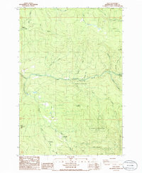
(9)- 1983 Map of Cougar
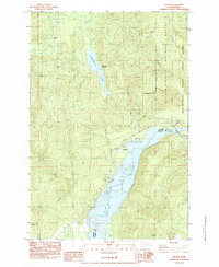 1983 Cougar1983 Print · USGSThe community of Cougar is captured here in the early eighties, positioned at the critical junction of the Gifford Pinchot National Forest and the Mount St Helens vicinity. Modern researchers can trace the development of lakeside recreation at Yale Park, Cougar Park, and the Beaver Bay Park Campground.
 - 1984 Map of Mt Mitchell
 1984 Mt Mitchell1984 Print · USGSThe Cascades of Skamania County appear in the mid-eighties as a landscape of hydroelectric power and volcanic geology. You can trace the Lewis River industrial sites like the Log Sorting Yard or explore geologic landmarks including Ape Cave and Mount Mitchell.
 - 1986 Map of Gumboot Mtn
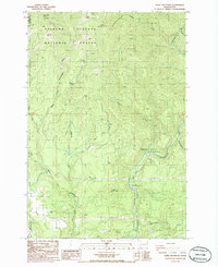
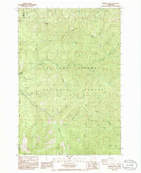 1986 Gumboot Mtn1986 Print · USGSSkamania and Clark Counties are shown in the mid-1980s as a landscape of timber and mountain peaks within the Gifford Pinchot National Forest. Researchers can locate old mining sites like Miners Mines and topographic landmarks including Saturday Rock and Silver Star Mountain.2 unique versions available
 - 1986 Map of Yale Dam
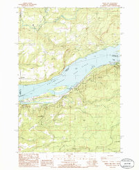
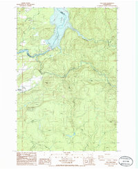 1986 Yale Dam1986 Print · USGSHydroelectric development on the Lewis River defined this corner of Clark County in the 1980s. Researchers can trace the layout of Yale and Chelatchie, locate the local cemetery, and explore the infrastructure surrounding Yale Dam and Speelyai Park.2 unique versions available
 - 1986 Map of Siouxon Peak
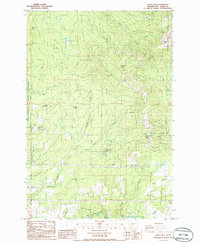
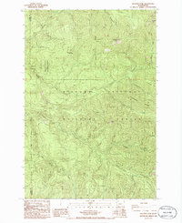 1986 Siouxon Peak1986 Print · USGSThe southern Washington Cascades appear in the mid-1980s as a managed landscape of timber and trails. Collectors can trace the remote Hickmans Cabin, industrial sites like the Quarry, and the high ridges of Siouxon Peak and Calamity Pk.2 unique versions available
 - 1986 Map of Dole
 1986 Dole1986 Print · USGSThe East Fork Lewis River basin in the mid-eighties shows a landscape transition from timber production to state and national park management. Genealogists and outdoor historians can locate the Dole settlement or trace landmarks like Horseshoe Falls and Yacolt Reservoir.2 unique versions available
 - 1986 Map of Bobs Mountain
 1986 Bobs Mountain1986 Print · USGSSkamania County's forested ridges and river valleys are captured here in the mid-1980s during a period of active timber and land management. Researchers can locate remote industrial sites like the Skamania Mine and Last Chance Mine or archaeological landmarks like the Silver Star Indian Pits.2 unique versions available
 - 1986 Map of Bridal Veil
 1986 Bridal Veil1986 Print · USGSThe Columbia River Gorge in the mid-1980s reveals a landscape of dramatic riverside cliffs and historic parklands. Researchers can trace the development of riverfront settlements like Prindle and Bridal Veil or locate landmarks like Rooster Rock and the Pillars of Hercules.2 unique versions available
 - 1986 Map of Larch Mtn
 1986 Larch Mtn1986 Print · USGSClark County's rugged eastern highlands are captured here in the mid-1980s, where public forests meet institutional and military lands. Trace the remote network of 4WD trails leading to landmarks like Larch Mtn, Sturgeon Rock, and the Larch Corrections Center.2 unique versions available
End of results
Showing maps 1-9 of 9
Top cities of Clark County
- Vancouver historical maps
- Camas historical maps
- Battle Ground historical maps
- Washougal historical maps
- Ridgefield historical maps
- La Center historical maps
See more
Frequently asked questions
- What are the different types of historical maps available for Clark County?
- What is the oldest map of Clark County?
- Where can I purchase historical maps of Clark County for my home or office?
- Where can I download high-res historical maps of Clark County?
- Are there historical topographic maps available for Clark County?
- Is there historical aerial imagery available for Clark County?
- Where are historical maps of Clark County sourced from?