1990s Maps of Clark County, Washington
Explore 18 historic maps of Clark County from the 1990s. These maps offer a rare glimpse into what life looked like during the 1990s — showing old roads, neighborhoods, homes, and landmarks that have changed or disappeared over time.
Whether you're researching your family's past, planning a metal detecting trip, or studying how Clark County's landscape evolved across the 1990s, these high-resolution maps are a powerful tool for exploring the history of this region.
- Focus on a specific era: All maps on this page are from the 1990s, giving you a focused view of this time period.
- See what’s changed: Compare century-old streets, trails, and buildings to today's modern landscape using overlays and satellite layers.
- Research with precision: Use these maps for genealogy, historical research, land use analysis, or educational projects.
- View, download, or print: Maps are fully viewable online in high resolution, and can be downloaded or printed for your own records.
Start exploring Clark County's history through authentic maps from the 1990s. This is your window into the past.
Clark County, WA maps
(18)- 1990 Map of Sauvie Island, 1995 Print
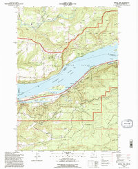
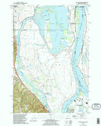 1990 Sauvie Island1995 Print · USGSSauvie Island and the Columbia River confluence appear here in the early 1990s, where river hydrology meets the Tualatin foothills. Trace the historical tracks of the Burlington Northern RR through Burlington and Holbrook, or explore the old river landings at Chapman Landing and Morgan Landing.
 - 1990 Map of Saint Helens, 1995 Print
 1990 Saint Helens1995 Print · USGSThe Columbia River corridor near the Oregon-Washington border is captured here during the mid-nineties, showing the evolving relationship between industry and wildlife preservation. Researchers can trace the Portland & Western RR through Warren or locate local landmarks like Warrior Rock and the Scappoose Industrial Airpark.
 - 1990 Map of Lacamas Creek, 1995 Print
 1990 Lacamas Creek1995 Print · USGSNortheast of Vancouver in the early nineties, this area shows a landscape defined by military land and rural crossroads. Genealogists and researchers can trace local landmarks from Hockinson and Fern Prairie to industrial sites like the English Pit and Grove Field.
 - 1990 Map of Ridgefield, 1995 Print
 1990 Ridgefield1995 Print · USGSNear the confluence of the Lewis and East Fork Lewis Rivers in the early 1990s, this area reflects a balance of rural homesteads and protected wetlands. Researchers can locate family landmarks like Mount Zion Cemetery and historic routes such as Pekin Ferry Road.
 - 1990 Map of Portland, 1995 Print
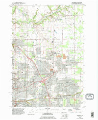
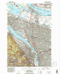 1990 Portland1995 Print · USGSPortland and Vancouver are captured at a point of high urban density and industrial maturity in the 1990s. Genealogists and historians can trace neighborhood evolutions through landmarks like Lone Fir Cemetery, Albina, and the historic Fort Vancouver National Historic Site.
 - 1990 Map of Vancouver, 1995 Print
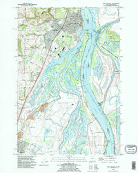
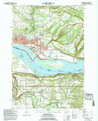
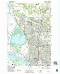 1990 Vancouver1995 Print · USGSVancouver and its Columbia River waterfront are captured here in the 1990s as the city expanded northward toward Salmon Creek. Researchers can locate family plots at Salmon Creek Cem, explore the grounds of Clark College, or trace the rail lines through Vancouver Junction.
 - 1990 Map of Yacolt, 1995 Print
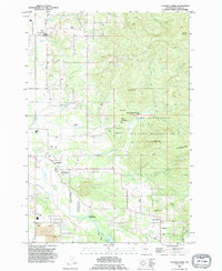
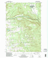 1990 Yacolt1995 Print · USGSYacolt and the East Fork Lewis River are captured here during the 1990s as the region balanced timber heritage with growing recreation. Genealogists and researchers can trace the locations of the Gravel Point Cemetery, Finn Hill Cemetery, and the old settlement of Venersborg.
 - 1990 Map of Mount Tabor, 1995 Print
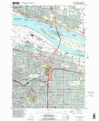 1990 Mount Tabor1995 Print · USGSEastern Portland and the Columbia River riverfront are captured here in the early nineties, showing the city's growth toward the airport. Researchers can trace neighborhood development near Mount Tabor, locate Rose City Cemetery, or study the Union Pacific rail corridor.
 - 1990 Map of Orchards, 1995 Print
 1990 Orchards1995 Print · USGSGreater Vancouver and the Fourth Plains area appear here in the early nineties as the suburban grid expands into traditional farmland. Genealogists and local researchers can locate family sites at St Johns Cem, Elim Ch, and the long-established settlement of Brush Prairie.
 - 1990 Map of Battle Ground, 1995 Print
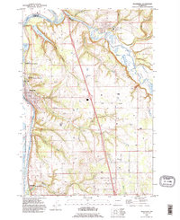
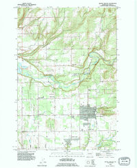 1990 Battle Ground1995 Print · USGSBattle Ground and its surrounding Clark County rural communities are captured here in the early nineties during a period of steady growth. Researchers can trace ancestral roots and old property lines near Dublin Cemetery, Charter Oak, and the distinctive family-named crossroads of King Corner.
 - 1990 Map of Woodland, 1995 Print
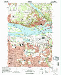
 1990 Woodland1995 Print · USGSWoodland and the Lewis River valley are captured in the early nineties, showing a landscape of riverfront commerce and rising timberlands. Researchers can locate family landmarks such as Highland Cem, Abel Cem, and the community gathering point at Finn Hall.
 - 1993 Map of Camas, 1996 Print
 1993 Camas1996 Print · USGSThe Columbia River corridor in the 1990s reveals a bustling landscape of industry and suburban growth spanning the Washington and Oregon border. Genealogists and researchers can trace the development of Camas and Gresham, locating landmarks like Knight Cem, the Aluminum Plant, and Mount Hood Community College.
 - 1994 Map of Bridal Veil, 1996 Print
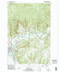
 1994 Bridal Veil1996 Print · USGSThe Columbia River Gorge in the mid-nineties shows a landscape defined by dramatic cliffs and the legacy of early highway engineering. Researchers can trace the paths to iconic sites like Vista House, Rooster Rock, and the historic settlement of Bridal Veil.
 - 1994 Map of Washougal, 1996 Print
 1994 Washougal1996 Print · USGSThe Columbia River corridor comes into focus in the mid-1990s as it divides Washington and Oregon. Researchers can trace local landmarks like Washougal Memorial Cemetery, the Grange Hall, and Corbett Station.
 - 1998 Map of Siouxon Peak, 2003 Print
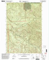 1998 Siouxon Peak2003 Print · USGSThe southern Cascade Range on the Clark and Skamania county line is shown here in the late 1990s as a hub of forest management and recreation. Trace the paths of the Horseshoe Ridge Trail and find landmarks like Siouxon Peak, Calamity Peak, and the Canyon Creek Campground.
 - 1998 Map of Mt Mitchell, 2003 Print
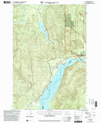
 1998 Mt Mitchell2003 Print · USGSThe Gifford Pinchot National Forest meets the Mount St Helens National Volcanic Monument in the late nineties as this region balances power generation and volcanic history. Trace the complex Ape Cave system, the industrial footprint of the Swift Dam, and high points like Mount Mitchell.
 - 1998 Map of Cougar, 2003 Print
 1998 Cougar2003 Print · USGSNear the turn of the millennium, the settlement of Cougar stood as a key access point to the volcanic wilderness and the Lewis River valley. Researchers can trace local landmarks like the Mobile Home Park and recreation sites such as Cougar Park and Merrill Lake.
 - 1998 Map of Gumboot Mountain, 2003 Print
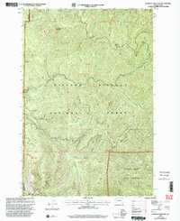 1998 Gumboot Mountain2003 Print · USGSThe high Cascades near the Skamania and Clark County line are captured here in the late 1990s as a landscape of timber and recreation. Researchers can trace the winding East Fork Lewis River to find old Mines, the Sunset Campground, and the peaks of Silver Star Mountain.
End of results
Showing maps 1-18 of 18
Top cities of Clark County
- Vancouver historical maps
- Camas historical maps
- Battle Ground historical maps
- Washougal historical maps
- Ridgefield historical maps
- La Center historical maps
See more
Frequently asked questions
- What are the different types of historical maps available for Clark County?
- What is the oldest map of Clark County?
- Where can I purchase historical maps of Clark County for my home or office?
- Where can I download high-res historical maps of Clark County?
- Are there historical topographic maps available for Clark County?
- Is there historical aerial imagery available for Clark County?
- Where are historical maps of Clark County sourced from?