1980s Maps of Columbia County, Washington
Explore 9 historic maps of Columbia County from the 1980s. These maps offer a rare glimpse into what life looked like during the 1980s — showing old roads, neighborhoods, homes, and landmarks that have changed or disappeared over time.
Whether you're researching your family's past, planning a metal detecting trip, or studying how Columbia County's landscape evolved across the 1980s, these high-resolution maps are a powerful tool for exploring the history of this region.
- Focus on a specific era: All maps on this page are from the 1980s, giving you a focused view of this time period.
- See what’s changed: Compare century-old streets, trails, and buildings to today's modern landscape using overlays and satellite layers.
- Research with precision: Use these maps for genealogy, historical research, land use analysis, or educational projects.
- View, download, or print: Maps are fully viewable online in high resolution, and can be downloaded or printed for your own records.
Start exploring Columbia County's history through authentic maps from the 1980s. This is your window into the past.
Columbia County, WA maps
(9)- 1980 Map of Walla Walla
 1980 Walla Walla1980 Print · USGSThe Walla Walla Valley in the early eighties shows a landscape of deep-rooted agriculture and massive hydroelectric development. Researchers can trace the rail junctions at Wallula Junction, visit the historic Fort Walla Walla, or locate old landmarks like the Mountain View Cem.2 unique versions available
 - 1981 Map of Starbuck East
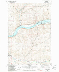 1981 Starbuck East1981 Print · USGSThe Snake River corridor in southeastern Washington comes alive in this early 1980s survey, showing the impact of damming and rail transport on the landscape. Local historians can trace the Union Pacific route through Starbuck and Riparia, alongside agricultural landmarks like Grain Elevators.
 - 1981 Map of Starbuck West
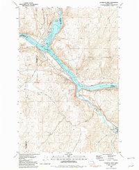 1981 Starbuck West1981 Print · USGSThe confluence of the Palouse and Snake Rivers is captured here in the early eighties, showcasing a landscape shaped by water and rail. Trace the Union Pacific line past Starbuck or locate the Marmes Rock Shelter and Old Bones Cem.
 - 1981 Map of Dodge
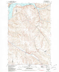 1981 Dodge1981 Print · USGSThe riverfront and rail corridors of Garfield County are captured here in the early eighties. Researchers can trace the Union Pacific line through the Pataha Valley or locate the Port of Garfield and the settlement of Dodge.
 - 1981 Map of Delaney
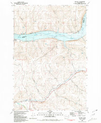 1981 Delaney1981 Print · USGSSoutheastern Washington's river valleys and wheat country are captured here in the early 1980s as the rail-and-river economy matured. Trace the Union Pacific line through Delaney, locate the Grain Elevator, or find the Little Goose Landing Strip near the Snake River.
 - 1981 Map of Clarkston
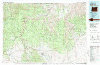
 1981 Clarkston1981 Print · USGSNorthwestern river life and mountain terrain meet in the early eighties as the Snake River carves through the landscape. Researchers can trace rail history along the Camas Prairie Railroad and locate smaller settlements like Peola and Anatone.2 unique versions available
 - 1982 Map of Pullman
 1982 Pullman1982 Print · USGSThe Palouse region and Snake River valley are shown in the early eighties as the river navigation system matured. Trace the rail lines of the Union Pacific, locate rural centers like Johnson and Colton, and see the impact of the Lower Granite Dam.
 - 1982 Map of Wallowa, 1983 Print
 1982 Wallowa1983 Print · USGSNortheast Oregon's rugged canyon country is captured here in the early eighties, showing a landscape defined by the Grande Ronde River and its high plateaus. Researchers can trace the Union Pacific line through Rondowa or locate vanished sites like Maxville and Palmer Junction.2 unique versions available
 - 1983 Map of Connell
 1983 Connell1983 Print · USGSEastern Washington's coulee country is captured here in the early eighties as a landscape of remote rail junctions and massive river engineering. Trace family roots in Connell or Kahlotus, and follow old transport lines like the Old Lind Road Grade and Burlington Northern tracks.
End of results
Showing maps 1-9 of 9
Top cities of Columbia County
Frequently asked questions
- What are the different types of historical maps available for Columbia County?
- What is the oldest map of Columbia County?
- Where can I purchase historical maps of Columbia County for my home or office?
- Where can I download high-res historical maps of Columbia County?
- Are there historical topographic maps available for Columbia County?
- Is there historical aerial imagery available for Columbia County?
- Where are historical maps of Columbia County sourced from?