1970s Maps of Cowlitz County, Washington
Explore 8 historic maps of Cowlitz County from the 1970s. These maps offer a rare glimpse into what life looked like during the 1970s — showing old roads, neighborhoods, homes, and landmarks that have changed or disappeared over time.
Whether you're researching your family's past, planning a metal detecting trip, or studying how Cowlitz County's landscape evolved across the 1970s, these high-resolution maps are a powerful tool for exploring the history of this region.
- Focus on a specific era: All maps on this page are from the 1970s, giving you a focused view of this time period.
- See what’s changed: Compare century-old streets, trails, and buildings to today's modern landscape using overlays and satellite layers.
- Research with precision: Use these maps for genealogy, historical research, land use analysis, or educational projects.
- View, download, or print: Maps are fully viewable online in high resolution, and can be downloaded or printed for your own records.
Start exploring Cowlitz County's history through authentic maps from the 1970s. This is your window into the past.
Cowlitz County, WA maps
(8)- 1971 Map of Ariel, 1973 Print
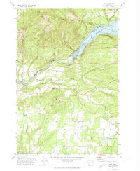 1971 Ariel1973 Print · USGSSouthwest Washington's hydroelectric and timber heartland is captured here in the early 1970s. Researchers can locate family landmarks like Mtn View Cem, trace the community around Green Mountain Sch, and see industrial sites from the State Fish Hatchery to the Merwin Dam.2 unique versions available
 - 1971 Map of Woodland, 1973 Print
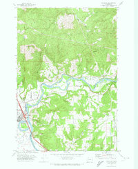 1971 Woodland1973 Print · USGSWoodland and the Lewis River valley are shown in the early seventies as the area balanced river-based industry with growing rural settlements. Genealogists can locate family names and sites like Highland Cem, Abel Cem, and the Finn Hall community.
 - 1971 Map of Amboy, 1973 Print
 1971 Amboy1973 Print · USGSIn the early seventies, the rural landscape of Clark County centered on the junction of Amboy and the timber-rich foothills of Green Mountain. Genealogists and historians can trace local family landmarks and infrastructure like the Cem, Chelatchie settlement, and the Landing Strip at the edge of Chelatchie Prairie.2 unique versions available
 - 1975 Map of Spirit Lake SW, 1980 Print
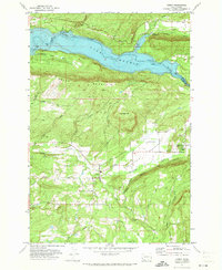
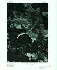
 1975 Spirit Lake SW1980 Print · USGSCovers Cowlitz County, including Skamania County, United States, and other nearby areas
 - 1975 Map of Cougar SE, 1980 Print
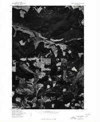
 1975 Cougar SE1980 Print · USGSCovers Cowlitz County, including Cougar, Clark County, and other nearby areas
 - 1975 Map of Elk Rock SE, 1980 Print
 1975 Elk Rock SE1980 Print · USGSCovers Cowlitz County, including United States, Washington, and other nearby areas
 - 1975 Map of Cougar NE, 1980 Print
 1975 Cougar NE1980 Print · USGSCovers Cowlitz County, including United States, Washington, and other nearby areas
 - 1979 Map of Vancouver, 1980 Print
 1979 Vancouver1980 Print · USGSThe Portland and Vancouver metropolitan area is captured here in the late seventies, showing the dense nexus of river, rail, and air transit. Genealogists and local historians can trace the footprints of Vancouver Barracks, Lincoln Memorial Park Cem, and the old rail lines of the Burlington Northern.2 unique versions available
End of results
Showing maps 1-8 of 8
Top cities of Cowlitz County
- Longview historical maps
- Kelso historical maps
- Woodland historical maps
- Kalama historical maps
- Castle Rock historical maps
Frequently asked questions
- What are the different types of historical maps available for Cowlitz County?
- What is the oldest map of Cowlitz County?
- Where can I purchase historical maps of Cowlitz County for my home or office?
- Where can I download high-res historical maps of Cowlitz County?
- Are there historical topographic maps available for Cowlitz County?
- Is there historical aerial imagery available for Cowlitz County?
- Where are historical maps of Cowlitz County sourced from?