2000s (21st Century) Maps of Orondo, Washington
Explore 2 historic maps of Orondo from the 2000s (21st Century). These maps offer a rare glimpse into what life looked like during the 2000s — showing old roads, neighborhoods, homes, and landmarks that have changed or disappeared over time.
Whether you're researching your family's past, planning a metal detecting trip, or studying how Orondo's landscape evolved across the 2000s, these high-resolution maps are a powerful tool for exploring the history of this region.
- Focus on a specific era: All maps on this page are from the 2000s, giving you a focused view of this time period.
- See what’s changed: Compare century-old streets, trails, and buildings to today's modern landscape using overlays and satellite layers.
- Research with precision: Use these maps for genealogy, historical research, land use analysis, or educational projects.
- View, download, or print: Maps are fully viewable online in high resolution, and can be downloaded or printed for your own records.
Start exploring Orondo's history through authentic maps from the 2000s. This is your window into the past.
Orondo, WA maps
(2)- 2003 Map of Entiat, 2006 Print
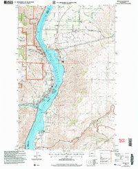 2003 Entiat2006 Print · USGSThe Columbia River corridor in the early 2000s reveals a landscape of orchard communities and rugged river breaks. Genealogists and local historians can locate the Orondo School, Brays Landing Cemetery, and landmarks like the Grange Hall in Orondo.
 - 2023 Map of Entiat, 2023 Print
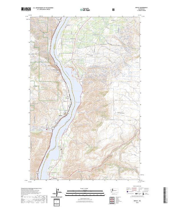 2023 Entiat2023 Print · USGSThe Columbia River separates the Wenatchee National Forest from the Waterville Plateau in this modern survey. Genealogists and historians can locate Entiat and Orondo, and trace landmarks like the Orondo Community Cem and Ribbon Cliff.
End of results
Showing maps 1-2 of 2
Top cities near Orondo
- Wenatchee historical maps
- East Wenatchee historical maps
- Chelan historical maps
- Cashmere historical maps
- Waterville historical maps
- Entiat historical maps
Frequently asked questions
- What are the different types of historical maps available for Orondo?
- What is the oldest map of Orondo?
- Where can I purchase historical maps of Orondo for my home or office?
- Where can I download high-res historical maps of Orondo?
- Are there historical topographic maps available for Orondo?
- Is there historical aerial imagery available for Orondo?
- Where are historical maps of Orondo sourced from?