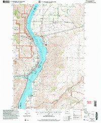
2003 Map of Entiat
USGS Topo · Published 2006About this map
The Columbia River - Lake Entiat dominates this landscape, serving as the border between Chelan and Douglas counties. Along the western bank, the town of Entiat is situated at the confluence with the Entiat River, characterized by civic spaces like Will Risk Memorial Park and Silico Saska Park. To the east, the Waterville Plateau rises sharply, where the community of Orondo is established near agricultural infrastructure including the Orondo School and the Grange Hall.
Find a feature on this map
62 named features on this map. Tap any name to fly to it.
Don’t see what you’re looking for? This feature index may not catch every label — zoom into the map to look around manually.
Map Details
Editions of this 2003 Entiat Map
This is the sole edition of this map. No revisions or reprints were ever made.
Other maps of this area

1901 · Chelan
USGS Topo · 1:125,000

1957 · Wenatchee
USGS Topo · 1:250,000

1968 · Chelan
USGS Topo · 1:24,000

1968 · Orondo
USGS Topo · 1:24,000

1968 · Waterville
USGS Topo · 1:24,000

1968 · Entiat
USGS Topo · 1:24,000

1968 · Ardenvoir
USGS Topo · 1:24,000

1968 · Baldy Mtn
USGS Topo · 1:24,000
1968 · Douglas
USGS Topo · 1:24,000

1968 · Winesap
USGS Topo · 1:24,000