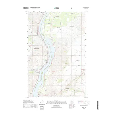
2020 Map of Entiat
USGS Topo · Published 2020About this map
Entiat and Orondo flank the Columbia River corridor in this 2020 study, where the Chelan and Douglas County line runs through the center of Lake Entiat. The landscape is defined by the dramatic transition from the orchards and plateaus of the east to the protected slopes of the Wenatchee National Forest in the west. Significant geological landmarks like Ribbon Cliff and Earthquake Point overlook the water, while the Entiat River and the Entiat Ditch support the agricultural character of the Entiat Valley. On the eastern shore, the Orondo Community Cem sits near the base of Pine Canyon, illustrating the long-standing settlement pattern along the river. The map also captures the varied terrain of the Waterville Plateau and the deeply incised paths of Corbaley Canyon and Browns Canyon, providing a clear view of the area's modern infrastructure and historical land use.
Find a feature on this map
60 named features on this map. Tap any name to fly to it.
Don’t see what you’re looking for? This feature index may not catch every label — zoom into the map to look around manually.
Map Details
Editions of this 2020 Entiat Map
This is the sole edition of this map. No revisions or reprints were ever made.
Other maps of this area

1901 · Chelan
USGS Topo · 1:125,000

1957 · Wenatchee
USGS Topo · 1:250,000

1968 · Chelan
USGS Topo · 1:24,000

1968 · Orondo
USGS Topo · 1:24,000

1968 · Waterville
USGS Topo · 1:24,000

1968 · Entiat
USGS Topo · 1:24,000

1968 · Ardenvoir
USGS Topo · 1:24,000

1968 · Baldy Mtn
USGS Topo · 1:24,000
1968 · Douglas
USGS Topo · 1:24,000

1968 · Winesap
USGS Topo · 1:24,000