1990s Maps of Garfield County, Washington
Explore 9 historic maps of Garfield County from the 1990s. These maps offer a rare glimpse into what life looked like during the 1990s — showing old roads, neighborhoods, homes, and landmarks that have changed or disappeared over time.
Whether you're researching your family's past, planning a metal detecting trip, or studying how Garfield County's landscape evolved across the 1990s, these high-resolution maps are a powerful tool for exploring the history of this region.
- Focus on a specific era: All maps on this page are from the 1990s, giving you a focused view of this time period.
- See what’s changed: Compare century-old streets, trails, and buildings to today's modern landscape using overlays and satellite layers.
- Research with precision: Use these maps for genealogy, historical research, land use analysis, or educational projects.
- View, download, or print: Maps are fully viewable online in high resolution, and can be downloaded or printed for your own records.
Start exploring Garfield County's history through authentic maps from the 1990s. This is your window into the past.
Garfield County, WA maps
(9)- 1995 Map of Pinkham Butte, 1998 Print
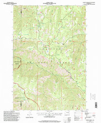
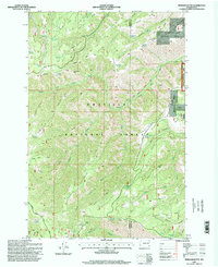 1995 Pinkham Butte1998 Print · USGSHigh-country ridges and forest trails define this Garfield County landscape in the mid-1990s. Researchers can trace the Government Trail and locate family-named landmarks like Pinkham Butte, Jump off Joe Point, and Wickiup Spring.
 - 1995 Map of Hopkins Ridge, 1998 Print
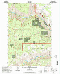
 1995 Hopkins Ridge1998 Print · USGSSoutheast Washington’s Blue Mountain foothills were managed for conservation and wildlife in the mid-nineties, centering on the Tucannon River corridor. Genealogists and researchers can trace local landmarks like the Cem near the river or the Tucannon Guard Station and Fish Hatchery.
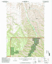
 - 1995 Map of Diamond Peak, 1998 Print
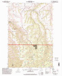
 1995 Diamond Peak1998 Print · USGSGarfield and Columbia counties in the mid-1990s are shown here as a wilderness of high ridges and isolated forest outposts. Researchers can trace remote mountain activity through features like Kelly Camp, the F Kessler Ranch, and the Sheephead Corral.
 - 1995 Map of Peola, 1998 Print
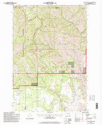
 1995 Peola1998 Print · USGSThe settlement of Peola sits high on the plateau in the 1990s, surrounded by a complex network of ridges and gulches. Researchers can trace local history through the Pioneer Cemetery, named water sources like Iron Springs, and the winding Pow Wah Kee Road.
 - 1995 Map of Stentz Spring, 1998 Print
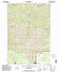
 1995 Stentz Spring1998 Print · USGSThe high ridges of Garfield and Columbia Counties are captured here in the mid-1990s as the wilderness boundary meets the national forest. Researchers can trace seasonal encampments like Powell Camp and administrative landmarks such as the Clearwater Guard Station.
 - 1995 Map of Eden, 1998 Print
 1995 Eden1998 Print · USGSThe Oregon-Washington borderlands near the Grande Ronde come alive in the mid-nineties, showing a landscape of wilderness and forestry. Genealogists and hikers can trace the Eden Cemetery, locate the Eden Community Hall, and follow the Smooth Ridge Trail through the Wenaha-Tucannon Wilderness.
 - 1995 Map of Rose Springs, 1998 Print
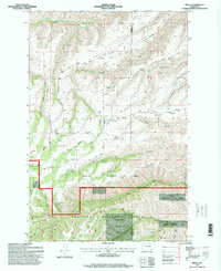
 1995 Rose Springs1998 Print · USGSThe high ridges of Garfield County are captured here in the mid-1990s, showing a landscape defined by forest management and wildlife areas. Genealogists and historians can trace the paths of Bosley Grade and find named water sources like Rose Springs and Lanzie Spring.
 - 1995 Map of Troy, 1998 Print
 1995 Troy1998 Print · USGSThe remote border of Oregon and Washington is captured here in the mid-1990s at the meeting of the Grande Ronde River and Wenaha River. Researchers can trace old family roots at Bartlett Cemetery or locate specialized river infrastructure like the Fish Ladder.
 - 1995 Map of Saddle Butte, 1998 Print
 1995 Saddle Butte1998 Print · USGSAsotin and Garfield counties are seen here in the mid-1990s, revealing a landscape of remote ridges and vital water sources within the Umatilla National Forest. Genealogists and historians can locate legacy sites like the H A McEachan Ranch and the Wenatchee Guard Station.
End of results
Showing maps 1-9 of 9
Top cities of Garfield County
Frequently asked questions
- What are the different types of historical maps available for Garfield County?
- What is the oldest map of Garfield County?
- Where can I purchase historical maps of Garfield County for my home or office?
- Where can I download high-res historical maps of Garfield County?
- Are there historical topographic maps available for Garfield County?
- Is there historical aerial imagery available for Garfield County?
- Where are historical maps of Garfield County sourced from?