1960s Maps of Pomeroy, Washington
Explore 2 historic maps of Pomeroy from the 1960s. These maps offer a rare glimpse into what life looked like during the 1960s — showing old roads, neighborhoods, homes, and landmarks that have changed or disappeared over time.
Whether you're researching your family's past, planning a metal detecting trip, or studying how Pomeroy's landscape evolved across the 1960s, these high-resolution maps are a powerful tool for exploring the history of this region.
- Focus on a specific era: All maps on this page are from the 1960s, giving you a focused view of this time period.
- See what’s changed: Compare century-old streets, trails, and buildings to today's modern landscape using overlays and satellite layers.
- Research with precision: Use these maps for genealogy, historical research, land use analysis, or educational projects.
- View, download, or print: Maps are fully viewable online in high resolution, and can be downloaded or printed for your own records.
Start exploring Pomeroy's history through authentic maps from the 1960s. This is your window into the past.
Pomeroy, WA maps
(2)- 1967 Map of Pomeroy, 1971 Print
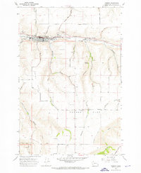 1967 Pomeroy1971 Print · USGSPomeroy and the surrounding Garfield County plateaus are captured here in the late sixties. Genealogists and local historians can trace family plots at Holy Rosary Cemetery or locate the old Holy Rosary Sch and the County Fairgrounds.
 - 1967 Map of Zumwalt, 1971 Print
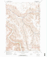 1967 Zumwalt1971 Print · USGSThe rural valleys of Garfield and Columbia Counties are captured here during the late sixties, highlighting the deep gulches and river bottoms. Family historians and researchers can trace the Union Pacific line, locate the Owsley Cem, and find local landmarks like the Grange Hall and Marengo.2 unique versions available
End of results
Showing maps 1-2 of 2
Frequently asked questions
- What are the different types of historical maps available for Pomeroy?
- What is the oldest map of Pomeroy?
- Where can I purchase historical maps of Pomeroy for my home or office?
- Where can I download high-res historical maps of Pomeroy?
- Are there historical topographic maps available for Pomeroy?
- Is there historical aerial imagery available for Pomeroy?
- Where are historical maps of Pomeroy sourced from?