1960s Maps of Wanapum Village, Washington
Explore 2 historic maps of Wanapum Village from the 1960s. These maps offer a rare glimpse into what life looked like during the 1960s — showing old roads, neighborhoods, homes, and landmarks that have changed or disappeared over time.
Whether you're researching your family's past, planning a metal detecting trip, or studying how Wanapum Village's landscape evolved across the 1960s, these high-resolution maps are a powerful tool for exploring the history of this region.
- Focus on a specific era: All maps on this page are from the 1960s, giving you a focused view of this time period.
- See what’s changed: Compare century-old streets, trails, and buildings to today's modern landscape using overlays and satellite layers.
- Research with precision: Use these maps for genealogy, historical research, land use analysis, or educational projects.
- View, download, or print: Maps are fully viewable online in high resolution, and can be downloaded or printed for your own records.
Start exploring Wanapum Village's history through authentic maps from the 1960s. This is your window into the past.
Wanapum Village, WA maps
(2)- 1965 Map of Beverly, 1966 Print
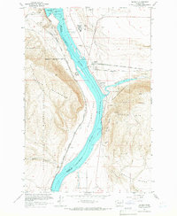 1965 Beverly1966 Print · USGSThe mid-Columbia River valley comes alive in this mid-sixties survey of the Sentinel Gap and Saddle Mountains. Researchers can trace the railroad operations at Beverly Junction and the infrastructure of the newly built Wanapum Dam.
 - 1965 Map of Beverly, 1966 Print
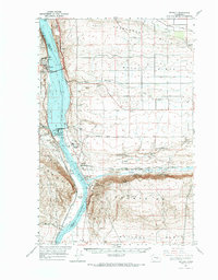 1965 Beverly1966 Print · USGSCentral Washington during the mid-sixties reveals a river landscape transformed by hydroelectric power and irrigation. You can trace the rail corridor of the Chicago Milwaukee St Paul and Pacific and locate settlements like Wanapum Village and Vantage.
End of results
Showing maps 1-2 of 2
Top cities near Wanapum Village
Frequently asked questions
- What are the different types of historical maps available for Wanapum Village?
- What is the oldest map of Wanapum Village?
- Where can I purchase historical maps of Wanapum Village for my home or office?
- Where can I download high-res historical maps of Wanapum Village?
- Are there historical topographic maps available for Wanapum Village?
- Is there historical aerial imagery available for Wanapum Village?
- Where are historical maps of Wanapum Village sourced from?