1940s Maps of Dilworth, Washington
Explore 1 historic maps of Dilworth from the 1940s. These maps offer a rare glimpse into what life looked like during the 1940s — showing old roads, neighborhoods, homes, and landmarks that have changed or disappeared over time.
Whether you're researching your family's past, planning a metal detecting trip, or studying how Dilworth's landscape evolved across the 1940s, these high-resolution maps are a powerful tool for exploring the history of this region.
- Focus on a specific era: All maps on this page are from the 1940s, giving you a focused view of this time period.
- See what’s changed: Compare century-old streets, trails, and buildings to today's modern landscape using overlays and satellite layers.
- Research with precision: Use these maps for genealogy, historical research, land use analysis, or educational projects.
- View, download, or print: Maps are fully viewable online in high resolution, and can be downloaded or printed for your own records.
Start exploring Dilworth's history through authentic maps from the 1940s. This is your window into the past.
Dilworth, WA maps
(1)- 1949 Map of Vashon, 1956 Print
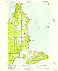 1949 Vashon1956 Print · USGSVashon and Maury Islands are captured here in the late 1940s, showing a landscape defined by waterfront settlements and maritime life. Genealogists can trace family locations in small communities like Burton, Ellisport, and Sylvan Beach, or find local landmarks such as Vashon Sch and the KOMO Radio Towers.4 unique versions available
End of results
Showing maps 1-1 of 1
Top cities near Dilworth
- Seattle historical maps
- Tacoma historical maps
- Bellevue historical maps
- Kent historical maps
- Renton historical maps
- Federal Way historical maps
See more
Frequently asked questions
- What are the different types of historical maps available for Dilworth?
- What is the oldest map of Dilworth?
- Where can I purchase historical maps of Dilworth for my home or office?
- Where can I download high-res historical maps of Dilworth?
- Are there historical topographic maps available for Dilworth?
- Is there historical aerial imagery available for Dilworth?
- Where are historical maps of Dilworth sourced from?