Old Maps of Ernies Grove, Washington
Explore 7 old maps of Ernies Grove, spanning from 1921 to today. These high-resolution historic maps reveal how streets, neighborhoods, landmarks, and natural features evolved over time — perfect for genealogy, metal detecting, research, and local history exploration.
What you can do with these maps:
- See how Ernies Grove changed over time: Compare historical maps to modern-day views to trace roads, homesites, rail lines & more.
- View detailed metadata: Each map includes creators, publishers, year, scale, and archive source.
- Overlay maps with satellite & LiDAR: Visualize the past alongside modern tools to explore terrain & human change.
- Trusted historical sources: Maps sourced from the USGS, Library of Congress, and other archives.
- Access maps your way: View online, download high-res files, or order prints for personal or research use.
Start exploring old maps of Ernies Grove to uncover forgotten places, hidden landmarks, and the deep history beneath your feet.
Ernies Grove, WA maps
(7)- 1921 Map of Sultan
 1921 Sultan1921 Print · USGSThe Snoqualmie and Skykomish river valleys are defined by timber and rail in the 1920s. Researchers can trace early industry through the Apex Mines, Coke Ovens, and rural schools like Mountain View School.4 unique versions available
 - 1923 Map of Sultan
 1923 Sultan1923 Print · USGSThe Skykomish and Snoqualmie river valleys thrive in the early twenties as centers of timber and rail. Genealogists can trace family roots through rural sites like Forest Glade School or follow the Lumber RR lines to the Apex Mines.4 unique versions available
 - 1957 Map of Wenatchee, 1973 Print
 1957 Wenatchee1973 Print · USGSThe northern Cascades and Columbia River valley appear here in the mid-fifties, showing the region's critical rail and transit corridors. Researchers can trace the routes of the Great Northern RR and Milwaukee Road through settlements like Skykomish, Baring, and Dryden.2 unique versions available
 - 1960 Map of Mount Si, 1962 Print
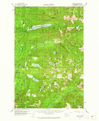 1960 Mount Si1962 Print · USGSThe King County highlands are shown here in the early sixties as a critical water and mineral resource area. Genealogists and researchers can locate Ernies Grove and trace old mining sites like the Lennox Mines or the Apex Mine.3 unique versions available
 - 1975 Map of Skykomish River, 1977 Print
 1975 Skykomish River1977 Print · USGSThe Cascades meet the river valleys in the mid-seventies, showing the vital rail corridors and mountain towns along the Skykomish River. Researchers can trace the path of the Pacific Crest National Scenic Trail and locate historic sites like State Reformatory Farm No 2 and the Old Cascade Tunnel.2 unique versions available
 - 1989 Map of Mount Si
 1989 Mount Si1989 Print · USGSThe foothills of the Cascades near King County are documented here in the late eighties as timber and recreation interests shaped the land. Researchers can trace forest access via 4WD tracks to high-country landmarks like Lake Hancock, Mount Si, and Ernies Grove.
 - 2023 Map of Mount Si, 2023 Print
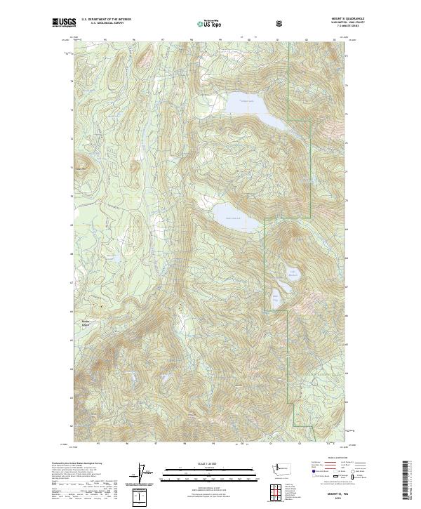 2023 Mount Si2023 Print · USGSThe foothills of the Cascades are documented here in the early twenty-first century, showing the interface of wilderness and forestry management. Researchers can trace the rugged access roads to Ernies Grove or locate remote alpine basins like Lake Hancock and Lake Moolock.
End of results
Showing maps 1-7 of 7
Top cities near Ernies Grove
- Sammamish historical maps
- Snoqualmie historical maps
- Duvall historical maps
- North Bend historical maps
- Carnation historical maps
- Riverbend historical maps
See more
Frequently asked questions
- What are the different types of historical maps available for Ernies Grove?
- What is the oldest map of Ernies Grove?
- Where can I purchase historical maps of Ernies Grove for my home or office?
- Where can I download high-res historical maps of Ernies Grove?
- Are there historical topographic maps available for Ernies Grove?
- Is there historical aerial imagery available for Ernies Grove?
- Where are historical maps of Ernies Grove sourced from?