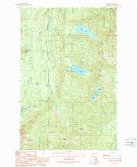
1989 Map of Mount Si
USGS Topo · Published 1989About this map
Ernies Grove sits at the edge of a landscape defined by significant elevation changes and high-altitude water bodies in the late 1980s. The North Fork Snoqualmie River carves through the center of the sheet, dividing the terrain between prominent peaks like Fuller Mountain and Mount Si. To the east, the Snoqualmie National Forest encompasses a series of alpine lakes, including Calligan Lake, Lake Hancock, and Lake Moolock.
Find a feature on this map
29 named features on this map. Tap any name to fly to it.
Don’t see what you’re looking for? This feature index may not catch every label — zoom into the map to look around manually.
Map Details
Editions of this 1989 Mount Si Map
This is the sole edition of this map. No revisions or reprints were ever made.
Other maps of this area

1913 · Cedar Lake
USGS Topo · 1:125,000

1921 · Sultan
USGS Topo · 1:125,000

1923 · Sultan
USGS Topo · 1:125,000

1953 · Snoqualmie
USGS Topo · 1:24,000

1953 · North Bend
USGS Topo · 1:24,000

1953 · Lake Joy
USGS Topo · 1:24,000

1957 · Wenatchee
USGS Topo · 1:250,000

1960 · Mount Si
USGS Topo · 1:62,500

1960 · Bandera
USGS Topo · 1:62,500

1975 · Snoqualmie Pass
USGS Topo · 1:100,000