1950s Maps of Greenwater, Washington
Explore 2 historic maps of Greenwater from the 1950s. These maps offer a rare glimpse into what life looked like during the 1950s — showing old roads, neighborhoods, homes, and landmarks that have changed or disappeared over time.
Whether you're researching your family's past, planning a metal detecting trip, or studying how Greenwater's landscape evolved across the 1950s, these high-resolution maps are a powerful tool for exploring the history of this region.
- Focus on a specific era: All maps on this page are from the 1950s, giving you a focused view of this time period.
- See what’s changed: Compare century-old streets, trails, and buildings to today's modern landscape using overlays and satellite layers.
- Research with precision: Use these maps for genealogy, historical research, land use analysis, or educational projects.
- View, download, or print: Maps are fully viewable online in high resolution, and can be downloaded or printed for your own records.
Start exploring Greenwater's history through authentic maps from the 1950s. This is your window into the past.
Greenwater, WA maps
(2)- 1956 Map of Greenwater, 1958 Print
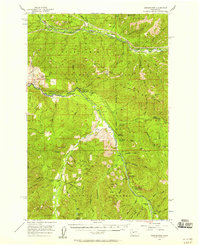 1956 Greenwater1958 Print · USGSThe Green River and White River valleys in the mid-1950s reveal a landscape of timber-rail settlements and mountain camps. Genealogists and historians can trace the Northern Pacific line through Nagrom or locate sites like Hot Springs and the Camp Sheppard Boy Scout Camp.4 unique versions available
 - 1957 Map of Wenatchee, 1973 Print
 1957 Wenatchee1973 Print · USGSThe northern Cascades and Columbia River valley appear here in the mid-fifties, showing the region's critical rail and transit corridors. Researchers can trace the routes of the Great Northern RR and Milwaukee Road through settlements like Skykomish, Baring, and Dryden.2 unique versions available
End of results
Showing maps 1-2 of 2
Frequently asked questions
- What are the different types of historical maps available for Greenwater?
- What is the oldest map of Greenwater?
- Where can I purchase historical maps of Greenwater for my home or office?
- Where can I download high-res historical maps of Greenwater?
- Are there historical topographic maps available for Greenwater?
- Is there historical aerial imagery available for Greenwater?
- Where are historical maps of Greenwater sourced from?