1900s (20th Century) Maps of Scenic, Washington
Explore 5 historic maps of Scenic from the 1900s (20th Century). These maps offer a rare glimpse into what life looked like during the 1900s — showing old roads, neighborhoods, homes, and landmarks that have changed or disappeared over time.
Whether you're researching your family's past, planning a metal detecting trip, or studying how Scenic's landscape evolved across the 1900s, these high-resolution maps are a powerful tool for exploring the history of this region.
- Focus on a specific era: All maps on this page are from the 1900s, giving you a focused view of this time period.
- See what’s changed: Compare century-old streets, trails, and buildings to today's modern landscape using overlays and satellite layers.
- Research with precision: Use these maps for genealogy, historical research, land use analysis, or educational projects.
- View, download, or print: Maps are fully viewable online in high resolution, and can be downloaded or printed for your own records.
Start exploring Scenic's history through authentic maps from the 1900s. This is your window into the past.
Scenic, WA maps
(5)- 1902 Map of Skykomish
 1902 Skykomish1902 Print · USGSThe central Cascades were defined by the rail corridor at the turn of the century as the high passes were first conquered. Genealogists and historians can trace early mountain settlements like Monte Cristo, Mineral City, and Skykomish along the Great Northern Railway.
 - 1905 Map of Skykomish
 1905 Skykomish1905 Print · USGSThe central Cascades at the start of the century reveal a landscape of high-altitude mining and the engineering of the Great Northern railroad. Trace early mountain settlements like Monte Cristo, the rail siding at Tonga, and the original Cascade Tunnel.7 unique versions available
 - 1957 Map of Wenatchee, 1973 Print
 1957 Wenatchee1973 Print · USGSThe northern Cascades and Columbia River valley appear here in the mid-fifties, showing the region's critical rail and transit corridors. Researchers can trace the routes of the Great Northern RR and Milwaukee Road through settlements like Skykomish, Baring, and Dryden.2 unique versions available
 - 1965 Map of Scenic, 1967 Print
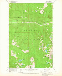 1965 Scenic1967 Print · USGSIn the mid-1960s, the high Cascades near the King and Chelan county line remained a rugged corridor of rail engineering and wilderness trails. Genealogists and hikers can trace the original Great Northern Railroad alignment, the Cascade Tunnel, and the historic Tonga Ridge Pack Trail.4 unique versions available
 - 1975 Map of Skykomish River, 1977 Print
 1975 Skykomish River1977 Print · USGSThe Cascades meet the river valleys in the mid-seventies, showing the vital rail corridors and mountain towns along the Skykomish River. Researchers can trace the path of the Pacific Crest National Scenic Trail and locate historic sites like State Reformatory Farm No 2 and the Old Cascade Tunnel.2 unique versions available
End of results
Showing maps 1-5 of 5
Top cities near Scenic
Frequently asked questions
- What are the different types of historical maps available for Scenic?
- What is the oldest map of Scenic?
- Where can I purchase historical maps of Scenic for my home or office?
- Where can I download high-res historical maps of Scenic?
- Are there historical topographic maps available for Scenic?
- Is there historical aerial imagery available for Scenic?
- Where are historical maps of Scenic sourced from?