1980s Maps of Seattle, Washington
Explore 5 historic maps of Seattle from the 1980s. These maps offer a rare glimpse into what life looked like during the 1980s — showing old roads, neighborhoods, homes, and landmarks that have changed or disappeared over time.
Whether you're researching your family's past, planning a metal detecting trip, or studying how Seattle's landscape evolved across the 1980s, these high-resolution maps are a powerful tool for exploring the history of this region.
- Focus on a specific era: All maps on this page are from the 1980s, giving you a focused view of this time period.
- See what’s changed: Compare century-old streets, trails, and buildings to today's modern landscape using overlays and satellite layers.
- Research with precision: Use these maps for genealogy, historical research, land use analysis, or educational projects.
- View, download, or print: Maps are fully viewable online in high resolution, and can be downloaded or printed for your own records.
Start exploring Seattle's history through authentic maps from the 1980s. This is your window into the past.
Seattle, WA maps
(5)- 1983 Map of Seattle South
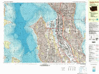 1983 Seattle South1983 Print · USGSSeattle in the early eighties shows a dense urban landscape defined by its bustling harbor and growing infrastructure. Researchers can trace the development of Rainier Valley, the industrial footprint of Harbor Island, and the sites of landmarks like the Kingdome and Seattle Center.3 unique versions available
 - 1983 Map of Bellevue South
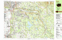
 1983 Bellevue South1983 Print · USGSThe Eastside area between Lake Washington and Lake Sammamish was rapidly developing into a major suburban hub in the early eighties. Researchers can trace neighborhood growth through Beaux Arts Village, locate family records at Sunset Hills Mem Park (Cem), or follow the old Burlington Northern line.
 - 1983 Map of Renton
 1983 Renton1983 Print · USGSRenton and the Cedar River valley are shown here in the early eighties as suburban growth began to surround the massive Lake Youngs Watershed. Researchers can trace local landmarks like Greenwood Cem, the Burlington Northern railroad, and established neighborhoods from Bryn Mawr to Maple Valley.
 - 1983 Map of Seattle North
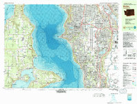
 1983 Seattle North1983 Print · USGSNorth Seattle and its surrounding waters are captured here in the early eighties, showcasing the city's dense residential expansion and maritime heritage. Genealogists and historians can trace neighborhood developments from Ballard to Wedgwood or locate local institutions like Acacia Mem Park (Cem) and the University of Washington.2 unique versions available
 - 1983 Map of Burien
 1983 Burien1983 Print · USGSPuget Sound and the expanding Sea-Tac corridor define the landscape of King County in the early eighties. Genealogists and researchers can trace local landmarks from Vashon Island Airport to the Washington Memorial Park Cemetery and Burien General Hospital.
End of results
Showing maps 1-5 of 5
Top cities near Seattle
- Bellevue historical maps
- Kent historical maps
- Renton historical maps
- Kirkland historical maps
- Redmond historical maps
- Shoreline historical maps
See more
Top neighborhoods of Seattle
- Chinatown International District historical maps
- Capitol Hill historical maps
- Harrison/Denny–Blaine historical maps
- Leschi historical maps
- Beacon Hill historical maps
- Belltown historical maps
See more
Frequently asked questions
- What are the different types of historical maps available for Seattle?
- What is the oldest map of Seattle?
- Where can I purchase historical maps of Seattle for my home or office?
- Where can I download high-res historical maps of Seattle?
- Are there historical topographic maps available for Seattle?
- Is there historical aerial imagery available for Seattle?
- Where are historical maps of Seattle sourced from?