1950s Maps of Poulsbo, Washington
Explore 5 historic maps of Poulsbo from the 1950s. These maps offer a rare glimpse into what life looked like during the 1950s — showing old roads, neighborhoods, homes, and landmarks that have changed or disappeared over time.
Whether you're researching your family's past, planning a metal detecting trip, or studying how Poulsbo's landscape evolved across the 1950s, these high-resolution maps are a powerful tool for exploring the history of this region.
- Focus on a specific era: All maps on this page are from the 1950s, giving you a focused view of this time period.
- See what’s changed: Compare century-old streets, trails, and buildings to today's modern landscape using overlays and satellite layers.
- Research with precision: Use these maps for genealogy, historical research, land use analysis, or educational projects.
- View, download, or print: Maps are fully viewable online in high resolution, and can be downloaded or printed for your own records.
Start exploring Poulsbo's history through authentic maps from the 1950s. This is your window into the past.
Poulsbo, WA maps
(5)- 1953 Map of Poulsbo, 1954 Print
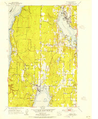 1953 Poulsbo1954 Print · USGSKitsap County's shoreline and military landscape are frozen in time during the mid-fifties as naval operations and small-town life intersect. Genealogists and historians can trace family locations near Poulsbo Cemetery, the rail stop at Silverdale Siding, and schools like Pearson Sch.4 unique versions available
 - 1953 Map of Port Gamble, 1955 Print
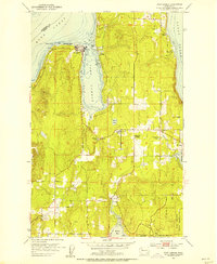 1953 Port Gamble1955 Print · USGSThe northern Kitsap Peninsula in the early fifties shows a region defined by its timber economy and coastal settlements. Researchers can trace the layout of Port Gamble and its sawmill, find family sites at the Wolfe School, or locate land within the Port Madison Indian Reservation.5 unique versions available
 - 1953 Map of Lofall, 1955 Print
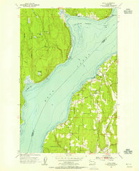 1953 Lofall1955 Print · USGSThe Hood Canal shoreline during the mid-fifties shows a landscape of ferry crossings and small coastal settlements. Researchers can trace the legacy of the Lofall Ferry, locate the Vinland Church, and find early sites like Breidablick and Standard Sch.5 unique versions available
 - 1953 Map of Suquamish, 1955 Print
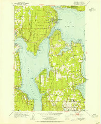 1953 Suquamish1955 Print · USGSBainbridge Island and the Kitsap Peninsula show their mid-century maritime character, as seen in the naval facilities and waterfront settlements along the sound. Trace family history through local landmarks like Indianola, the Commodore Bainbridge Sch, and the Madison Ch.5 unique versions available
 - 1958 Map of Seattle, 1966 Print
 1958 Seattle1966 Print · USGSThe Puget Sound region in the mid-fifties showcases a balance of urban growth and Olympic wilderness. Trace the industrial waterfronts of Tacoma, old naval facilities like Keyport Naval Res, and mountain peaks like Mount Constance.3 unique versions available
End of results
Showing maps 1-5 of 5
Top cities near Poulsbo
- Seattle historical maps
- Edmonds historical maps
- Bremerton historical maps
- Bainbridge Island historical maps
- Silverdale historical maps
- Port Orchard historical maps
See more
Top neighborhoods of Poulsbo
Frequently asked questions
- What are the different types of historical maps available for Poulsbo?
- What is the oldest map of Poulsbo?
- Where can I purchase historical maps of Poulsbo for my home or office?
- Where can I download high-res historical maps of Poulsbo?
- Are there historical topographic maps available for Poulsbo?
- Is there historical aerial imagery available for Poulsbo?
- Where are historical maps of Poulsbo sourced from?