1940s Maps of Wilbur, Washington
Explore 2 historic maps of Wilbur from the 1940s. These maps offer a rare glimpse into what life looked like during the 1940s — showing old roads, neighborhoods, homes, and landmarks that have changed or disappeared over time.
Whether you're researching your family's past, planning a metal detecting trip, or studying how Wilbur's landscape evolved across the 1940s, these high-resolution maps are a powerful tool for exploring the history of this region.
- Focus on a specific era: All maps on this page are from the 1940s, giving you a focused view of this time period.
- See what’s changed: Compare century-old streets, trails, and buildings to today's modern landscape using overlays and satellite layers.
- Research with precision: Use these maps for genealogy, historical research, land use analysis, or educational projects.
- View, download, or print: Maps are fully viewable online in high resolution, and can be downloaded or printed for your own records.
Start exploring Wilbur's history through authentic maps from the 1940s. This is your window into the past.
Wilbur, WA maps
(2)- 1948 Map of Grand Coulee Dam, 1955 Print
 1948 Grand Coulee Dam1955 Print · USGSThe Grand Coulee region underwent a massive transformation by the late 1940s as the dam transformed the river valley into a sprawling reservoir. Trace the growth of Coulee Dam and Grand Coulee, and locate rural landmarks like the Grand Coulee Grange and Bagdad Junction.6 unique versions available
 - 1948 Map of Wilbur, 1964 Print
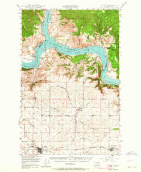 1948 Wilbur1964 Print · USGSLincoln County is captured here in the years following the creation of the Grand Coulee reservoir. Genealogists and historians can trace the rail-side growth of Wilbur and Creston or locate rural landmarks like the Potlatch Grange and Sherman.2 unique versions available
End of results
Showing maps 1-2 of 2
Top cities near Wilbur
Frequently asked questions
- What are the different types of historical maps available for Wilbur?
- What is the oldest map of Wilbur?
- Where can I purchase historical maps of Wilbur for my home or office?
- Where can I download high-res historical maps of Wilbur?
- Are there historical topographic maps available for Wilbur?
- Is there historical aerial imagery available for Wilbur?
- Where are historical maps of Wilbur sourced from?