1980s Maps of Wilbur, Washington
Explore 3 historic maps of Wilbur from the 1980s. These maps offer a rare glimpse into what life looked like during the 1980s — showing old roads, neighborhoods, homes, and landmarks that have changed or disappeared over time.
Whether you're researching your family's past, planning a metal detecting trip, or studying how Wilbur's landscape evolved across the 1980s, these high-resolution maps are a powerful tool for exploring the history of this region.
- Focus on a specific era: All maps on this page are from the 1980s, giving you a focused view of this time period.
- See what’s changed: Compare century-old streets, trails, and buildings to today's modern landscape using overlays and satellite layers.
- Research with precision: Use these maps for genealogy, historical research, land use analysis, or educational projects.
- View, download, or print: Maps are fully viewable online in high resolution, and can be downloaded or printed for your own records.
Start exploring Wilbur's history through authentic maps from the 1980s. This is your window into the past.
Wilbur, WA maps
(3)- 1983 Map of Coulee Dam
 1983 Coulee Dam1983 Print · USGSThe high plateau and deep coulees of central Washington are captured here in the early eighties, centered on the massive Franklin D Roosevelt Lake and the towns of Coulee Dam and Grand Coulee. Researchers can trace the Burlington Northern rail corridor through old stops at Govan and Mondovi or locate the historic Fort Spokane.2 unique versions available
 - 1989 Map of Wilbur
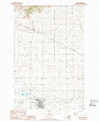 1989 Wilbur1989 Print · USGSThe town of Wilbur and its surrounding Lincoln County ranch lands are documented here in the late eighties. Genealogists and local historians can locate the community Cem, trace the path of Goose Creek, and identify landmarks like the Wilbur Airport.
 - 1989 Map of Broadax Draw
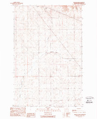 1989 Broadax Draw1989 Print · USGSThe high plateau of Lincoln County is documented here in the late eighties as a land of utility corridors and small outposts. Researchers can locate remote features like Hesseltine, Broadax Spring, and the private Landing Strip near Corbett.
End of results
Showing maps 1-3 of 3
Top cities near Wilbur
Frequently asked questions
- What are the different types of historical maps available for Wilbur?
- What is the oldest map of Wilbur?
- Where can I purchase historical maps of Wilbur for my home or office?
- Where can I download high-res historical maps of Wilbur?
- Are there historical topographic maps available for Wilbur?
- Is there historical aerial imagery available for Wilbur?
- Where are historical maps of Wilbur sourced from?