1950s Maps of Mason County, Washington
Explore 17 historic maps of Mason County from the 1950s. These maps offer a rare glimpse into what life looked like during the 1950s — showing old roads, neighborhoods, homes, and landmarks that have changed or disappeared over time.
Whether you're researching your family's past, planning a metal detecting trip, or studying how Mason County's landscape evolved across the 1950s, these high-resolution maps are a powerful tool for exploring the history of this region.
- Focus on a specific era: All maps on this page are from the 1950s, giving you a focused view of this time period.
- See what’s changed: Compare century-old streets, trails, and buildings to today's modern landscape using overlays and satellite layers.
- Research with precision: Use these maps for genealogy, historical research, land use analysis, or educational projects.
- View, download, or print: Maps are fully viewable online in high resolution, and can be downloaded or printed for your own records.
Start exploring Mason County's history through authentic maps from the 1950s. This is your window into the past.
Mason County, WA maps
(17)- 1950 Map of The Brothers
 1950 The Brothers1950 Print · USGSThe Jefferson County coast meets the Olympic peaks in the mid-century, capturing the area's transition from the Hood Canal shoreline to high wilderness. Researchers can trace early backcountry camps and coastal landmarks like John Ahl Sch, Camp Collins, and the Hamma Hamma Guard Sta.2 unique versions available
 - 1950 Map of Mt Christie
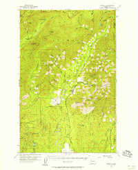
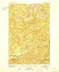 1950 Mt Christie1950 Print · USGSJefferson and Grays Harbor counties appear here during the mid-century, showing a landscape of backcountry shelters and mountain trails. You can trace the routes of early hikers and rangers through Graves Creek Inn, the Muncaster Sch, and Chicago Camp.2 unique versions available
 - 1950 Map of Mt. Steel
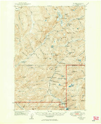 1950 Mt. Steel1950 Print · USGSThe interior Olympic Peninsula at mid-century reveals a high-country wilderness of glaciers and remote outposts. Trace the locations of backcountry sites like Chalet, Hammer Cabin, and the Darky Mine along the North Fork Skokomish River.2 unique versions available
 - 1952 Map of Potlatch, 1954 Print
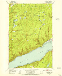
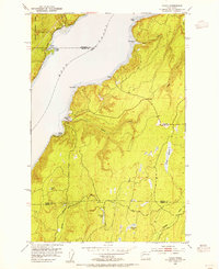
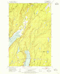
 1952 Potlatch1954 Print · USGSHood Canal and the Skokomish River delta were centers of maritime and timber life in the early fifties. Genealogists and researchers can trace local landmarks like the Skokomish Indian Reservation, the Tahuya School, and the community of Hoodsport as they appeared before modern expansion.3 unique versions available
 - 1953 Map of Vaughn, 1954 Print
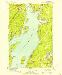 1953 Vaughn1954 Print · USGSCoastal life in the early fifties unfolds along Case Inlet, where remote settlements and island homesteads defined the South Sound. Genealogists and historians can trace the foundations of Grapeview, Home, and Vaughn alongside landmarks like Stretch Island and the Lakebay School.4 unique versions available
 - 1953 Map of Lake Wooten, 1955 Print
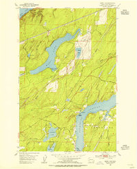
 1953 Lake Wooten1955 Print · USGSThe Kitsap Peninsula shoreline meets the deep waters of Hood Canal in the mid-1950s, a period of growing recreation and forestry. Trace the early development of Belfair State Park and coastal settlements like Sunbeach and Shady Beach.5 unique versions available
 - 1953 Map of Holly, 1955 Print
 1953 Holly1955 Print · USGSThe Kitsap Peninsula in the early fifties is shown here as a quiet landscape of timber and tide. Researchers can trace remote settlements like Holly and Hintzville or locate family landmarks near Morgan Marsh and the Tahuya River.6 unique versions available
 - 1953 Map of Wildcat Lake, 1955 Print
 1953 Wildcat Lake1955 Print · USGSKitsap and Mason counties meet in this mid-century survey of the peninsula's forested interior and glacial lakes. Genealogists and local historians can trace small communities like Camp Union and Hite Center or locate the Barney White Ranch and McKenna Falls.4 unique versions available
 - 1953 Map of Mason Lake, 1955 Print
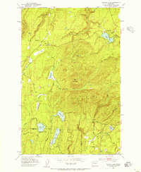
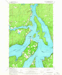
 1953 Mason Lake1955 Print · USGSCoastal Mason County was a landscape of transit and timber in the mid-fifties, shaped by the waters of the Hood Canal and Pickering Passage. You can trace early settlements at Hartstene and Little Hoquiam, find the Cem near Jarrell Cove, and locate the Northern Pacific railroad corridor.5 unique versions available
 - 1953 Map of Belfair, 1955 Print
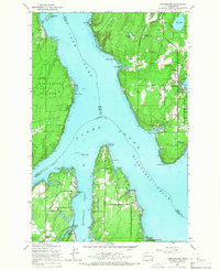
 1953 Belfair1955 Print · USGSThe head of Hood Canal and the North Bay waterfront are captured here in the early fifties, showing the rural development of Mason and Kitsap Counties. Genealogists and local historians can trace the foundations of Belfair, Allyn, and Victor, alongside landmarks like the Belfair Sch and the Northern Pacific rail line.4 unique versions available
 - 1953 Map of Mt Tebo, 1955 Print
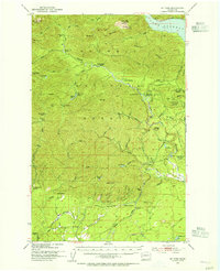 1953 Mt Tebo1955 Print · USGSThe Mason and Grays Harbor county line was a hub of timber production and wilderness management in the 1950s. Genealogists and historians can trace old logging infrastructure like Fir Creek Reload, primitive campsites at Camp 3 (Site), and the remote Le Bar Guard Sta.3 unique versions available
 - 1953 Map of Shelton, 1956 Print
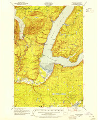
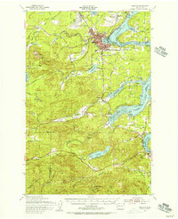 1953 Shelton1956 Print · USGSThe Mason County waterfront and its timbered interior come alive in this mid-century survey of the inlets surrounding Shelton. Trace the legacy of rural education and military history at Bordeaux Sch, New Kamilche, and the Naval Auxiliary Air Station.2 unique versions available
 - 1953 Map of Elma, 1956 Print
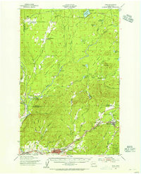 1953 Elma1956 Print · USGSGrays Harbor and Mason Counties come alive in the early fifties, showing a region defined by its timber economy and river valleys. Genealogists and historians can trace rail-side settlements like Deckerville, Rayville, and Elma, or locate family sites near Turnow Cem and the Mary M Knight School.2 unique versions available
 - 1955 Map of Grisdale, 1957 Print
 1955 Grisdale1957 Print · USGSGrays Harbor and Mason counties are shown during the height of mid-century timber operations, centered on the logging community of Grisdale. Researchers can trace the extensive timber rail network, including the Schaefer Railroad and Anderson Logging RR, alongside landmarks like Satsop Guard Sta.4 unique versions available
 - 1958 Map of Seattle, 1966 Print
 1958 Seattle1966 Print · USGSThe Puget Sound region in the mid-fifties showcases a balance of urban growth and Olympic wilderness. Trace the industrial waterfronts of Tacoma, old naval facilities like Keyport Naval Res, and mountain peaks like Mount Constance.3 unique versions available
 - 1959 Map of Squaxin Island, 1966 Print
 1959 Squaxin Island1966 Print · USGSThe southern reaches of Puget Sound come alive in the late fifties, showing the intricate island and inlet geography of Mason and Thurston counties. Researchers can trace local landmarks like the Boston Harbor Sch, the Squaxin Island Indian Reservation, and the Marine RR at Arcadia.4 unique versions available
 - 1959 Map of Longbranch, 1966 Print
 1959 Longbranch1966 Print · USGSThe South Puget Sound shoreline comes alive in the late fifties, showcasing the maritime communities of Longbranch and Ballow before modern development. Genealogists and historians can trace local landmarks like Evergreen Sch, the Lighthouse at Johnson Point, and the docks of Filucy Bay.3 unique versions available
End of results
Showing maps 1-17 of 17
Top cities of Mason County
Frequently asked questions
- What are the different types of historical maps available for Mason County?
- What is the oldest map of Mason County?
- Where can I purchase historical maps of Mason County for my home or office?
- Where can I download high-res historical maps of Mason County?
- Are there historical topographic maps available for Mason County?
- Is there historical aerial imagery available for Mason County?
- Where are historical maps of Mason County sourced from?