1980s Maps of Mason County, Washington
Explore 15 historic maps of Mason County from the 1980s. These maps offer a rare glimpse into what life looked like during the 1980s — showing old roads, neighborhoods, homes, and landmarks that have changed or disappeared over time.
Whether you're researching your family's past, planning a metal detecting trip, or studying how Mason County's landscape evolved across the 1980s, these high-resolution maps are a powerful tool for exploring the history of this region.
- Focus on a specific era: All maps on this page are from the 1980s, giving you a focused view of this time period.
- See what’s changed: Compare century-old streets, trails, and buildings to today's modern landscape using overlays and satellite layers.
- Research with precision: Use these maps for genealogy, historical research, land use analysis, or educational projects.
- View, download, or print: Maps are fully viewable online in high resolution, and can be downloaded or printed for your own records.
Start exploring Mason County's history through authentic maps from the 1980s. This is your window into the past.
Mason County, WA maps
(15)- 1981 Map of Mc Cleary
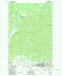
 1981 Mc Cleary1981 Print · USGSThe Grays Harbor and Mason County line comes alive in the early eighties, showing the timber-country settlements of McCleary and Garden City along the rail line. Researchers can trace the Burlington Northern tracks and locate sites like the Mark E Reed Memorial Hospital and Monkeys Prairie.
 - 1981 Map of Elma
 1981 Elma1981 Print · USGSGrays Harbor County at the start of the eighties shows a landscape shaped by the Satsop River and the Burlington Northern line. Researchers can pinpoint property near Hunters Prairie, trace the Old RR Grade, or locate family sites by the Cem in Elma.
 - 1981 Map of Nahwatzel Lake
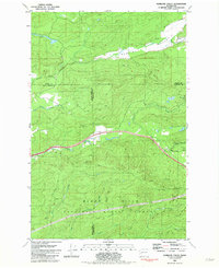
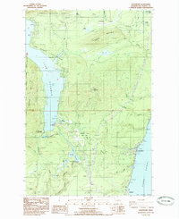
 1981 Nahwatzel Lake1981 Print · USGSMason County timberlands and prairies are captured here in the early eighties as industrial rail lines still traced the woods. You can locate the Logging Railroad path, the grounds of Camp Bishop, and named openings like Goose Prairie.
 - 1981 Map of Matlock, 1982 Print
 1981 Matlock1982 Print · USGSMason County’s logging and river landscape comes to life in the early 1980s, centered on the Matlock area. Researchers can trace the timber rail network from Frisken Wye to the Matlock Siding or locate sites like the Tornow Cemetery.
 - 1981 Map of Kamilche Valley, 1982 Print
 1981 Kamilche Valley1982 Print · USGSThe timberlands and valleys of Thurston and Mason counties are captured here in the early eighties. Genealogists and historians can trace the Burlington Northern rail line and locate landmarks like the Boy Scout Camp at Summit Lake and the Marmac settlement.
 - 1981 Map of Shelton, 1982 Print
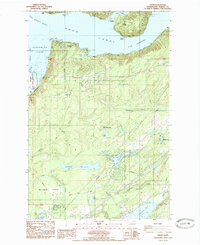
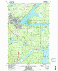 1981 Shelton1982 Print · USGSThe Puget Sound shoreline near Shelton is documented here in the early eighties, showing the region's dense network of inlets and timber-driven infrastructure. Researchers can trace the Burlington Northern rail lines or locate landmarks like Shelton Mem Park (Cem) and the Drive-in Theater.2 unique versions available
 - 1981 Map of Summit Lake, 1982 Print
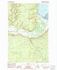
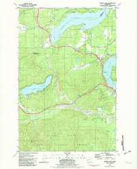 1981 Summit Lake1982 Print · USGSThe inlets and uplands west of Olympia come alive in this early eighties survey of the Mason and Thurston county line. Genealogists and local historians can trace the rural landscape from the Griffin Sch to the shores of Summit Lake and Totten Inlet.2 unique versions available
 - 1985 Map of Hoodsport
 1985 Hoodsport1985 Print · USGSThe Mason County shoreline and Olympic foothills are captured here in the mid-eighties, showing the industrial and recreational footprint of the Skokomish River. Researchers can trace the hydroelectric infrastructure of Cushman Dam or locate local landmarks like Hoodsport and the Deer Meadow Gaging Station.
 - 1985 Map of Eldon
 1985 Eldon1985 Print · USGSThe western shores of Hood Canal come into focus in the mid-1980s, where the Olympic foothills meet the saltwater. Researchers can trace coastal landmarks like Eldon and Ayock Point or locate the interior Hamma Hamma F S Station and its surrounding camps.
 - 1985 Map of Mt Washington
 1985 Mt Washington1985 Print · USGSThe high peaks of the Olympic range appear here in the mid-1980s, marking the rugged boundary of Mason and Jefferson counties. Trace the paths around Mt Washington, the waters of Lena Lake, and old resource sites like the Gravel Pit near the Hamma Hamma River.2 unique versions available
 - 1985 Map of Lilliwaup
 1985 Lilliwaup1985 Print · USGSMason County's shoreline along the Hood Canal is captured here in the mid-1980s, showcasing the maritime settlements of the Olympic Peninsula. Genealogists and hikers can trace the coastal landmarks of Lilliwaup and Dewatto, or locate interior features like Maggie Lake and The Peat Bog.
 - 1985 Map of Union
 1985 Union1985 Print · USGSMason County’s shoreline where the Hood Canal turns sharply is captured here in the mid-eighties, showing the transition from tidal flats to timbered uplands. Genealogists and local historians can trace the development of Union, Tahuya, and Trolley Park, or locate family-named features like Mc Ewen Prairie and Keene Lake.
 - 1986 Map of Skokomish Valley
 1986 Skokomish Valley1986 Print · USGSThe Skokomish Valley and Hood Canal shoreline are captured here in the mid-eighties as the local salmon-rearing and tribal infrastructure expanded. Researchers can locate the Skokomish Cem, the Wash State Patrol Academy, and the George Adams Salmon Hatchery.2 unique versions available
 - 1988 Map of Shelton
 1988 Shelton1988 Print · USGSThe Olympic Peninsula's transition from high mountain wilderness to Puget Sound tideflats is captured here in the late eighties. Researchers can trace the path of the Logging Railroad or locate historical sites like Sanderson Field and the Skokomish Indian Reservation.
 - 1988 Map of Mount Olympus
 1988 Mount Olympus1988 Print · USGSThe Olympic Peninsula's glacial heart is captured here in the late eighties, documenting the reach of permanent ice and river headwaters. Trace the contours of the Bailey Range and identify landmarks like Sol Duc Hot Springs and the Seven Lakes Basin.
End of results
Showing maps 1-15 of 15
Top cities of Mason County
Frequently asked questions
- What are the different types of historical maps available for Mason County?
- What is the oldest map of Mason County?
- Where can I purchase historical maps of Mason County for my home or office?
- Where can I download high-res historical maps of Mason County?
- Are there historical topographic maps available for Mason County?
- Is there historical aerial imagery available for Mason County?
- Where are historical maps of Mason County sourced from?