1990s Maps of Mason County, Washington
Explore 21 historic maps of Mason County from the 1990s. These maps offer a rare glimpse into what life looked like during the 1990s — showing old roads, neighborhoods, homes, and landmarks that have changed or disappeared over time.
Whether you're researching your family's past, planning a metal detecting trip, or studying how Mason County's landscape evolved across the 1990s, these high-resolution maps are a powerful tool for exploring the history of this region.
- Focus on a specific era: All maps on this page are from the 1990s, giving you a focused view of this time period.
- See what’s changed: Compare century-old streets, trails, and buildings to today's modern landscape using overlays and satellite layers.
- Research with precision: Use these maps for genealogy, historical research, land use analysis, or educational projects.
- View, download, or print: Maps are fully viewable online in high resolution, and can be downloaded or printed for your own records.
Start exploring Mason County's history through authentic maps from the 1990s. This is your window into the past.
Mason County, WA maps
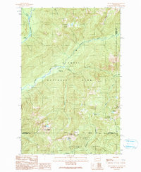
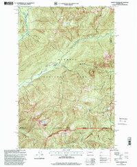
(21)- 1990 Map of Lightning Peak
 1990 Lightning Peak1990 Print · USGSThe Olympic Peninsula highlands come into focus in the 1990s as the protected Mount Skokomish Wilderness meets the river valleys. Researchers can trace the South Fork Skokomish River and locate Brown Creek Campground and Lightning Peak.
 - 1990 Map of Grisdale
 1990 Grisdale1990 Print · USGSThe timberlands of the Olympic Peninsula are captured here in the 1990s as the logging community of Grisdale transitions. Genealogists and local historians can trace the drainages of the West Fork Satsop River and find landmarks like the Satsop FS Station and Weatherwax Ridge.
 - 1990 Map of Mount Tebo
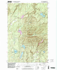
 1990 Mount Tebo1990 Print · USGSThe Olympic Peninsula backcountry comes into sharp focus during the late twentieth century, showing the remote drainages of the Skokomish River. Researchers can locate high-elevation landmarks like Mount Tebo, Spider Lake, and the protected Wonder Mountain Wilderness.
 - 1990 Map of Mount Skokomish
 1990 Mount Skokomish1990 Print · USGSThe high peaks and alpine basins of the Olympic Peninsula come to life in this late-century survey. Researchers can trace remote history at the Darky Mine and locate established backcountry sites like Camp Pleasant or the Staircase Campground.
 - 1990 Map of Wynoochee Lake
 1990 Wynoochee Lake1990 Print · USGSGrays Harbor County at the close of the twentieth century shows the rugged timberlands and waterways of the Olympic Peninsula. Hikers and researchers can trace the East Fork Humptulips River Trail and locate recreation sites like Coho Campground Boat Ramp and Wynoochee Falls Campground.
 - 1990 Map of Dry Bed Lakes
 1990 Dry Bed Lakes1990 Print · USGSThe Mason and Grays Harbor county line in the early nineties shows a timber-rich landscape within the Olympic National Forest. You can trace the complex Satsop watershed through Dry Bed Lakes, Vance Creek, and several remote forest work sites like the Gravel Pit.
 - 1990 Map of Mount Olson
 1990 Mount Olson1990 Print · USGSThe Olympic Peninsula backcountry is shown here in the 1990s, where federal lands converge at the headwaters of the Quinault River. Trace high-altitude landmarks like Mount Olson, the remote Big Log Camp, and the waters of Lake Success.
 - 1990 Map of Mount Hoquiam
 1990 Mount Hoquiam1990 Print · USGSThe Olympic wilderness comes into focus in the 1990s at the high-country junction of Jefferson, Mason, and Grays Harbor counties. Researchers can trace remote trails and landmarks like Mount Hoquiam, Graves Creek Ranger Station, and the high waters of Lake Sundown.
 - 1990 Map of Vance Creek
 1990 Vance Creek1990 Print · USGSMason County’s logging interior is captured here in the late twentieth century, showing the forest management and timber settlements of the Olympic Peninsula. Researchers can trace the layout of Grisdale, the Fir Creek FS Station, and remote camps like Camp Govey.
 - 1990 Map of Vaughn, 2003 Print
 1990 Vaughn2003 Print · USGSThe Key Peninsula and Case Inlet appear in the 1990s as a quiet network of coastal settlements and maritime harbors. Researchers can trace the layout of waterfront communities like Grapeview and Lakebay or locate local landmarks including the Vaughn Community Church and Key Peninsula Sch.
 - 1991 Map of Tacoma
 1991 Tacoma1991 Print · USGSThe South Sound and Tacoma waterfront appear here in the early nineties, showing a landscape defined by deep-water inlets and massive federal installations. Researchers can trace the development of Lakewood Center or locate the historic rail lines of the Burlington Northern Railroad and Union Pacific Railroad.
 - 1992 Map of Seattle, 1993 Print
 1992 Seattle1993 Print · USGSThe Seattle metropolitan area and Puget Sound are shown here in the early nineties during a period of rapid suburban and technological growth. Researchers can trace the development of Mercer Island, locate the Bangor Naval Submarine Base, and study the industrial layout of Boeing Field.2 unique versions available
 - 1995 Map of Wynoochee Lake, 1997 Print
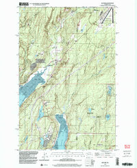
 1995 Wynoochee Lake1997 Print · USGSThe Olympic Peninsula wilderness in the mid-1990s is defined here by the creation of Wynoochee Lake and its surrounding timberlands. Local researchers can trace forest access via the Quinault Hood Canal Rd and locate sites like Hunter Camp, Chetwoot, and Coho.
 - 1997 Map of Wildcat Lake, 2003 Print
 1997 Wildcat Lake2003 Print · USGSThe Kitsap Peninsula highlands appear in the late twentieth century as a landscape of mountain ridges and secluded lake communities. Researchers can trace the development of Camp Union, the sprawling Union River Reservoir, and family landmarks like the Barney White Ranch.
 - 1997 Map of Squaxin Island, 2003 Print
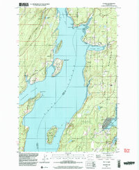
 1997 Squaxin Island2003 Print · USGSThe southern Puget Sound reaches of Mason and Thurston counties appear here in the late nineties, showing a landscape defined by deep inlets and island life. Researchers can locate the Squaxin Island Indian Reservation, the Boston Harbor Sch, and waterfront settlements like Arcadia and Carlyon Beach.
 - 1997 Map of Mason Lake, 2003 Print
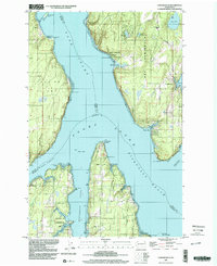
 1997 Mason Lake2003 Print · USGSCoastal Mason County and its interior lakes come into focus in the late nineties, showcasing the geography between the Hood Canal and Harstine Island. Genealogists and locals can locate the Grapeview Sch, a Cem, and small landings like Walkers Landing and Little Hoquiam.
 - 1997 Map of Longbranch, 2003 Print
 1997 Longbranch2003 Print · USGSThe South Puget Sound landscape in the late nineties showcases a complex network of inlets and peninsulas before recent coastal developments. Researchers can trace historic shorelines and landmarks from Longbranch and Ballow to the Woodard Bay Conservation Area and Devils Head.
 - 1999 Map of Mount Hoquiam, 2001 Print
 1999 Mount Hoquiam2001 Print · USGSHigh in the Olympic Peninsula at the end of the twentieth century, this survey tracks the wild terrain where the National Park and Forest meet. Researchers can trace remote routes like the Primitive Trail and locate sites such as the Graves Creek Ranger Station and Wolf Bar Camp.
 - 1999 Map of Mount Olson, 2001 Print
 1999 Mount Olson2001 Print · USGSThe high Olympic wilderness comes into sharp focus during the late 1990s as the Forest Service revised this complex watershed divide. Researchers can trace the alpine Primitive Trail past Lake Success and across the steep slopes of Six Ridge.
 - 1999 Map of Lake Wooten, 2003 Print
 1999 Lake Wooten2003 Print · USGSThe Kitsap Peninsula shoreline and its inland lake country are captured here at the close of the twentieth century. Genealogists and local historians can locate Dewatto Cem, the Tahuya Lookout, and waterfront communities like Sunbeach and Forest Beach.
 - 1999 Map of Belfair, 2003 Print
 1999 Belfair2003 Print · USGSThe Mason County shoreline near the turn of the millennium shows a landscape shaped by the Hood Canal and North Bay. Researchers can trace local infrastructure from the Navy Railroad to the Sand Hill Sch and the Lake Koeneman Wildlife Area.
End of results
Showing maps 1-21 of 21
Top cities of Mason County
Frequently asked questions
- What are the different types of historical maps available for Mason County?
- What is the oldest map of Mason County?
- Where can I purchase historical maps of Mason County for my home or office?
- Where can I download high-res historical maps of Mason County?
- Are there historical topographic maps available for Mason County?
- Is there historical aerial imagery available for Mason County?
- Where are historical maps of Mason County sourced from?