1900s (20th Century) Maps of Oroville, Washington
Explore 8 historic maps of Oroville from the 1900s (20th Century). These maps offer a rare glimpse into what life looked like during the 1900s — showing old roads, neighborhoods, homes, and landmarks that have changed or disappeared over time.
Whether you're researching your family's past, planning a metal detecting trip, or studying how Oroville's landscape evolved across the 1900s, these high-resolution maps are a powerful tool for exploring the history of this region.
- Focus on a specific era: All maps on this page are from the 1900s, giving you a focused view of this time period.
- See what’s changed: Compare century-old streets, trails, and buildings to today's modern landscape using overlays and satellite layers.
- Research with precision: Use these maps for genealogy, historical research, land use analysis, or educational projects.
- View, download, or print: Maps are fully viewable online in high resolution, and can be downloaded or printed for your own records.
Start exploring Oroville's history through authentic maps from the 1900s. This is your window into the past.
Oroville, WA maps
(8)- 1902 Map of Osoyoos
 1902 Osoyoos1902 Print · USGSOkanogan County at the dawn of the twentieth century was a landscape of high-country mines and riverfront settlements along the Canadian border. Genealogists and historians can trace early mining operations at Okanogan Free Gold Mine or locate early towns like Molson, Chesaw, and Oroville.
 - 1904 Map of Osoyoos
 1904 Osoyoos1904 Print · USGSOkanogan County near the Canadian border is shown here during a period of mining expansion and early ranching. You can trace the proximity of the Okanogan Free Gold Mine to Oroville or locate early settlements like Molson, Chesaw, and Huntley Ranch.3 unique versions available
 - 1954 Map of Okanogan, 1964 Print
 1954 Okanogan1964 Print · USGSNorth Central Washington’s interior comes into focus during the mid-fifties, showing the rise of the Columbia River reservoir system. Genealogists and historians can trace the Great Northern rail line and locate historical mining operations at the Mountain Lion Mine or Gold Hill Mine.2 unique versions available
 - 1957 Map of Oroville, 1959 Print
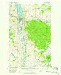 1957 Oroville1959 Print · USGSThe Okanogan Valley at the close of the 1950s shows a frontier landscape defined by the convergence of the Similkameen and Okanogan rivers. Local historians can trace the Great Northern Railway route past the Lucky Knock Mine and through early settlements like Oroville and Ellisforde.3 unique versions available
 - 1958 Map of Okanogan
 1958 Okanogan1958 Print · USGSThe Okanogan River valley and the Colville Indian Reservation are shown here in the late fifties, during a period of established river and rail commerce. Researchers can trace the Great Northern line through Oroville or locate landmarks like the Knowlton School and Orient Ranger Station.
 - 1975 Map of Oroville NW, 1977 Print
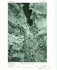 1975 Oroville NW1977 Print · USGSOroville and the Canadian borderlands are captured in the mid-1970s, revealing the junction of river valleys and high-latitude agriculture. Researchers can trace the winding course of the Okanogan River and the shoreline of Osoyoos Lake.
 - 1982 Map of Oroville
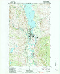 1982 Oroville1982 Print · USGSOroville sits at the gateway to the Okanogan Valley in the early 1980s, where the Similkameen and Okanogan rivers meet just south of the Canadian border. Researchers can trace the local infrastructure of the era, from the Dorothy Scott Airport and Burlington Northern line to the Riverview Cem.2 unique versions available
 - 1984 Map of Oroville
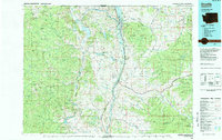 1984 Oroville1984 Print · USGSThe Okanogan highlands at the Canadian border reveal a landscape of deep river valleys and historic mining claims in the early 1980s. Genealogists and researchers can trace old settlements like Nighthawk and Loomis or locate the American Girl Mine.
End of results
Showing maps 1-8 of 8
Top cities near Oroville
Frequently asked questions
- What are the different types of historical maps available for Oroville?
- What is the oldest map of Oroville?
- Where can I purchase historical maps of Oroville for my home or office?
- Where can I download high-res historical maps of Oroville?
- Are there historical topographic maps available for Oroville?
- Is there historical aerial imagery available for Oroville?
- Where are historical maps of Oroville sourced from?