1990s Maps of Pacific County, Washington
Explore 3 historic maps of Pacific County from the 1990s. These maps offer a rare glimpse into what life looked like during the 1990s — showing old roads, neighborhoods, homes, and landmarks that have changed or disappeared over time.
Whether you're researching your family's past, planning a metal detecting trip, or studying how Pacific County's landscape evolved across the 1990s, these high-resolution maps are a powerful tool for exploring the history of this region.
- Focus on a specific era: All maps on this page are from the 1990s, giving you a focused view of this time period.
- See what’s changed: Compare century-old streets, trails, and buildings to today's modern landscape using overlays and satellite layers.
- Research with precision: Use these maps for genealogy, historical research, land use analysis, or educational projects.
- View, download, or print: Maps are fully viewable online in high resolution, and can be downloaded or printed for your own records.
Start exploring Pacific County's history through authentic maps from the 1990s. This is your window into the past.
Pacific County, WA maps
(3)- 1992 Map of Chehalis River, 1993 Print
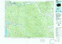 1992 Chehalis River1993 Print · USGSThe Chehalis River valley and the timberlands of the Black Hills are captured here in the early nineties. Researchers can trace rail-and-river history through Montesano and Raymond, or locate the unique Mima Mounds and Bordeaux.2 unique versions available
 - 1994 Map of East of Raymond
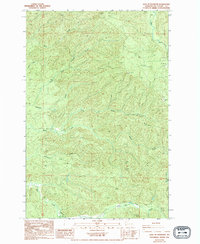 1994 East of Raymond1994 Print · USGSPacific County’s timber-rich interior is shown in the mid-nineties, documenting a landscape shaped by drainage and transport. Genealogists and historians can trace the path of The Railroad Grade or locate specific points along Fall River and Fairchild Creek.
 - 1996 Map of Warrenton, 1999 Print
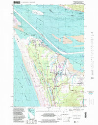 1996 Warrenton1999 Print · USGSThe Clatsop Plains and the mouth of the Columbia River are shown here in the mid-nineties, a landscape shaped by military history and maritime industry. Researchers can trace the layout of Hammond, find the Ocean View Cem, and locate the Fort Clatsop National Memorial.
End of results
Showing maps 1-3 of 3
Top cities of Pacific County
- Raymond historical maps
- South Bend historical maps
- Ocean Park historical maps
- Long Beach historical maps
- Ilwaco historical maps
- Tokeland historical maps
Frequently asked questions
- What are the different types of historical maps available for Pacific County?
- What is the oldest map of Pacific County?
- Where can I purchase historical maps of Pacific County for my home or office?
- Where can I download high-res historical maps of Pacific County?
- Are there historical topographic maps available for Pacific County?
- Is there historical aerial imagery available for Pacific County?
- Where are historical maps of Pacific County sourced from?