1980s Maps of Pacific County, Washington
Explore 19 historic maps of Pacific County from the 1980s. These maps offer a rare glimpse into what life looked like during the 1980s — showing old roads, neighborhoods, homes, and landmarks that have changed or disappeared over time.
Whether you're researching your family's past, planning a metal detecting trip, or studying how Pacific County's landscape evolved across the 1980s, these high-resolution maps are a powerful tool for exploring the history of this region.
- Focus on a specific era: All maps on this page are from the 1980s, giving you a focused view of this time period.
- See what’s changed: Compare century-old streets, trails, and buildings to today's modern landscape using overlays and satellite layers.
- Research with precision: Use these maps for genealogy, historical research, land use analysis, or educational projects.
- View, download, or print: Maps are fully viewable online in high resolution, and can be downloaded or printed for your own records.
Start exploring Pacific County's history through authentic maps from the 1980s. This is your window into the past.
Pacific County, WA maps
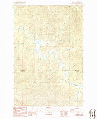
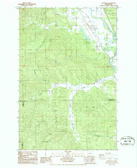
(19)- 1980 Map of Ilwaco, 1989 Print
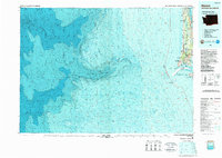 1980 Ilwaco1989 Print · USGSThe Washington-Oregon borderlands come into focus during the 1980s, revealing the coastal communities of the North Beach Peninsula and the mouth of the Columbia. Researchers can trace historical sites like Fort Canby State Park, locate the North Head Lighthouse, and explore the shoreline from Ocean Park to Ilwaco.
 - 1981 Map of Astoria, 1982 Print
 1981 Astoria1982 Print · USGSThe Oregon and Washington borderlands meet at the Columbia River estuary in the early eighties, a time of active timber transport and maritime trade. Researchers can trace the river's many islands, the grounds of Fort Stevens, and riverside towns like Cathlamet and Westport.3 unique versions available
 - 1984 Map of Chinook, 1985 Print
 1984 Chinook1985 Print · USGSThe Washington coast met the Columbia River in the mid-1980s as a land of tide-influenced marshes and family-run ranches. Researchers can trace land holdings at Kyle Ranch and Beeker Ranch or locate the shoreline lights at Sand Island.
 - 1986 Map of Doty
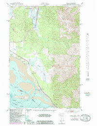
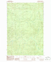
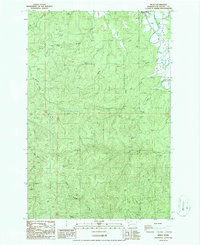
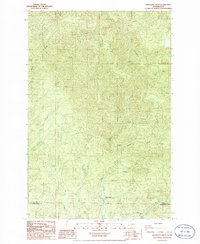
 1986 Doty1986 Print · USGSThe Chehalis River valley in the mid-1980s reveals a timber and rail landscape defined by the Doty Hills. Researchers can trace the heritage of small settlements like Doty and Dryad, locate the Sylvan Cem, or follow the Old R. R. Grade through the river bottomlands.2 unique versions available
 - 1986 Map of Brooklyn
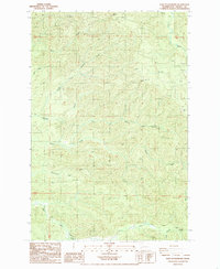
 1986 Brooklyn1986 Print · USGSThe timber lands of the Grays Harbor and Pacific County border are captured here in the mid-1980s. Local researchers can trace old river-bottom sites like Brooklyn and Vesta, or locate the isolated Cem and Footbridge along the winding North River.2 unique versions available
 - 1986 Map of Raymond
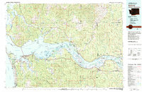
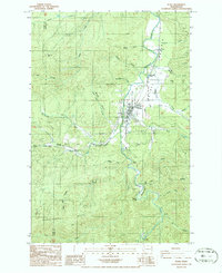
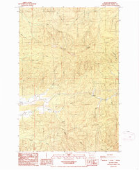
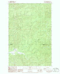
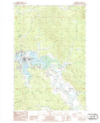 1986 Raymond1986 Print · USGSThe Willapa River basin in the mid-1980s reveals a transition from the industrial and residential hubs of Raymond to the surrounding timber and river lands. Researchers can trace the layout of riverside settlements like Willapa and Menlo, or locate landmarks such as the Historical Marker and local Cem sites.2 unique versions available
 - 1986 Map of Pe Ell
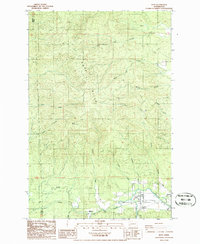
 1986 Pe Ell1986 Print · USGSThe Lewis County timberlands and the Chehalis River valley are captured here in the mid-1980s. Local historians can trace the townsite of Pe Ell, the settlement at Walville, and named landmarks like Fisk Falls and Pe Ell Prairie.2 unique versions available
 - 1986 Map of Elochoman Pass
 1986 Elochoman Pass1986 Print · USGSThe high timberlands of the Washington interior are captured here in the mid-1980s at the meeting of three counties. Researchers can trace the headwaters of the Chehalis River and find localized landmarks like Elochoman Pass and the Borrow Pit.
 - 1986 Map of Cedarville
 1986 Cedarville1986 Print · USGSThe Chehalis River valley in the mid-1980s shows a landscape of timber management and river-bottom settlements. Researchers can trace the development of Cedarville and Independence or locate rural infrastructure like the Landing Strip and Old Road Grade.2 unique versions available
 - 1986 Map of Dean Creek
 1986 Dean Creek1986 Print · USGSPacific and Washington counties are shown in the mid-1980s as a landscape of timber-driven infrastructure and intricate waterways. Researchers can trace the path of the Old Railroad Grade and locate features like Suem Creek, Elk Creek, and various high-elevation Borrow Pit sites.2 unique versions available
 - 1986 Map of Pluvius
 1986 Pluvius1986 Print · USGSPacific County timberlands and river valleys are frozen in time during the mid-1980s. Local historians can trace the development of Frances and Prairie or locate natural landmarks like Willapa Falls and the summits of Walville Peak and Pluvius Hill.2 unique versions available
 - 1986 Map of Blaney Creek
 1986 Blaney Creek1986 Print · USGSPacific and Wahkiakum Counties are shown in the mid-1980s as a landscape of timber ridges and salmon-bearing waters. Local researchers can trace the course of the Grays River Salmon Pond or locate historic resource sites like the Quarry and Barrow Pit.
 - 1986 Map of Menlo
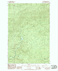
 1986 Menlo1986 Print · USGSPacific County at the mid-eighties reveals a landscape defined by the winding Willapa River and the rural community of Menlo. Genealogists and local historians can trace the intricate network of watercourses including Trap Creek and the Naselle River among numerous hillside quarries.
 - 1986 Map of Blue Mountain
 1986 Blue Mountain1986 Print · USGSGrays Harbor and Pacific counties meet in this mid-1980s survey of the timbered hills around the North River. Researchers can trace remote creek systems like Raimie Creek and Redfield Creek, or locate the isolated Cem near the riverbank.2 unique versions available
 - 1986 Map of Lebam
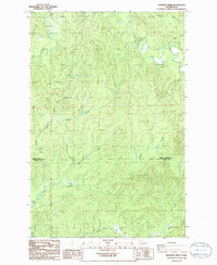
 1986 Lebam1986 Print · USGSPacific County's river valley settlements are captured in the mid-1980s as they follow the winding Willapa River. Researchers can trace the legacy of timber and rail through landmarks like the Old Railroad Grade and small communities such as Lebam and Frances.2 unique versions available
 - 1986 Map of Elkhorn Creek
 1986 Elkhorn Creek1986 Print · USGSThe remote timberlands of the Willapa Hills are captured in the mid-1980s, documenting the border between Grays Harbor and Pacific counties. Researchers can trace the winding course of the North River and its many tributaries, including Star Hill and the West Fork Elkhorn Creek.2 unique versions available
 - 1986 Map of Sweigiler Creek
 1986 Sweigiler Creek1986 Print · USGSThe Pacific and Wahkiakum county line in the 1980s reveals a landscape of deep timbered valleys and critical river systems. Genealogists and researchers can trace the waters of the Naselle River or locate the site of the Grays River State Fish Hatchery.
 - 1986 Map of East of Raymond
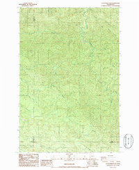
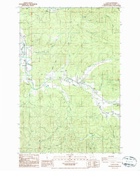
 1986 East of Raymond1986 Print · USGSPacific County timberlands are captured in the 1980s, revealing a landscape carved by industry and numerous waterways. Researchers can trace the path of the old Railroad Grade or locate early resource sites like the various Borrow Pit labels and the Fall River.
 - 1989 Map of Westport
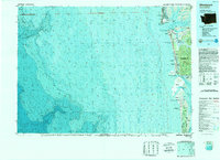 1989 Westport1989 Print · USGSThe Washington coast and the mouth of Grays Harbor are captured in the late eighties, documenting the maritime infrastructure and coastal settlements of the era. Researchers can trace the development of Westport, Ocean Shores, and historic waterfronts like Oysterville or Bay City.
End of results
Showing maps 1-19 of 19
Top cities of Pacific County
- Raymond historical maps
- South Bend historical maps
- Ocean Park historical maps
- Long Beach historical maps
- Ilwaco historical maps
- Tokeland historical maps
Frequently asked questions
- What are the different types of historical maps available for Pacific County?
- What is the oldest map of Pacific County?
- Where can I purchase historical maps of Pacific County for my home or office?
- Where can I download high-res historical maps of Pacific County?
- Are there historical topographic maps available for Pacific County?
- Is there historical aerial imagery available for Pacific County?
- Where are historical maps of Pacific County sourced from?