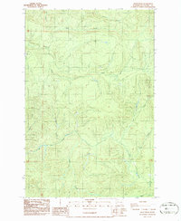
1986 Map of Dean Creek
USGS Topo · Published 1986About this map
The timbered hills of Pacific and Washington counties are defined by a complex network of drainages and industrial paths as they appeared in the early 1980s. The landscape is carved by numerous watercourses, including Dean Creek, Suem Creek, and Elk Creek, which feed into larger systems. An Old Railroad Grade and Old Road Grade traverse the central portion of the map, tracing the legacy of the region's logging and transport infrastructure. Several Borrow Pit locations are marked near the ridges, indicating ongoing maintenance or construction projects during this era. This provisional survey captures the transition between the high ridges and the valleys of Martin Creek and Fourth Creek, documenting the terrain before later reforestation or development altered these historical transport corridors.
Find a feature on this map
19 named features on this map. Tap any name to fly to it.
Don’t see what you’re looking for? This feature index may not catch every label — zoom into the map to look around manually.
Map Details
Editions of this 1986 Dean Creek Map
2 editions found
Other maps of this area

1940 · Montesano
USGS Topo · 1:62,500

1941 · Walville
USGS Topo · 1:62,500

1941 · Ford
USGS Topo · 1:62,500

1953 · Hoquiam
USGS Topo · 1:250,000

1953 · Pe Ell
USGS Topo · 1:62,500

1953 · Malone
USGS Topo · 1:62,500

1955 · Montesano
USGS Topo · 1:62,500

1955 · Raymond
USGS Topo · 1:62,500

1957 · Hoquiam
USGS Topo · 1:250,000

1958 · Hoquiam
USGS Topo · 1:250,000