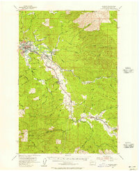
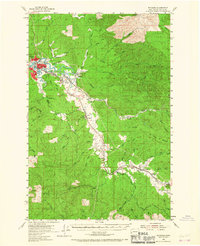
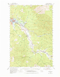
1955 Map of Raymond
USGS Topo · Published 1957About this map
The Willapa River system dominates this mid-century landscape, winding through a network of small settlements and logging-related outposts. Near the confluence of the South Fork Willapa River and the main stem, the town of Raymond serves as the regional hub, supported by a density of infrastructure including the Washington Cem and several local campuses like Riverview Sch and Sylvandale School. Moving inland along the Northern Pacific line, the geography transitions into the forested heights of P and E Ridge, where the timber economy is evident through features like Camp One.
Find a feature on this map
58 named features on this map. Tap any name to fly to it.
Don’t see what you’re looking for? This feature index may not catch every label — zoom into the map to look around manually.
Map Details
Editions of this 1955 Raymond Map
Other maps of this area

1938 · Fort Columbia
USGS Topo · 1:62,500

1938 · South Bend
USGS Topo · 1:62,500
1940 · Montesano
USGS Topo · 1:62,500

1940 · Brookfield
USGS Topo · 1:62,500

1940 · South Bend
USGS Topo · 1:62,500

1941 · Walville
USGS Topo · 1:62,500

1941 · Skamokawa
USGS Topo · 1:62,500

1941 · Ford
USGS Topo · 1:62,500

1943 · Fort Columbia
USGS Topo · 1:62,500

1949 · Upper Naselle River
USGS Topo · 1:24,000