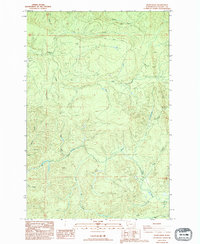
1986 Map of Dean Creek
USGS Topo · Published 1994About this map
Dean Creek and its complex network of tributaries define this timber-rich landscape in southwestern Washington as it appeared in the mid-1980s. The topography is etched with the legacy of industrial logging, most notably an Old Railroad Grade and an Old Road Grade that snake through the drainage basins of Smith Creek and Little Elk Creek. These infrastructure markers provide insight into the historical accessibility and extraction methods used in this Pacific County terrain before modern revisions took hold.
Find a feature on this map
19 named features on this map. Tap any name to fly to it.
Don’t see what you’re looking for? This feature index may not catch every label — zoom into the map to look around manually.
Map Details
Editions of this 1986 Dean Creek Map
2 editions found
Other maps of this area

1940 · Montesano
USGS Topo · 1:62,500

1941 · Walville
USGS Topo · 1:62,500

1941 · Ford
USGS Topo · 1:62,500

1953 · Hoquiam
USGS Topo · 1:250,000

1953 · Pe Ell
USGS Topo · 1:62,500

1953 · Malone
USGS Topo · 1:62,500

1955 · Montesano
USGS Topo · 1:62,500

1955 · Raymond
USGS Topo · 1:62,500

1957 · Hoquiam
USGS Topo · 1:250,000

1958 · Hoquiam
USGS Topo · 1:250,000