1950s Maps of San Juan County, Washington
Explore 10 historic maps of San Juan County from the 1950s. These maps offer a rare glimpse into what life looked like during the 1950s — showing old roads, neighborhoods, homes, and landmarks that have changed or disappeared over time.
Whether you're researching your family's past, planning a metal detecting trip, or studying how San Juan County's landscape evolved across the 1950s, these high-resolution maps are a powerful tool for exploring the history of this region.
- Focus on a specific era: All maps on this page are from the 1950s, giving you a focused view of this time period.
- See what’s changed: Compare century-old streets, trails, and buildings to today's modern landscape using overlays and satellite layers.
- Research with precision: Use these maps for genealogy, historical research, land use analysis, or educational projects.
- View, download, or print: Maps are fully viewable online in high resolution, and can be downloaded or printed for your own records.
Start exploring San Juan County's history through authentic maps from the 1950s. This is your window into the past.
San Juan County, WA maps
(10)- 1951 Map of Deception Pass, 1953 Print
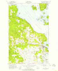
 1951 Deception Pass1953 Print · USGSWhidbey and Fidalgo Islands appear here in the early fifties as the region's naval and agricultural identities merged. Genealogists and local historians can trace early schools and coastal landmarks like Rosario School, Fort Whitman, and the village of La Conner.3 unique versions available
 - 1951 Map of Anacortes, 1953 Print
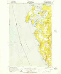
 1951 Anacortes1953 Print · USGSThe northern Puget Sound islands and the city of Anacortes are captured here in the early fifties during a period of steady coastal growth. Researchers can locate vanished landmarks and family roots at Eden Cem, Sinclair Sch, and the Lummi Indian Reservation.2 unique versions available
 - 1953 Map of Stuart Island, 1957 Print
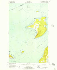
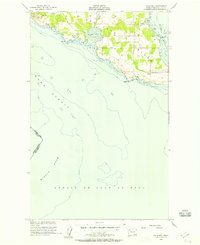
 1953 Stuart Island1957 Print · USGSThe San Juan Islands archipelago appears here in the early fifties, caught between the international boundary and the deep channels of the Haro Strait. Researchers can trace early infrastructure like the Lighthouse at Turn Point, the small settlement of Prevost, and island cemeteries.2 unique versions available
 - 1954 Map of Roche Harbor, 1957 Print
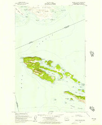
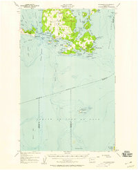
 1954 Roche Harbor1957 Print · USGSSan Juan Island and Henry Island are captured in the 1950s, documenting the maritime life and historic sites of the Pacific Northwest. Trace the boundaries of the English Campsite (1859), locate local Quarries, and find the Lime Kiln Lighthouse.4 unique versions available
 - 1954 Map of Waldron Island, 1957 Print
 1954 Waldron Island1957 Print · USGSThe San Juan Islands remained a quiet maritime frontier in the mid-fifties, dominated by rocky shorelines and international waters. Trace the layout of the Waldron settlement, locate the island Cemetery, or find the Abandoned Quarry on the nearby cliffs of Orcas Island.4 unique versions available
 - 1954 Map of Friday Harbor, 1957 Print
 1954 Friday Harbor1957 Print · USGSSan Juan Island in the mid-fifties shows a landscape of coastal settlements and maritime research centers. Genealogists and historians can locate the St Francis Xavier Mission, the Cem, and the scientific outposts at the Oceanographic Laboratories.4 unique versions available
 - 1954 Map of False Bay, 1957 Print
 1954 False Bay1957 Print · USGSSan Juan Island's southern coast is documented here in the mid-fifties, showing the intersection of major straits and the island's rural road network. Historians can locate the American Campsite and Pickett's Monument near Eagle Cove.3 unique versions available
 - 1957 Map of Richardson, 1958 Print
 1957 Richardson1958 Print · USGSLopez Island and the surrounding San Juan archipelago are shown in the late fifties as a landscape of quiet maritime life and isolated beacons. Genealogists and historians can locate the Lopez Sch, trace the roads around Telegraph Hill, and find the Smith Island National Wildlife Refuge.2 unique versions available
 - 1957 Map of Orcas Island, 1959 Print
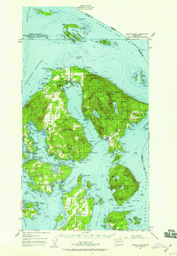 1957 Orcas Island1959 Print · USGSThe San Juan Islands are shown here in the late fifties, a time when coastal settlements and island retreats defined the archipelago. Genealogists and historians can trace old community centers like Griswold, Doe Bay, and the early layout of Moran State Park.2 unique versions available
 - 1957 Map of Victoria, 1960 Print
 1957 Victoria1960 Print · USGSThe San Juan Islands and the North Cascades coastline are shown in detail during the late fifties, a period of significant military and industrial presence. Researchers can trace historic rail lines like the Great Northern or locate sites such as the Whidbey Island Naval Air Sta and Friday Harbor.4 unique versions available
End of results
Showing maps 1-10 of 10
Top cities of San Juan County
Frequently asked questions
- What are the different types of historical maps available for San Juan County?
- What is the oldest map of San Juan County?
- Where can I purchase historical maps of San Juan County for my home or office?
- Where can I download high-res historical maps of San Juan County?
- Are there historical topographic maps available for San Juan County?
- Is there historical aerial imagery available for San Juan County?
- Where are historical maps of San Juan County sourced from?