Old Maps of San Juan County, Washington for Metal Detecting
Plan your next treasure hunt with 58 historic maps of San Juan County. Find old homesites, ghost towns, trails, and gathering spots that may be lost to time — perfect for identifying promising metal detecting locations.
- Locate forgotten sites: Uncover places like long-lost settlements, abandoned rail lines, or gathering spots.
- Plan better hunts: Use map overlays combined with LiDAR or satellite views to narrow in on historically rich areas.
- Made for detectorists: Thousands of hobbyists use these maps to discover relics, coins, and hidden history.
Use these historic maps to boost your research and find new opportunities beneath the surface of San Juan County.
San Juan County, WA maps
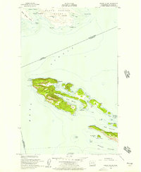
(58)- 1943 Map of Richardson
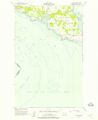
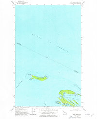
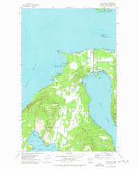
 1943 Richardson1943 Print · USGSLopez Island and the surrounding San Juan archipelago are captured here in the early forties, showing a coastal landscape of maritime hamlets and isolated island life. You can trace early school sites like Center Sch and the harbor at Richardson, or locate the remote Smith Island National Wild Life Refuge.
 - 1943 Map of Orcas Island
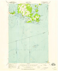
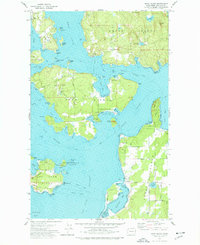
 1943 Orcas Island1943 Print · USGSThe San Juan Islands are captured in the early 1940s, showing a maritime landscape of ferry routes and isolated coastal hamlets. Genealogists and historians can trace local landmarks like Buckhorn Lodge, the Port Stanley Sch, and the CCC Camp in Moran State Park.2 unique versions available
 - 1943 Map of Deception Pass
 1943 Deception Pass1943 Print · USGSFidalgo and Whidbey Islands are shown in the early 1940s, highlighting the maritime and rail connections of Puget Sound. Researchers can trace the boundaries of the Swinomish Indian Reservation or locate early schools like Fidalgo Sch and Dewey Sch.
 - 1943 Map of Anacortes
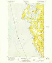
 1943 Anacortes1943 Print · USGSThe San Juan Islands and Skagit coastline appear here in the early 1940s, during an era of remote island schoolhouses and ferry reliance. Genealogists can locate family landmarks like Eden Cem and Guemes Sch, or trace the waterfront of Anacortes and South Bellingham.
 - 1951 Map of Deception Pass, 1953 Print
 1951 Deception Pass1953 Print · USGSWhidbey and Fidalgo Islands appear here in the early fifties as the region's naval and agricultural identities merged. Genealogists and local historians can trace early schools and coastal landmarks like Rosario School, Fort Whitman, and the village of La Conner.3 unique versions available
 - 1951 Map of Anacortes, 1953 Print
 1951 Anacortes1953 Print · USGSThe northern Puget Sound islands and the city of Anacortes are captured here in the early fifties during a period of steady coastal growth. Researchers can locate vanished landmarks and family roots at Eden Cem, Sinclair Sch, and the Lummi Indian Reservation.2 unique versions available
 - 1953 Map of Stuart Island, 1957 Print
 1953 Stuart Island1957 Print · USGSThe San Juan Islands archipelago appears here in the early fifties, caught between the international boundary and the deep channels of the Haro Strait. Researchers can trace early infrastructure like the Lighthouse at Turn Point, the small settlement of Prevost, and island cemeteries.2 unique versions available
 - 1954 Map of Roche Harbor, 1957 Print
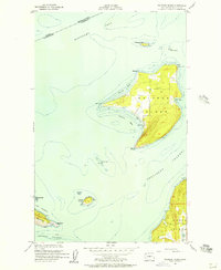
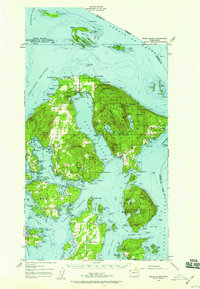
 1954 Roche Harbor1957 Print · USGSSan Juan Island and Henry Island are captured in the 1950s, documenting the maritime life and historic sites of the Pacific Northwest. Trace the boundaries of the English Campsite (1859), locate local Quarries, and find the Lime Kiln Lighthouse.4 unique versions available
 - 1954 Map of Waldron Island, 1957 Print
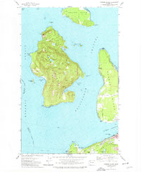
 1954 Waldron Island1957 Print · USGSThe San Juan Islands remained a quiet maritime frontier in the mid-fifties, dominated by rocky shorelines and international waters. Trace the layout of the Waldron settlement, locate the island Cemetery, or find the Abandoned Quarry on the nearby cliffs of Orcas Island.4 unique versions available
 - 1954 Map of Friday Harbor, 1957 Print
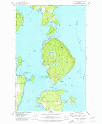
 1954 Friday Harbor1957 Print · USGSSan Juan Island in the mid-fifties shows a landscape of coastal settlements and maritime research centers. Genealogists and historians can locate the St Francis Xavier Mission, the Cem, and the scientific outposts at the Oceanographic Laboratories.4 unique versions available
 - 1954 Map of False Bay, 1957 Print
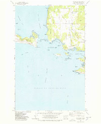
 1954 False Bay1957 Print · USGSSan Juan Island's southern coast is documented here in the mid-fifties, showing the intersection of major straits and the island's rural road network. Historians can locate the American Campsite and Pickett's Monument near Eagle Cove.3 unique versions available
 - 1957 Map of Richardson, 1958 Print
 1957 Richardson1958 Print · USGSLopez Island and the surrounding San Juan archipelago are shown in the late fifties as a landscape of quiet maritime life and isolated beacons. Genealogists and historians can locate the Lopez Sch, trace the roads around Telegraph Hill, and find the Smith Island National Wildlife Refuge.2 unique versions available
 - 1957 Map of Orcas Island, 1959 Print
 1957 Orcas Island1959 Print · USGSThe San Juan Islands are shown here in the late fifties, a time when coastal settlements and island retreats defined the archipelago. Genealogists and historians can trace old community centers like Griswold, Doe Bay, and the early layout of Moran State Park.2 unique versions available
 - 1957 Map of Victoria, 1960 Print
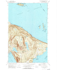
 1957 Victoria1960 Print · USGSThe San Juan Islands and the North Cascades coastline are shown in detail during the late fifties, a period of significant military and industrial presence. Researchers can trace historic rail lines like the Great Northern or locate sites such as the Whidbey Island Naval Air Sta and Friday Harbor.4 unique versions available
 - 1973 Map of Cypress Island, 1977 Print
 1973 Cypress Island1977 Print · USGSThe northern San Juan Islands are captured in the early 1970s, from the rugged interior of Cypress Island to the growing docks of Anacortes. Researchers can trace the layout of small settlements like Urban and Indian Village or locate local landmarks such as Eden Cem and the Sinclair Island Light.2 unique versions available
 - 1973 Map of Lopez Pass, 1977 Print
 1973 Lopez Pass1977 Print · USGSThe eastern shores of the San Juan archipelago are captured here in the early 1970s, showing a landscape defined by saltwater sounds and rocky headlands. Researchers can trace the boundaries of the San Juan Islands National Wildlife Refuge and locate remote landmarks like Davidson Rock Light and Chadwick Hill.2 unique versions available
 - 1973 Map of Sucia Island, 1977 Print
 1973 Sucia Island1977 Print · USGSThe northern San Juan Islands are captured in the early 1970s, showcasing the maritime isolation and nascent parklands of the era. Researchers can locate the Patos Light on the U S Coast Guard Reservation or trace the shoreline of Sucia Island State Park.2 unique versions available
 - 1973 Map of Shaw Island, 1977 Print
 1973 Shaw Island1977 Print · USGSThe San Juan Islands in the early seventies remain a quiet network of maritime communities and protected shorelines. Researchers can trace historic ferry routes and find local landmarks like the Shaw Island Sch, Shaw Co Park, and the Orcas landing.2 unique versions available
 - 1973 Map of Blakely Island, 1977 Print
 1973 Blakely Island1977 Print · USGSThe central San Juan Islands come into focus in the early seventies, showing a maritime landscape of isolated settlements and protected wilderness. Local historians can trace the early footprints of Thatcher and Decatur, alongside landmarks like Blakely Peak and Spencer Spit State Park.3 unique versions available
 - 1975 Map of Bellingham, 1977 Print
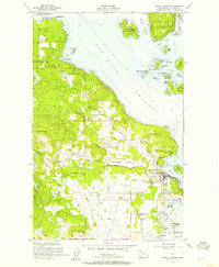
 1975 Bellingham1977 Print · USGSNorthwest Washington in the mid-seventies is captured here, from the Canadian border at Blaine to the San Juan Islands. Researchers can trace tribal lands on the Lummi Indian Reservation, find rural settlements like Cokedale, or follow the Burlington Northern rail lines.
 - 1975 Map of Port Townsend, 1977 Print
 1975 Port Townsend1977 Print · USGSThe northern Puget Sound in the mid-seventies shows a landscape of military readiness and maritime industry. Researchers can trace the extensive Whidbey Island Naval Air Station or locate historic coastal defenses at Fort Casey Military Res and Fort Ebey Military Res.
 - 1977 Map of Richardson, 1978 Print
 1977 Richardson1978 Print · USGSThe San Juan Islands are captured in the late seventies as a landscape of maritime history and budding recreation. Genealogists and researchers can trace the shores of Richardson or explore landmarks like Mt Finlayson and the San Juan Island National Historical Park.2 unique versions available
 - 1977 Map of Eastsound, 1978 Print
 1977 Eastsound1978 Print · USGSOrcas Island in the late seventies is a landscape of protected parks and coastal settlements. Genealogists and island historians can locate the Woodlawn Cem, Orcas Island Sch, and the grounds of Camp Orkila.2 unique versions available
 - 1978 Map of Lummi Island
 1978 Lummi Island1978 Print · USGSLummi Island and the surrounding waters of the Rosario Strait are captured in the late seventies, showing a landscape of coastal settlements and rugged topography. Researchers can trace land use through the Loganita Lodge grounds, the Cem near Lovers Bluff, and the tidal flats of The Portage.2 unique versions available
 - 1978 Map of Mt Constitution
 1978 Mt Constitution1978 Print · USGSOrcas Island in the late 1970s reveals a landscape of high summits and coastal retreats. Genealogists and historians can trace family locations near Buckhorn or the Olga-Doe Bay Cem and locate landmarks like the Prospect and the summit Lookout Tower.3 unique versions available
Showing maps 1-25 of 58
Top cities of San Juan County
Frequently asked questions
- What are the different types of historical maps available for San Juan County?
- What is the oldest map of San Juan County?
- Where can I purchase historical maps of San Juan County for my home or office?
- Where can I download high-res historical maps of San Juan County?
- Are there historical topographic maps available for San Juan County?
- Is there historical aerial imagery available for San Juan County?
- Where are historical maps of San Juan County sourced from?