1990s Maps of Tumwater, Washington
Explore 4 historic maps of Tumwater from the 1990s. These maps offer a rare glimpse into what life looked like during the 1990s — showing old roads, neighborhoods, homes, and landmarks that have changed or disappeared over time.
Whether you're researching your family's past, planning a metal detecting trip, or studying how Tumwater's landscape evolved across the 1990s, these high-resolution maps are a powerful tool for exploring the history of this region.
- Focus on a specific era: All maps on this page are from the 1990s, giving you a focused view of this time period.
- See what’s changed: Compare century-old streets, trails, and buildings to today's modern landscape using overlays and satellite layers.
- Research with precision: Use these maps for genealogy, historical research, land use analysis, or educational projects.
- View, download, or print: Maps are fully viewable online in high resolution, and can be downloaded or printed for your own records.
Start exploring Tumwater's history through authentic maps from the 1990s. This is your window into the past.
Tumwater, WA maps
(4)- 1990 Map of Maytown, 1995 Print
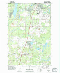 1990 Maytown1995 Print · USGSThurston County settlement and industry are on display in the 1990s as suburban growth meets the rail lines of Maytown. Trace the intersection of the Burlington Northern railroad, the Olympia Airport, and Millersylvania State Park.
 - 1990 Map of East Olympia, 1995 Print
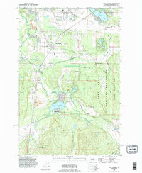 1990 East Olympia1995 Print · USGSThurston County’s prairie and timber lands are captured here in the 1990s as suburban growth reached toward the Deschutes River. Genealogists and historians can trace rail history near Western Junction or explore old settlements like Plumb and Fir Tree.
 - 1991 Map of Tacoma
 1991 Tacoma1991 Print · USGSThe South Sound and Tacoma waterfront appear here in the early nineties, showing a landscape defined by deep-water inlets and massive federal installations. Researchers can trace the development of Lakewood Center or locate the historic rail lines of the Burlington Northern Railroad and Union Pacific Railroad.
 - 1997 Map of Tumwater, 2000 Print
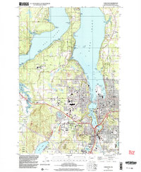 1997 Tumwater2000 Print · USGSThe southern reaches of the Puget Sound come into focus in the late nineties, showcasing the growth of Olympia and Tumwater. Genealogists and local historians can locate early institutions like the McLane Grange Hall, Olympia Jr Academy, and the waterfront Countryside Beach settlement.
End of results
Showing maps 1-4 of 4
Top cities near Tumwater
- Olympia historical maps
- Lacey historical maps
- Shelton historical maps
- Kamilche historical maps
- Grand Mound historical maps
- Rochester historical maps
See more
Top neighborhoods of Tumwater
- Bush historical maps
- Lamberts Corner historical maps
- Belmore historical maps
- The Villas at Kennedy Creek Apartments historical maps
- Tumwater Mobile Estates historical maps
- Barnes Lake Condominiums historical maps
Frequently asked questions
- What are the different types of historical maps available for Tumwater?
- What is the oldest map of Tumwater?
- Where can I purchase historical maps of Tumwater for my home or office?
- Where can I download high-res historical maps of Tumwater?
- Are there historical topographic maps available for Tumwater?
- Is there historical aerial imagery available for Tumwater?
- Where are historical maps of Tumwater sourced from?