1990s Maps of Walla Walla County, Washington
Explore 19 historic maps of Walla Walla County from the 1990s. These maps offer a rare glimpse into what life looked like during the 1990s — showing old roads, neighborhoods, homes, and landmarks that have changed or disappeared over time.
Whether you're researching your family's past, planning a metal detecting trip, or studying how Walla Walla County's landscape evolved across the 1990s, these high-resolution maps are a powerful tool for exploring the history of this region.
- Focus on a specific era: All maps on this page are from the 1990s, giving you a focused view of this time period.
- See what’s changed: Compare century-old streets, trails, and buildings to today's modern landscape using overlays and satellite layers.
- Research with precision: Use these maps for genealogy, historical research, land use analysis, or educational projects.
- View, download, or print: Maps are fully viewable online in high resolution, and can be downloaded or printed for your own records.
Start exploring Walla Walla County's history through authentic maps from the 1990s. This is your window into the past.
Walla Walla County, WA maps
(19)- 1991 Map of Touchet, 1992 Print
 1991 Touchet1992 Print · USGSThe Walla Walla Valley at the start of the nineties reveals a complex network of irrigation ditches and river crossings. Researchers can trace the water-driven economy of Touchet and Gardena through features like the Aqueduct and the Grain Elevator.
 - 1991 Map of Zangar Junction, 1992 Print
 1991 Zangar Junction1992 Print · USGSThe Walla Walla River valley at the Washington-Oregon border is captured here in the early nineties, showing a landscape of essential rural infrastructure. Trace the early layout of Zangar Junction near its Landing Strip or locate local landmarks like Reese and Cummins Bridge Rd.
 - 1991 Map of Rulo, 1992 Print
 1991 Rulo1992 Print · USGSWalla Walla County farmland and river valleys are captured here in the early nineties, centered on the Touchet River drainage. Genealogists and historians can trace the Old Railroad Grade near Rulo or locate landmarks like the Luckenbill Bridge and several storage elevators.
 - 1991 Map of Slater, 1992 Print
 1991 Slater1992 Print · USGSThe Snake River shoreline in Walla Walla County shows a blend of riverfront development and high-desert farming during the early nineties. Researchers can trace local infrastructure through features like the Landing Strip, the settlement of Slater, and the expanse of Eureka Flat.
 - 1991 Map of Levey, 1992 Print
 1991 Levey1992 Print · USGSThe Snake River corridor in the early nineties shows a landscape reshaped by the waters of Lake Sacajawea. Researchers can trace riverside developments at Levey and Ash, or locate recreational landmarks like Fishhook Park and the rugged Juniper Dunes Wilderness.
 - 1991 Map of Lowden, 1992 Print
 1991 Lowden1992 Print · USGSThe Walla Walla Valley at the start of the 1990s reveals a landscape defined by intensive irrigation and agricultural heritage. Researchers can trace historic water routes like the Burlingame Canal or locate the Frenchtown Monument near Lowden.
 - 1991 Map of Hadley, 1992 Print
 1991 Hadley1992 Print · USGSWalla Walla County's agricultural heartland is documented here in the early nineties, showing a landscape defined by grain production and rail history. You can trace the path of the Sudbury Railroad and locate local landmarks like the Climax (Site), the settlement of Berryman, and the Grain Elevator at Thiel.
 - 1991 Map of Snake River, 1992 Print
 1991 Snake River1992 Print · USGSThe Franklin and Walla Walla county borders meet along the river in the early 1990s as grain transport and rail lines define the local economy. Genealogists and historians can trace family-named routes like Mc Clenny Road, locate the Star Sch, and explore riverside depots at Walker and Sheffler.
 - 1991 Map of Page, 1992 Print
 1991 Page1992 Print · USGSWalla Walla County agriculture and the Snake River corridor meet in this early 1990s survey of the Washington interior. Genealogists and local historians can trace the Old RR Grade and find rural infrastructure like Grain Elevators at Hatch and Adkins.
 - 1991 Map of Elwood, 1992 Print
 1991 Elwood1992 Print · USGSEastern Washington's dryland wheat country is captured here in the early nineties, centered on the high plateaus of Eureka Flat. Researchers can trace the rural infrastructure of Elwood, from the central Grain Elevator to family-named routes like Harsell Road and Babcock Road.
 - 1991 Map of Levey SW, 1992 Print
 1991 Levey SW1992 Print · USGSThe Snake River corridor in the early nineties highlights a landscape of massive civil engineering and protected desert terrain. Researchers can trace the infrastructure of the Ice Harbor Lock and Dam and the unique geography of the Juniper Dunes Wilderness.
 - 1991 Map of Eureka, 1992 Print
 1991 Eureka1992 Print · USGSWalla Walla County farming communities thrive in the early nineties amidst the vast stretches of Eureka Flat. Researchers can trace the Old Railroad Grade and locate long-standing rural landmarks like the Grain Elevators at Eureka.
 - 1992 Map of Wallula
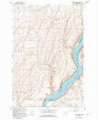
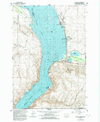 1992 Wallula1992 Print · USGSThe Columbia River corridor near the turn of the 1990s shows a landscape of vital rail lines and river industry. Genealogists and historians can trace the foundations of Wallula and Attalia, and locate landmarks like Wallula Cem and Twin Sisters.
 - 1992 Map of Pasco
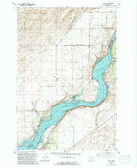
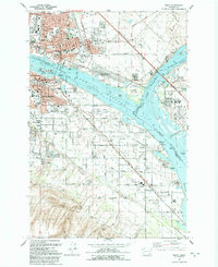 1992 Pasco1992 Print · USGSThe Tri-Cities area thrived during the early nineties as a vital rail and river hub at the meeting of the Columbia and Snake rivers. Genealogists and historians can trace local landmarks like City View Cem, St Patrick Sch, and the Port of Pasco.
 - 1992 Map of Welland
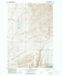
 1992 Welland1992 Print · USGSWalla Walla County agriculture was in full swing in the early nineties, centered on the high plateaus and river valleys. Researchers can trace the rural infrastructure of Welland and find local landmarks like the Grain Elevator and the winding Touchet River.
 - 1992 Map of Humorist
 1992 Humorist1992 Print · USGSWalla Walla County at the confluence of the Snake and Columbia Rivers reveals a landscape shaped by mid-century water management. Researchers can trace the Burlington Northern rail lines and locate the Humorist Cemetery or the Ice Harbor Lock and Dam.
 - 1995 Map of Kooskooskie, 1998 Print
 1995 Kooskooskie1998 Print · USGSThe Washington-Oregon borderlands come into focus in the mid-nineties, showing the intersection of forest management and rural settlement. Researchers can trace the Railroad through Mill Creek Canyon or locate the Kiwanis Camp and Cemetery near Kooskooskie.
 - 1995 Map of Deadman Peak, 1998 Print
 1995 Deadman Peak1998 Print · USGSThe high Blue Mountains in the mid-1990s appear here at the intersection of the Walla Walla and Columbia county lines. Researchers can trace the rugged drainage systems of the South Fork Touchet River and locate historic points like Indian Camp or Table Rock.
 - 1998 Map of Walla Walla, 2003 Print
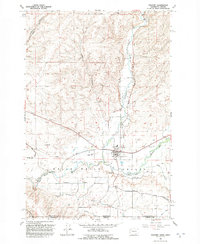
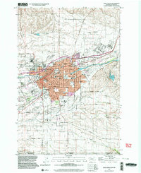 1998 Walla Walla2003 Print · USGSWalla Walla and its surrounding agricultural valleys are captured in the late nineties, documenting a landscape of institutional history and civic growth. Researchers can trace the grounds of the State Penitentiary, find gravesites in Mountain View Cemetery, and locate old schools like De Sales High Sch.
End of results
Showing maps 1-19 of 19
Top cities of Walla Walla County
- Walla Walla historical maps
- College Place historical maps
- Burbank historical maps
- Waitsburg historical maps
- Prescott historical maps
Frequently asked questions
- What are the different types of historical maps available for Walla Walla County?
- What is the oldest map of Walla Walla County?
- Where can I purchase historical maps of Walla Walla County for my home or office?
- Where can I download high-res historical maps of Walla Walla County?
- Are there historical topographic maps available for Walla Walla County?
- Is there historical aerial imagery available for Walla Walla County?
- Where are historical maps of Walla Walla County sourced from?