1970s Maps of Fayette County, West Virginia
Explore 3 historic maps of Fayette County from the 1970s. These maps offer a rare glimpse into what life looked like during the 1970s — showing old roads, neighborhoods, homes, and landmarks that have changed or disappeared over time.
Whether you're researching your family's past, planning a metal detecting trip, or studying how Fayette County's landscape evolved across the 1970s, these high-resolution maps are a powerful tool for exploring the history of this region.
- Focus on a specific era: All maps on this page are from the 1970s, giving you a focused view of this time period.
- See what’s changed: Compare century-old streets, trails, and buildings to today's modern landscape using overlays and satellite layers.
- Research with precision: Use these maps for genealogy, historical research, land use analysis, or educational projects.
- View, download, or print: Maps are fully viewable online in high resolution, and can be downloaded or printed for your own records.
Start exploring Fayette County's history through authentic maps from the 1970s. This is your window into the past.
Fayette County, WV maps
(3)- 1971 Map of Dawson, 1974 Print
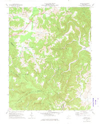 1971 Dawson1974 Print · USGSGreenbrier and Summers counties are captured here in the early seventies, a landscape of steep hollows and high ridges. Researchers can locate remote rural landmarks like Blue Sulphur Springs, Keeney Knob, and small country congregations at Maude Chapel and Mt Zion Ch.
 - 1977 Map of Montgomery, 1980 Print
 1977 Montgomery1980 Print · USGSThe Kanawha Valley is seen in the late seventies as a dense network of industrial activity and riverside settlements. Researchers can trace the footprints of town sites like Montgomery, Smithers, and Boomer along the winding Kanawha River.
 - 1979 Map of Marlinton, 1982 Print
 1979 Marlinton1982 Print · USGSThe West Virginia highlands are shown in detail during the late seventies, featuring the dense rail networks and mountain towns of the Allegheny range. Researchers can trace family roots through sites like Buckeye Cem, Mount Nebo Ch, and the lumber and coal hubs of Richwood and Rainelle.
End of results
Showing maps 1-3 of 3
Top cities of Fayette County
- Oak Hill historical maps
- Fayetteville historical maps
- Ansted historical maps
- Mount Hope historical maps
- Gauley Bridge historical maps
- Boomer historical maps
See more
Frequently asked questions
- What are the different types of historical maps available for Fayette County?
- What is the oldest map of Fayette County?
- Where can I purchase historical maps of Fayette County for my home or office?
- Where can I download high-res historical maps of Fayette County?
- Are there historical topographic maps available for Fayette County?
- Is there historical aerial imagery available for Fayette County?
- Where are historical maps of Fayette County sourced from?